
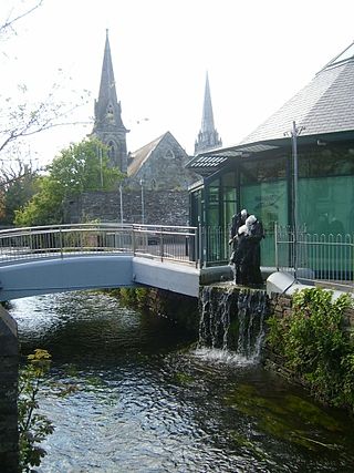
Portlaoise, or Port Laoise, is the county town of County Laois, Ireland. It is located in the South Midlands in the province of Leinster.

Swords, the county town of Fingal, is a large suburban town on the east coast of Ireland, situated ten kilometres north of Dublin city centre. The town was reputedly founded c. AD 560. Located on the Ward River, Swords features Swords Castle, a restored medieval castle, a holy well from which it takes its name, a round tower and a Norman tower. Facilities in the area include the Pavilions shopping centre, one of the largest in the Dublin region, a range of civic offices, some light industries, the main storage facility and archive of the National Museum of Ireland and several parks. Dublin Airport is located nearby.
Clonakilty, sometimes shortened to Clon, is a town in County Cork, Ireland. The town is at the head of the tidal Clonakilty Bay. The rural hinterland is used mainly for dairy farming. The town's population was 4,592 at the 2016 census. The town is a tourism hub in West Cork, and was recognised as the "Best Town in Europe" in 2017, and "Best Place of the Year" in 2017 by the Royal Institute of the Architects of Ireland. Clonakilty is in the Dáil constituency of Cork South-West, which has three seats.

Cobh, known from 1849 until 1920 as Queenstown, is a seaport town on the south coast of County Cork, Ireland. With a population of around 13,000 inhabitants, Cobh is on the south side of Great Island in Cork Harbour and home to Ireland's only dedicated cruise terminal. Tourism in the area draws on the maritime and emigration legacy of the town.

Carrigaline is a town and civil parish in County Cork, Ireland, situated on the River Owenabue. Located about 14 kilometres (8.7 mi) south of Cork city, and with a population of 15,770 people, it is one of the largest commuter towns of the city. The R611 regional road passes through the town, and it is just off the N28 national primary route to Ringaskiddy. Carrigaline grew rapidly in the late 20th century, from a village of a few hundred people into a thriving commuter town although some locals still refer to it as "the village". The town is one of the key gateways to west Cork, especially for those who arrive by ferry from France. Carrigaline is within the Cork South-Central Dáil constituency.
Naas is the county town of County Kildare in Ireland. In 2022, it had a population of 26,180, making it the largest town in County Kildare ahead of Newbridge.

Fermoy is a town on the River Blackwater in east County Cork, Ireland. As of the 2016 census, the town and environs had a population of approximately 6,500 people. It is located in the historical barony of Condons and Clangibbon, and is in the Dáil constituency of Cork East.

Midleton is a town in south-eastern County Cork, Ireland. It lies approximately 16 km east of Cork City on the Owenacurra River and the N25 road, which connects Cork to the port of Rosslare. A satellite town of Cork City, Midleton is part of Metropolitan Cork. It is the central hub of business for the East Cork Area. Midleton is within the Cork East Dáil constituency.
Newbridge, officially known by its Irish name Droichead Nua, is a town in County Kildare, Ireland. While the nearby Great Connell Priory was founded in the 13th century, the town itself formed from the 18th century onwards, and grew rapidly alongside a military barracks which opened in the early 19th century. Taking on the name Newbridge in the 20th century, the town expanded to support the local catchment, and also as a commuter town for Dublin. Doubling in population during the 20 years between 1991 and 2011, its population of 22,742 in 2016 makes it the largest town in Kildare and the fifteenth-largest in Ireland.
Ballincollig is a suburban town within the administrative area of Cork city in Ireland. It is located on the western side of Cork city, beside the River Lee on the R608 regional road. In 2016 it was the largest town in County Cork, at which time the Ballincollig Electoral Division had a population of 18,621 people. It is located beyond the green belt from the suburbs of Bishopstown and Wilton. Historically home to the Ballincollig Royal Gunpowder Mills which is now a Regional Park, the town has seen much growth in recent years as a satellite of Cork City. Ballincollig is within the Cork North-West Dáil constituency.

Debenhams Ireland was a national chain of department stores in Ireland, that was owned ultimately by Debenhams plc. It was largely based on the former Roches Store chain, though after that business divested its grocery units.
Mahon is an area to the south-eastern side of Cork, Ireland. Mahon gets its name from Lough Mahon, a wide stretch of the upper section of Cork Harbour. It was once a semi-rural peninsula, but from the late 20th century was subject to residential development, and has a number of housing estates and developments. The area was generally known as the Ring of Mahon, and is the site of Ringmahon House. Mahon is within the Cork South-Central Dáil constituency.

Douglas is a suburb, with a village core, in Cork city, Ireland. Douglas is also the name of the townland, Roman Catholic parish, Church of Ireland parish and civil parish in which it is contained.

St Patrick's Street is the main shopping street of the city of Cork in the south of Ireland. The street was subject to redevelopment in 2004, and has since won two awards as Ireland's best shopping street. St Patrick's Street is colloquially known to most locals as simply 'Patrick's Street', with the 'St' honorific dropped, in accordance with the pattern applied to many locations named after saints. It is also referred to colloquially by some locals as "Pana", with the first 'a' being elongated.

Kilcrohane is a village in County Cork, Ireland. It is the last coastal village on the Sheep's Head Peninsula after Durrus and Ahakista. Kilcrohane lies under the 'Shadow of Seefin' and is also close to Caher Mountain. The village overlooks Dunmanus Bay.

Cork is the second largest city in the Republic of Ireland and third largest city on the island of Ireland. It is the largest urban centre of the Southern Region and the province of Munster. In the 2022 census, the first following an extension to the city's boundary in 2019, the city had a population of 222,333.

The second largest city in Ireland, Cork, has an economy focused on the city centre, which as of 2011, supported employment for 24,092 people. According to 2006 figures, the top five employers in the area were public sector organisations, and included Cork University Hospital, University College Cork, Collins Barracks, Cork City Council and Cork Institute of Technology. Apple Inc. was the sixth largest employer, followed by Supervalu / Centra Distribution Ltd, Mercy University Hospital, Bon Secours Hospital and Boston Scientific.

Togher is a suburb on the southside of Cork city, Ireland. Togher is within the Dáil constituency of Cork South-Central.

The N40 road is a national primary road in Cork City, Ireland. It is partial ring road skirting the southern suburbs of the city, from the N22 west of Ballincollig, via the Jack Lynch Tunnel under the River Lee, to the Dunkettle Interchange where it meets the N25 and N8/M8. The present N40 designation was created on 23 February 2012 via statutory instrument from parts of both the N22 and N25 built from 1990 onwards. The N40 serves as both a commuter route and a bypass of the city centre for traffic between parts southwest and east. The National Transport Strategy envisages building a "Cork North Ring Road" to complete the circuit in the 2030s.

Wilton Shopping Centre, located in the Wilton area of Cork, is the second biggest shopping centre in the city. It opened on 6 December 1979, and has 65 shops.
