Gaeltacht na nDéise

Last updated • 6 min readFrom Wikipedia, The Free Encyclopedia

Gaeltacht na nDéise
Gaeltacht district
Gaeltacht na nDeise view.jpg
Ireland adm location map.svg
Red pog.svg
Gaeltacht na nDéise
Location in Ireland
Coordinates: 52°03′00″N7°35′00″W / 52.0500°N 7.5833°W / 52.0500; -7.5833
Country Ireland
Province Munster
County Waterford
Area
   Gaeltacht district
62 km2 (24 sq mi)
Population
 (2016)
   Rural
1,816
Time zone UTC+0 (WET)
  Summer (DST) UTC-1 (IST (WEST))
Irish Grid Reference X259930
Website deise.ie

Gaeltacht na nDéise is a Gaeltacht area in County Waterford consisting of the areas of Ring and Old Parish. [1] It is located 10 km from the town of Dungarvan. Gaeltacht na nDéise has a population of 1,816 people (Census 2016) [2] and encompasses a geographical area of 62 km2. This represents 1% of total Gaeltacht area.

Contents

Irish language

The use of the Irish language in the Gaeltacht is tracked at each census. Figures for the use of Irish in Gaeltacht na nDéise are as follows.

YearPopulation (3+)Daily SpeakerDaily Outside EducationDaily SpeakerDaily Outside Education
19961294692-53.5%-
20021388552-39.8%-
2006156974745747.6%29.1%
2011169376945445.4%26.8%
2016173879346745.6%26.9%

Gaeltacht na nDéise is one of the few Gaeltacht areas to have increased its number of daily Irish speakers in census 2016.

Research into the status of the language in the area is carried out from time to time. The last such survey of the area was carried out in May 2006. Given the small population of the area, a full population survey was carried out. The research was carried out on behalf of the local development company, Comhlucht Forbartha na nDéise, by a team from Cork Institute of Technology.[ citation needed ] Over one quarter (29.7%) of households were found to use Irish as the principal home language, over two thirds (68.6%) were principally English speaking while a small minority (0.5%) another language was the principal language of the home. More than six-sevenths (86.3%) of respondents reported the ability to speak Irish, 13.7% reported that they are unable to speak Irish. Of those who speak Irish, well over three quarters speak Irish at home, with over half (53.5%) speaking Irish at home on a daily basis.[ citation needed ] Over one third of those claiming the ability to speak Irish reported speaking Irish at work and with friends on a daily basis. When asked if they wished to retain their status as a Gaeltacht area, the residence of Gaeltacht na nDéise gave a nearly unanimous response with 98% in favour.[ citation needed ]

Language planning

Acht na Gaeltachta 2012 has set out a language planning process that will be undertaken in 26 Language Planning Areas throughout the Gaeltach, as set out by The Department of Arts, Heritage and the Gaeltacht. Gaeltacht na nDéise constitutes a single Language Planning Area under the act. A 'Ceanneagraíocht' or lead-organisation is selected by Údarás na Gaeltachta to develop a language plan aimed at increasing the use of Irish in their community. [3] Comhlucht Forbartha na nDéise was selected by Údarás na Gaeltachta as the lead-organisation for Gaeltacht na nDéise. As such, Comhlucht Forbartha na nDéise had two years to develop a seven-year language plan for the area.[ needs update ]

Economy

Commerce and employment

Commercial fishing from the local fishing pier or Cé Heilbhic and Agriculture are sources of employment and economic activity in the area,[ citation needed ] though the importance of both has declined in recent years.[ when? ] Education is also a source of employment in both publicly and privately funded. Electronic manufacturing and the televisual sector which supplies TG4 and the international market are also contributors to the local economy.[ citation needed ] In 2011 there were 121 people employed in a full-time capacity in Údarás na Gaeltachta client companies in the Waterford Gaeltacht. [4] By 2019, 149 people were employed full time in client companies of Údarás na Gaeltachta in the Waterford Gaeltacht.[ citation needed ] The area is somewhat disadvantaged, with a higher unemployment rate than the national average.[ citation needed ] There is a disparity between Ring and Old Parish in terms of economic development with Old Parish being at a lower level of economic development. [5] [ full citation needed ]

Tourism sites

Signage directing people to Reilig an tSleibhe, the famine graveyard in the Waterford Gaeltacht Reilig an tSleibhe.jpg
Signage directing people to Reilig an tSléibhe, the famine graveyard in the Waterford Gaeltacht
Statue at Reilig an tSleibhe Reilig an tSleibhe - Statue.jpg
Statue at Reilig an tSléibhe
An Imearlann, the playground in Ring An Imearlann.jpg
An Imearlann, the playground in Ring
An Pairc Uile Aimsire, Old Parish An Pairc Uile Aimsire.jpg
An Páirc Uile Aimsire, Old Parish

Tourism is an important part of the local economy in Gaeltacht na nDéise. Sites in the area include Reilig an tSléibhe, a famine graveyard located in An Seanphobal. Dating from the Great Famine, there are possibly 3 mass graves in the field that were used to cope with the large numbers and as the deaths declined, it is believed single graves were dug. In 1995, for the 150th commemoration of the famine, a memorial was created which was inscribed with part of Máire Ní Dhroma's poem, Na Prátaí Dubha. Also to be seen at the site is a solitary sculpted figure in mourning, at the side of the field. This sculpture was created by Seán Creagh; he died before it was complete and so the fibreglass structure that would have been used to create the mould for the final piece was erected instead. None of the graves at the site are marked in any way. Within the field there is, however, a headstone where G. R. Jacobs from the HMT Bradford is buried. He died at sea in 1916. [6] [ full citation needed ]

Tourism development

Comhlucht Forbartha na nDéise commissioned a report into Cultural Tourism in Gaeltacht na nDéise in 2014. This report was part of a wider tourism development project in the Gaeltacht that was largely funded by Waterford Leader Partnership. The study was undertaken by Dungarvan-based HandsOnEvents. The report found that significant cultural tourism development potential exists in the area due to the natural environment of the area, its cultural richness in terms of language, music and the arts, built heritage combined with the considerable enthusiasm by the local community. [7] [ full citation needed ]

As a result of this, a new tourism development committee, An Coiste Fáilte, which is a sub-committee of Comhlucht Forbartha na nDéise has recently been established in the area. The purpose of An Coiste Fáilte is to develop and enhance the area for both locals and tourists alike, and to focus primarily on the Irish Language, Culture and History of the area. This will ensure the sustainability of the area and preserve the history and traditions for future generations to come. Projects undertaken by this group include the development of Reilig an tSléibhe, the local Famine Graveyard, Aonach an Phátrúin, a Christmas Market organised on the Patron Saint's day in the area and the development of the areas presence as part of the new Ireland's Ancient East initiative.

Townlands

The Gaeltacht area is defined by the townlands that are deemed to be part of that Gaeltacht, Gaeltacht na nDéise was defined in the Gaeltacht Areas Order, 1956 and expanded in Gaeltacht Areas Order, 1974. Below is the list of townlands that currently constitute Gaeltacht na nDéise.

Áthán, Baile an Róid, Baile an tSléibhe Thuaidh, Baile an tSléibhe Theas, Baile Uí Churraoin Thuaidh, Baile Uí Churraoin Theas, Baile Mhic Giolla Mhuire, Baile Mhac Airt Íochtarach, Baile Mhac Airt Uachtarach, Baile na Cúirte Thuaidh, Baile na Cúirte Theas, Baile na nGall Beag, Baile na nGall Mór, Baile na hArda, Baile na Móna Íochtarach, Baile na Móna Uachtarach, Baile Uí Raghallaigh, Baile Threasnáin, Barr na Léithe, Barr na Stuac, An Carraigín, An Chúil Rua, Cruabhaile Íochtarach, Cruabhaile Uachtarach, An Coinigéar, An Fhaiche, Fearann an Lóintigh, Na Geataí, Gleann an Fhíoruisce, An Goirtín, Gort na Daibhche Íochtarach, Gort na Daibhche Uachtarach, An Gabhlán, Sliabh an Ghabhláin, Baile an Aicéadaigh, Heilbhic, Cill Cholmáin, Cill an Fhuarthainn, Cnocán an Phaoraigh Íochtarach, Cnocán an Phaoraigh Uachtarach, An Cnocán Rua, Cnoc an Fhréinigh, Cnoc na gCapall, Log na Giumhaisí, An Léith, Loiscreán, An Mhóin Bhreac, An Mhóin Fhionn, An Móta, Móin an Ghiumhais, Móin na mBian, Móin na mBráthar, Móin an Fhia, Maoil an Choirnigh, Ráth Léad, Ráth na mBiníneach, An Ré Dhóite, An Ré Mheánach, Ré na gCloichín, Ré na gCuilí, Na Roisíní, An Scardán, An Screathan, Seanchluain, An tSeanchill, An Seanbhaile. [8]

Related Research Articles

<span class="mw-page-title-main">County Waterford</span> County in Ireland

County Waterford is a county in Ireland. It is in the province of Munster and is part of the Southern Region. It is named after the city of Waterford. Waterford City and County Council is the local authority for the county. The population of the county at large, including the city, was 127,363 according to the 2022 census. The county is based on the historic Gaelic territory of the Déise. There is an Irish-speaking area, Gaeltacht na nDéise, in the southwest of the county.

<i>Gaeltacht</i> Primarily Irish-speaking regions in Ireland

A Gaeltacht is a district of Ireland, either individually or collectively, where the Irish government recognises that the Irish language is the predominant vernacular, or language of the home. The Gaeltacht districts were first officially recognised during the 1920s in the early years of the Irish Free State, following the Gaelic revival, as part of a government policy aimed at restoring the Irish language.

<span class="mw-page-title-main">Iveragh Peninsula</span> Peninsula in County Kerry, Ireland

The Iveragh Peninsula is located in County Kerry in Ireland. It is the largest peninsula in southwestern Ireland. A mountain range, the MacGillycuddy's Reeks, lies in the centre of the peninsula. Carrauntoohil, its highest mountain, is also the highest peak in Ireland.

<span class="mw-page-title-main">Dungarvan</span> Town in County Waterford, Ireland

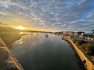
Dungarvan is a coastal town and harbour in County Waterford, on the south-east coast of Ireland. Prior to the merger of Waterford County Council with Waterford City Council in 2014, Dungarvan was the county town and administrative centre of County Waterford. Waterford City and County Council retains administrative offices in the town. The town is in a townland and civil parish of the same name.

<span class="mw-page-title-main">Ballyferriter</span> Village in County Kerry, Ireland

Baile an Fheirtéaraigh unofficially anglicised as Ballyferriter, or also known as An Buailtín, is a Gaeltacht village in County Kerry, Ireland. It is in the west of the Corca Dhuibhne (Dingle) peninsula and according to the 2002 census, about 75% of the town's population speak the Irish language on a daily basis. The village is named after the Norman-Irish Feiritéar family who settled in Ard na Caithne in the late medieval period. The last Chief of the Name was the seventeenth-century Bard and leader Piaras Feiritéar who was executed. The older Irish name for the village An B[h]uailtín is still used locally.

<span class="mw-page-title-main">Údarás na Gaeltachta</span> Irish state agency for the socioeconomic and cultural reinforcement of the Gaeltacht

Údarás na Gaeltachta, abbreviated UnaG, is a regional state agency which is responsible for the economic, social and cultural development of Irish-speaking (Gaeltacht) regions of Ireland. Its stated purpose is to strengthen the Gaeltacht communities, to increase the quality of life of its community members and facilitate the preservation and extension of the Irish language as the principal language of the region. It gives funding to small local businesses that have to compete with foreign companies.

<span class="mw-page-title-main">Furbo, County Galway</span> Village in County Galway, Ireland

Furbo or Furbogh is a settlement in Connemara, County Galway, Ireland. As of the 2022 census, it had a population of 868 people. It lies along the coast, overlooking Galway Bay, in a Gaeltacht area.

<span class="mw-page-title-main">Munster Irish</span> Irish language dialect

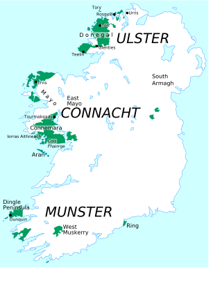
Munster Irish is the dialect of the Irish language spoken in the province of Munster. Gaeltacht regions in Munster are found in the Gaeltachtaí of the Dingle Peninsula in west County Kerry, in the Iveragh Peninsula in south Kerry, in Cape Clear Island off the coast of west County Cork, in Muskerry West; Cúil Aodha, Ballingeary, Ballyvourney, Kilnamartyra, and Renaree of central County Cork; and in an Rinn and an Sean Phobal in Gaeltacht na nDéise in west County Waterford.

Coimisiún na Gaeltachta, abbreviated CnaG, was an Irish government agency which worked from 2000 to 2002 to draft recommendations to strengthen the role of the Irish language in the Gaeltacht, the Irish-language-speaking area of Ireland. It was established at the instigation of Éamon Ó Cuív, the then Minister of State at the Department of Arts, Heritage, Gaeltacht and the Islands and its work completed under the guidance of his successor, Mary Coughlan. The Irish Government approved the publication of the Commission's report, without commitment.

<span class="mw-page-title-main">Ring, County Waterford</span> Gaeltacht in Munster, Ireland

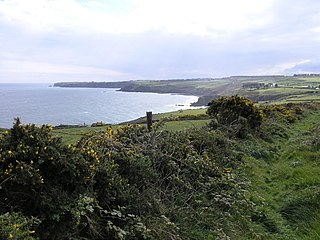
Ring or Ringagonagh is a parish within the Irish-speaking Gaeltacht na nDéise area in County Waterford, Ireland. It lies on a peninsula about eleven kilometres (7 mi) south of Dungarvan. The main settlement is the village of Ring or Ringville, which is within the townland of Ballynagaul.

Gluaiseacht Cearta Sibhialta na Gaeltachta or Coiste Cearta Síbialta na Gaeilge, was a pressure group campaigning for social, economic and cultural rights for native-speakers of Irish living in Gaeltacht areas. It was founded in Connemara in 1969 to highlight the decline of the Irish language and to campaign for greater rights for Irish speaking areas in the area of access to services, broadcasting and ultimately an elected assembly of their own. It was later named Gluaiseacht na Gaeltachta.

Rinn Ó gCuanach CLG is a Gaelic Athletic Association club based in the Irish speaking (Gaeltacht) area of Ring, County Waterford, Ireland. The club fields teams of both GAA codes, including two adult Gaelic football teams and two adult hurling teams in the Waterford County Championships. It is one of a small number of dual clubs at senior level in the county, competing in the Senior Hurling and Senior Football championships. The club's second string teams take part in the Waterford Junior Hurling and Football championships.

<span class="mw-page-title-main">Old Parish</span> Village in County Waterford, Ireland

Old Parish is a village in west County Waterford, Ireland. It is part of the Gaeltacht in Waterford Gaeltacht na nDéise.

A Neo-Gaeltacht is an area where Irish has a strong presence as a spoken language but is not part of the officially defined or traditional Gaeltacht areas. It has been argued that non-Gaeltacht activist groups wishing to establish an Irish language community need to show that it is large, permanent and formally organised and that it has a growing number of people using Irish as their first language. Another objective is a situation in which children use Irish among themselves and with other Irish speakers in a natural way while being able to deal with a largely English-speaking world.

A naíonra is an Irish medium playgroup for pre-school children, which follows the principle of Total Early Immersion.

<span class="mw-page-title-main">Baile Ghib</span> Village and Gaeltacht in County Meath, Ireland

Baile Ghib is a small village and Gaeltacht in County Meath, Ireland. It is about 70km northwest of Dublin city. Local Link bus route 186 was introduced in October 2024 and links the area several times daily to Kells and other villages in Meath & Cavan.

<span class="mw-page-title-main">Cois Fharraige</span>

Cois Fharraige, previously spelled Cois Fhairrge, is a coastal area west of Galway city, where the Irish language is the predominant language. It stretches from Na Forbacha, Bearna, An Spidéal to Indreabhán. There are between 8,000 and 9,000 people living in this area.

<span class="mw-page-title-main">Ballynagaul, County Waterford</span> Gaeltacht district in Munster, Ireland

Ballynagaul is a Gaeltacht area within the Irish-speaking Gaeltacht na nDéise part of County Waterford. Comprising the townlands of Baile na nGall Mór and Baile na nGall Beag, it is located approximately 9.6 kilometres southeast of Dungarvan. The village of Ring is located in the area.

<span class="mw-page-title-main">Gaeltacht Act 2012</span> Act of the Oireachtas (Irish parliament)

The Gaeltacht Act 2012 is an Act of the Oireachtas of Ireland. The Act redefined the traditional Irish-speaking areas or Gaeltacht in the Republic of Ireland on linguistic criteria instead of on geographic areas which had been the position until 2012. While the traditional Gaeltacht boundaries still exist the Act sets out ways where areas outside the Gaeltacht can be formally designated as Irish Language Networks and Gaeltacht Service Towns.

<span class="mw-page-title-main">Gaeltacht Service Town</span> State designation of selected urban areas in Ireland

A Gaeltacht Service Town is an area designated under the Gaeltacht Act 2012, situated in or adjacent to Gaeltacht areas in Ireland, that have a population of over 1,000 people, and which play a significant role in providing public services, recreational and commercial facilities for Gaeltacht residents.

References

  1. "An Ghaeltacht". Waterford County Local Authorities. Waterford County Council, Civic Offices, Dungarvan, Co. Waterford. Archived from the original on 22 January 2014. Retrieved 6 July 2014.
  2. "Sapmap Area - Gaeltacht - Ghaeltacht Phort Láirge". Census 2016. Central Statistics Office. April 2016. Archived from the original on 28 July 2020. Retrieved 30 June 2021.
  3. "The Language Planning Process in the Gaeltacht". Údarás na Gaeltachta. 20 June 2014.
  4. "Waterford". Údarás na Gaeltachta. 20 June 2014.
  5. Gaeltacht na nDéise - A Socio-economic and Cultural needs analysis.
  6. Dungarvan Observer - 09-10-2015
  7. Gaeltacht na nDéise - Cultural Tourism Report 2014
  8. "An tOrdú Logainmneacha (Ceantair Ghaeltachta) 2004" (PDF). Logainm.ie. Retrieved 13 December 2015.