List of coastal fortifications of County Cork

Last updated

A number of coastal fortifications were built in County Cork, Ireland, to defend the county's coastline, and in particular the strategic berths at Cork Harbour, Kinsale Harbour, Berehaven and Bantry Bay. The fortifications initially included medieval tower houses built to defend strategic points (14th-17th centuries), subsequent Martello towers designed to counter threatened French invasion (18th-19th centuries), and later Palmerston Forts to further improve coastal defence (19th century). The latter were subsequently updated with longer-range coastal artillery - to support the naval defence of the "Western Approaches" during the First World War (early 20th century).

Contents

Cork Harbour

As one of the world's largest natural harbours, Cork Harbour's defences were built from medieval times up to the 20th century to defend the Port of Cork, Haulbowline naval yards, and Naval Air Station at Queenstown. Some of these defences were tested during the Siege of Cork (1690) and Fenian Rising (1867) - the harbour remains the home-port of the Irish Naval Service.

NameLocationTypeImageEraCoordinatesNotes
Lower Harbour
Fort Davis (Carlisle) Whitegate Coastal defence fortification (Palmerston fort) Fort Davis Whitegate Cork Harbour County Cork Ireland.JPG 17th century (original castle)
19th century (reconstruction)
51°48′58″N8°15′40″W / 51.816°N 8.261°W / 51.816; -8.261 Derelict in some areas, [1] but remains an active Defence Forces site. [2]
Fort Meagher (Camden) Crosshaven (Rams Head)Coastal defence fortification (Palmerston fort) Over looking camden.jpg 16th century (original fort)
19th century (reconstruction)
51°48′29″N8°16′44″W / 51.808°N 8.279°W / 51.808; -8.279 Redeveloped as a heritage tourism site [3]
Fort Mitchel (Westmoreland) Spike Island Star fort (later prison) Spike Island Cork Fort Mitchel Gates.jpg 18th/19th century 51°50′06″N8°17′10″W / 51.835°N 8.286°W / 51.835; -8.286 Redeveloped as a heritage tourism attraction. [4] [5]
Fort Templebreedy (Battery) Crosshaven (Church Bay) Land battery 20th century 51°47′24″N8°16′59″W / 51.790°N 8.283°W / 51.790; -8.283 Demilitarised but remains Defence Forces property. [6]
Cove Fort Cobh (Cuskinny)Land battery Cove Fort Cork Harbour from Charles Vallancey Survey 1777.jpg 18th century 51°51′06″N8°16′38″W / 51.8518°N 8.2771°W / 51.8518; -8.2771 Build in 1743 to replace temporary batteries defending the berths at Cobh and Haulbowline. [7] Now the site of a Port of Cork facility and memorial garden.
Middle and Upper Harbour
Belvelly Castle Belvelly Norman tower house Castles of Munster- Belvelly, Cork (geograph 3036861).jpg 14th or 15th century 51°53′17″N8°18′07″W / 51.888°N 8.302°W / 51.888; -8.302 In private ownership [8]
Martello towers (x5) Great Island (3), Haulbowline (1), Ringaskiddy (1)Martello towers Martello Tower, Belvelly Townland (geograph 1901898).jpg 19th centuryRingaskiddy: 51°49′42″N8°18′35″W / 51.8284°N 8.3098°W / 51.8284; -8.3098
Haulbowline: 51°50′30″N8°18′27″W / 51.8416°N 8.3074°W / 51.8416; -8.3074
Monning: 51°53′15″N8°19′13″W / 51.8874°N 8.3202°W / 51.8874; -8.3202
Belvelly: 51°53′17″N8°18′17″W / 51.8881°N 8.3047°W / 51.8881; -8.3047
Rossleague: 51°53′01″N8°16′35″W / 51.8837°N 8.2764°W / 51.8837; -8.2764
Towers at Ringaskiddy, Haulbowline, Belvelly, Rossleague and Marino Point. The latter, "Monning Tower", was briefly held by Captain Mackey during the 1867 Fenian Rising. [9] Haulbowline tower is now a museum store. [10] One is a residence. [11]
Blackrock Castle Blackrock Castle Blackrock Castle (Blackrock, Co.Cork).jpg 17th century (original)
19th century (reconstruction)
51°54′00″N8°24′10″W / 51.9°N 8.4029°W / 51.9; -8.4029 Though some of the 17th century structure remains, most features were built after a 19th-century fire, and it now houses an observatory [12]
Dundanion Castle Blackrock Tudor tower house Dundanion Castle - Ballintemple Blackrock Cork - July 2013.JPG 16th century 51°53′51″N8°25′13″W / 51.8974°N 8.4204°W / 51.8974; -8.4204 Ruin on private land

Kinsale Harbour and approaches

From medieval times, the harbour and berths at Kinsale were of strategic importance, and its defences were tested during the Battle of Kinsale (1601) and Williamite War (1690). Though declining in importance (relative to those at Cork Harbour) in the 18th and 19th centuries, several structures were in use until they were burned during the Irish Civil War (1922).

NameLocationTypeImageEraCoordinatesNotes
Charles Fort (New Fort) Kinsale (Summer Cove)Coastal star fort Kinsale-fortress.panorama.jpg 16th century (early castle)
17th century (current fort)
51°41′49″N8°29′56″W / 51.697°N 8.499°W / 51.697; -8.499 Though internals were burned-out during the Civil War, key structures are intact (or rebuilt) and operated by the OPW as a heritage tourism site [13]
James Fort (Old Fort) Kinsale (Castle Park) Pentagonal fort James Fort, Kinsale, West Cork.JPG 16th and 17th century 51°41′56″N8°30′36″W / 51.699°N 8.510°W / 51.699; -8.510 Damaged during the Williamite War (1690) and later left to ruin. Open to public. [14]
Ringrone Castle River Bandon (Ringrone) Tower house Castles of Munster, Ringrone, Cork - geograph.org.uk - 1392916.jpg 13th century 51°41′N8°32′W / 51.69°N 8.53°W / 51.69; -8.53 Built by the de Courcy family [15] (Barons of Kinsale). Now a complete ruin
Old Head Castle Old Head of Kinsale Tower house No access to Old Head of Kinsale - geograph.org.uk - 1571027.jpg 13th century 51°37′05″N8°32′31″W / 51.618°N 8.542°W / 51.618; -8.542 Another de Courcy castle built in defence of the Kinsale coast. Only some walls remain [16] A nearby signal tower (1805) has since been restored. [17]

Bantry Bay and Berehaven Harbour

The deep-water berths at Bantry Bay and Berehaven Harbour were important from as early as the Nine Years' War and Siege of Dunboy in 1602, through the United Irishmen Rebellion and French Armada landings in the 1790s. The defences remained critical to support the Bantry Bay (anti-submarine) Naval Air Station during World War 1, and Berehaven "Treaty Port" was used by the Royal Navy fleet until it was relinquished in 1938 under the terms of the Anglo-Irish Treaty.

NameLocationTypeImageEraCoordinatesNotes
Dunboy Castle Beara Peninsula Castle Iarthair Chorcai 075.jpg 15th or 16th century 51°37′59″N9°55′26″W / 51.633°N 9.924°W / 51.633; -9.924 An O'Sullivan Bere castle built to defend Bantry Bay and Berehaven harbour. Ruined since the Siege of Dunboy (1602)
Martello towers Garnish Island, Whiddy Island, Bere Island Martello towers Garinish Island Tower, Glengarriff, Co. Cork (19919085130).jpg 19th centuryGarinish: 51°44′10″N9°32′31″W / 51.736°N 9.542°W / 51.736; -9.542
Whiddy: 51°40′55″N9°31′08″W / 51.682°N 9.519°W / 51.682; -9.519
Bere: 51°38′02″N9°50′56″W / 51.634°N 9.849°W / 51.634; -9.849
Built to defend the deep water berths of Bantry Bay, four towers were built on Bere Island (2 remain), with others on Whiddy and Garnish. [18]

Baltimore and Roaring Water Bay

The defences at Baltimore, Roaring Water Bay and surrounding islands were largely built by landed families from the 14th to 17th centuries. Some were relinquished (but later returned) after the Nine Years' War (1603) and involved in the Sack of Baltimore (1631).

NameLocationTypeImageEraCoordinatesNotes
Dún na Séad Baltimore, County Cork Tower house Fort of the Jewels - geograph.org.uk - 1755185.jpg 14th to 17th century 51°28′59″N9°22′23″W / 51.483°N 9.373°W / 51.483; -9.373 Built on an earlier Anglo-Norman structure, Dún na Séad castle (Fort of the Jewels) was an O'Driscoll stronghold
Dún na Long and Dún an Óir Castles Cléire and Sherkin Islands Tower houses Dun an Oir, Cleire (geograph 2612642).jpg 15th to 17th centurySherkin: 51°28′37″N9°24′07″W / 51.477°N 9.402°W / 51.477; -9.402
Cléire: 51°26.28′N9°30.86′W / 51.43800°N 9.51433°W / 51.43800; -9.51433
Built by the O'Driscolls in the same period as the island's friary, Sherkin's Dún na Long (Fort of the Ships) and Cléire's Dún an Óir (Fort of Gold, pictured) were intended to defend the approaches to Baltimore and Roaring Water Bay

See also

Related Research Articles

<span class="mw-page-title-main">Martello tower</span> Small defensive fort

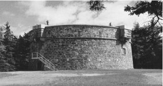
Martello towers, sometimes known simply as Martellos, are small defensive forts that were built across the British Empire during the 19th century, from the time of the French Revolutionary Wars onwards. Most were coastal forts.

<span class="mw-page-title-main">Dunboy Castle</span> Ruined castle in Ireland

Dunboy Castle is a ruined 15th century castle on the Beara Peninsula in south-west Ireland near the town of Castletownbere. The castle's tower house and bawn were destroyed in the 1602 Siege of Dunboy, though its ruins remain open to the public.

<span class="mw-page-title-main">Bantry</span> Town in County Cork, Ireland

Bantry is a town in the civil parish of Kilmocomoge in the barony of Bantry on the southwest coast of County Cork, Ireland. It lies in West Cork at the head of Bantry Bay, a deep-water gulf extending for 30 km (19 mi) to the west. The Beara Peninsula is to the northwest, with Sheep's Head peninsula to the southwest.

<span class="mw-page-title-main">Castletownbere</span> Town in County Cork, Ireland

Castletownbere is a town in County Cork in Ireland. It is located on the Beara Peninsula by Berehaven Harbour. It is also known as Castletown Berehaven.

<span class="mw-page-title-main">Ringaskiddy</span> Port village in County Cork, Ireland

Ringaskiddy is a village in County Cork, Ireland. It is located on the western side of Cork Harbour, south of Cobh, and is 15 kilometres (9 mi) from Cork city, to which it is connected by the N28 road. The village is a port with passenger ferry, with two bi-weekly sailings to Roscoff in France. A ferry service to Swansea in Wales closed in 2012.

<span class="mw-page-title-main">Cork Harbour</span> Harbour in Ireland

Cork Harbour is a natural harbour and river estuary at the mouth of the River Lee in County Cork, Ireland. It is one of several which lay claim to the title of "second largest natural harbour in the world by navigational area". Other contenders include Halifax Harbour in Canada, Trincomalee Harbour in Sri Lanka and Poole Harbour in England.

<span class="mw-page-title-main">Great Island</span> Island in Cork Harbour, Ireland

Great Island is an island in Cork Harbour, at the mouth of the River Lee and close to the city of Cork, Ireland. The largest town on the island is Cobh. The island's economic and social history has historically been linked to the naval, ship-building, and shipping activities in the town's environs.

<span class="mw-page-title-main">Treaty Ports (Ireland)</span>

Following the establishment of the Irish Free State, three deep water Treaty Ports at Berehaven, Spike Island, and Lough Swilly were retained by the United Kingdom in accordance with the Anglo-Irish Treaty of 6 December 1921.

<span class="mw-page-title-main">Bere Island</span> Island in County Cork, Ireland

Bere Island or Bear Island is an island in Bantry Bay off the Beara Peninsula in County Cork, Ireland. It spans roughly 10 km x 3 km, with an area of 17.68 km², and, as of 2012, had a population of between 210 and 220 people.

<span class="mw-page-title-main">Spike Island, County Cork</span> Island in County Cork, Ireland

Spike Island is an island of 103 acres (42 ha) in Cork Harbour, Ireland. Originally the site of a monastic settlement, the island is dominated by an 18th-century bastion fort now named Fort Mitchel.

<span class="mw-page-title-main">Haulbowline</span> Island in Cork Harbour, Ireland

Haulbowline is an island in Cork Harbour off the coast of Ireland. The world's first yacht club was founded on Haulbowline in 1720. The western side of the island is the main naval base and headquarters for the Irish Naval Service, with the eastern side previously used for heavy industry and later redeveloped as a park. Since 1966 the island has been connected to the mainland by a roadbridge.

<span class="mw-page-title-main">James's Fort</span> Bastion fort in County Cork, Ireland

James Fort is an early 17th-century pentagonal bastion fort located on Castlepark peninsula in Kinsale harbour, County Cork, Ireland. Situated downstream from Kinsale on the River Bandon, the fort was built to defend the harbour and seaborne approaches of the town. Following the construction of Charles Fort on the opposite side of the harbour in the late 17th century, James Fort became known as the "old fort". Listed as a protected National Monument, and managed by the Office of Public Works, the fort is open to visitors.

<span class="mw-page-title-main">Charles Fort (Ireland)</span> Bastion fort in County Cork, Ireland

Charles Fort is a trace italien fortification, a bastion fort with one section of the outer wall built in star fashion. It is located on the water's edge, at the southern end of the village of Summer Cove, on Kinsale harbour, County Cork, Ireland. First completed in 1682, Charles Fort was sometimes historically referred to as the "new fort" - to contrast with James' Fort which had been built on the other side of Kinsale harbour before 1607. The fort is now operated as a heritage tourism site by the Heritage Ireland arm of the Office of Public Works.

<span class="mw-page-title-main">Dunasead Castle</span>

Dunasead Castle, sometimes known as Baltimore Castle, is a 17th-century fortified house situated in the town of Baltimore in western County Cork, Ireland. The tower house is built on the site of an earlier Norman-era structure, which itself replaced an earlier Bronze Age ringfort. Traditionally associated with the O'Driscoll family, it was purchased and restored by members of the McCarthy family in the late 1990s, and partially opened to the public from 2005.

<span class="mw-page-title-main">Blackrock Castle</span>

Blackrock Castle is a castellated fortification located at Blackrock, about 2 km from Cork city centre on the banks of the River Lee in Ireland. Originally developed as a coastal defence fortification in the 16th century to protect upper Cork Harbour and port, the site now houses an observatory, visitor centre and restaurant.

<span class="mw-page-title-main">Camden Fort Meagher</span>

Camden Fort Meagher is a coastal defence fortification close to Crosshaven, County Cork, Ireland. Together with similar structures at Fort Mitchell, Fort Davis (Whitegate), and Templebreedy Battery, the fort was built to defend the mouth of Cork Harbour. Though originally constructed in the 16th century, the current structures of the fort date to the 1860s. Originally named Fort Camden and operated by the British Armed Forces, the fort was handed-over to the Irish Defence Forces in 1938. Renamed Fort Meagher in honour of Thomas Francis Meagher, it remained an Irish military installation until 1989 when the Irish Army handed the fort over to Cork County Council. It remained largely overgrown until 2010 when a group of local volunteers began restoration and development of the fort for heritage and tourism purposes. The fort was renamed Camden Fort Meagher and is now open seasonally to visitors, with exhibits on the fort's Brennan torpedo installation.

<span class="mw-page-title-main">Fort Davis, County Cork</span>

Fort Davis, is a coastal defence fortification close to Whitegate, County Cork, Ireland. Together with similar structures at Fort Mitchel, Fort Camden (Crosshaven), and Templebreedy Battery, the fort was built to defend the mouth of Cork Harbour. Though used as a fortification from the early 17th century, the current structures of the 74-acre site date primarily from the 1860s. Originally named Fort Carlisle and operated by the British Armed Forces, the fort was handed-over to the Irish Defence Forces in 1938, and renamed Fort Davis. The facility is owned by the Department of Defence, and is used as a military training site with no public access.

<span class="mw-page-title-main">Fort Templebreedy</span>

Fort Templebreedy, also known as Templebreedy Battery, was a coastal defence fortification close to Crosshaven, in County Cork, Ireland. Supplementing a number of earlier structures at Fort Camden and Fort Davis, the site was developed between 1904 and 1909 to defend the mouth of Cork Harbour. Used as a coastal artillery position until the 1940s, and as a military training camp until the late 20th century, many of the structures of the 37-acre site were dismantled over time, and part of the complex used as a pitch and putt course. In 2009, Cork County Council added the site to a proposed list of protected structures – though as of 2020 it remains in the ownership of the Department of Defence.

<span class="mw-page-title-main">Cove Fort, County Cork</span>

Cove Fort is a small bastioned land battery to the east of Cobh in County Cork, Ireland. Built as a coastal defence fortification in 1743, on instruction of the then Vice-Admiral of the Coast, it replaced a number of temporary coastal artillery batteries which defended Cork Harbour.

29 Martello towers and battery installations were constructed or partially constructed in the Greater Dublin Area between 1803 and 1808. The towers were intended to act as a deterrent against a foreign invasion by Napoleon and his French Armies as well as being used as general lookout posts. In later years, towers were also used as coast guard stations, lookout stations to prevent smuggling and as other general purpose military installations by various British and Irish defence forces.

References

  1. "Buildings of Ireland - Fort Davis". National Inventory of Architectural Heritage . Retrieved 19 March 2015.
  2. Defence Forces Annual Report (PDF) (Report). Irish Defence Forces. 2003. p. 21. Retrieved 23 March 2015.
  3. "Hidden Ireland: Local spirit brings Fort Camden brought back to life". TheJournal.ie. 22 September 2012. Retrieved 4 June 2014.
  4. "Plan to unlock potential of 'Ireland's Alcatraz'". Irish Independent. 29 July 2009.
  5. "Spike Island opens to the public today and we look back at its darkest history". Irish Examiner. 4 June 2016. Retrieved 4 September 2016.
  6. "Templebreedy Fort Could Become a National Monument". CorkHarbour.ie. September 2008. Archived from the original on 4 March 2016.
  7. "Cove Fort, Cobh, County Cork". National Inventory of Architectural Heritage. Retrieved 8 May 2015.
  8. "Three beautiful Irish castles with huge restoration potential". Irish Independent. 6 February 2015.
  9. "Notes and queries: The Martello towers of Cork harbour". Journal of the Cork Historical and Archaeological Society. Cork Historical and Archaeological Society: 200. 1907.
  10. "Haulbowline Island, County Cork". National Inventory of Architectural Heritage. Retrieved 8 May 2015.
  11. "Towering opportunity at Belvelly". Irish Examiner. 26 May 2007.
  12. "Blackrock Castle Observatory website". BCO.ie. Retrieved 8 May 2015.
  13. "Heritage Ireland: Charles Fort". Office of Public Works. Archived from the original on 3 May 2015. Retrieved 8 May 2015.
  14. "Discover Ireland - Historic Houses and Castles - James Fort Kinsale". Fáilte Ireland (Irish Tourist Board). Retrieved 5 October 2014.
  15. "Ringrone Castle". Castles.nl. Retrieved 8 May 2015.
  16. "Old Head Castle". Castles.nl. Retrieved 8 May 2015.
  17. "Lusitania Museum / Old Head Signal Tower". Lusitania Museum/Old Head Signal Tower Heritage. Retrieved 24 May 2015.
  18. "Buildings of Ireland - Building of the Month - Garnish Island (Tower)". National Inventory of Architectural Heritage. Retrieved 8 May 2015.