
Glengarriff is a village of approximately 140 people on the N71 national secondary road in the Beara Peninsula of County Cork, Ireland. Known internationally as a tourism venue, it has a number of natural attractions. It sits at the northern head of Glengarriff Bay, a smaller enclave of Bantry Bay.

Martello towers, sometimes known simply as Martellos, are small defensive forts that were built across the British Empire during the 19th century, from the time of the French Revolutionary Wars onwards. Most were coastal forts.
List of gardens in Ireland open to the public:

West Cork is a tourist region and municipal district in County Cork, Ireland. As a municipal district, West Cork falls within the administrative area of Cork County Council, and includes the towns of Bantry, Castletownbere, Clonakilty, Dunmanway, Schull and Skibbereen, and the 'key villages' of Baltimore, Ballydehob, Courtmacsherry, Drimoleague, Durrus, Glengarriff, Leap, Rosscarbery, Timoleague and Union Hall.

Bantry is a town in the civil parish of Kilmocomoge in the barony of Bantry on the southwest coast of County Cork, Ireland. It lies in West Cork at the head of Bantry Bay, a deep-water gulf extending for 30 km (19 mi) to the west. The Beara Peninsula is to the northwest, with Sheep's Head peninsula to the southwest.

Ringaskiddy is a village in County Cork, Ireland. It is located on the western side of Cork Harbour, south of Cobh, and is 15 kilometres (9 mi) from Cork city, to which it is connected by the N28 road. The village is a port with passenger ferry, with two bi-weekly sailings to Roscoff in France. A ferry service to Swansea in Wales closed in 2012.

Aughinish, also Aughnish, is a small island and townland in Oughtmama Parish of the Barony of Burren in north County Clare, Ireland. It is on the south shore of Galway Bay, 11 km (7 mi) northwest of Kinvarra. The island is approximately 2 miles (3 km) wide and 1 mile (1.6 km) from the northernmost tip to the southernmost point and has just over fifty inhabitants.

Great Island is an island in Cork Harbour, at the mouth of the River Lee and close to the city of Cork, Ireland. The largest town on the island is Cobh. The island's economic and social history has historically been linked to the naval, ship-building, and shipping activities in the town's environs.

Beara or the Beara Peninsula is a peninsula on the south-west coast of Ireland, bounded between the Kenmare "river" to the north side and Bantry Bay to the south. It contains two mountain ranges running down its centre: the Caha Mountains and the Slieve Miskish Mountains. The northern part of the peninsula from Kenmare to near Ardgroom is in County Kerry, while the rest forms the barony of Bear in County Cork.
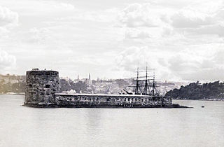
Fort Denison, part of the Sydney Harbour National Park, is a protected national park that is a heritage-listed former penal site and defensive facility occupying a small island located north-east of the Royal Botanic Garden and approximately 1 kilometre (0.62 mi) east of the Opera House in Sydney Harbour, New South Wales, Australia. The island is also known as Mattewanye or Muddawahnyuh in the Eora language, and as Pinchgut Island.

Bere Island or Bear Island is an island in Bantry Bay off the Beara Peninsula in County Cork, Ireland. It spans roughly 10 km x 3 km, with an area of 17.68 km2 and, as of the 2022 census, had a population of 218 people.

Harold Ainsworth Peto FRIBA was a British architect, landscape architect and garden designer, who worked in Britain and in Provence, France. Among his best-known gardens are Iford Manor, Wiltshire; Buscot Park, Oxfordshire; West Dean House, Sussex; and Ilnacullin, County Cork, Ireland.

The Beara Way is a long-distance trail in the southwest of Ireland. It is a 206-kilometre (128-mile) long circular trail around the Beara Peninsula that begins and ends in Glengarriff, County Cork, also passing through parts of County Kerry. It is typically completed in nine days. It is designated as a National Waymarked Trail by the National Trails Office of the Irish Sports Council and is managed by the Beara Tourism and Development Association.
Historic Cork Gardens of County Cork, Ireland.
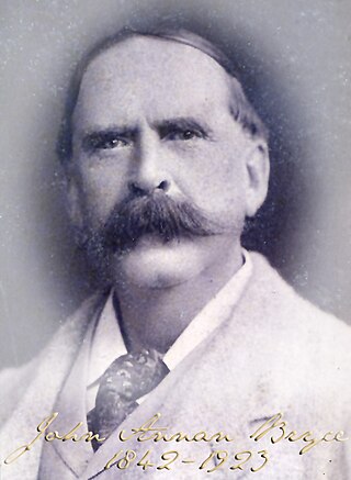
John Annan Bryce was a British businessman and Liberal Party politician.

Belvelly is a small village on the northern end of the Great Island of Cork Harbour, about four miles north of the town of Cobh, County Cork, Ireland. Belvelly is situated at the shortest crossing point between Great Island and the neighbouring Fota Island. Belvelly Bridge connects Great Island to Fota Island, which is in turn connected to the mainland near Carrigtwohill.

Long Island, historically called Inishfada, is an island that lies south of Schull, County Cork, Ireland. It has a permanent population of no more than 10. The island is named for being 4.8 km (3.0 mi)long and only 0.8 km (0.5 mi) wide. It is the third largest of Carbery's Hundred Isles at 1.8 km2 (0.7 sq mi), after Sherkin Island and Clear Island. The island’s most distinctive landmark is Copper Point lighthouse at its eastern end, marking the entrance to Schull Harbour.

Garinish is a privately owned island lying off the coast of the Iveragh Peninsula, County Kerry, Ireland.
29 Martello towers and battery installations were constructed or partially constructed in the Greater Dublin Area between 1803 and 1808. The towers were intended to act as a deterrent against a foreign invasion by Napoleon and his French Armies as well as being used as general lookout posts. In later years, towers were also used as coast guard stations, lookout stations to prevent smuggling and as other general purpose military installations by various British and Irish defence forces.


