29 Martello towers and battery installations were constructed or partially constructed in the Greater Dublin Area between 1803 and 1808. The towers were intended to act as a deterrent against a foreign invasion by Napoleon and his French Armies as well as being used as general lookout posts. [1] [2] [3] [4] In later years, towers were also used as coast guard stations, lookout stations to prevent smuggling and as other general purpose military installations by various British and Irish defence forces.
Contents
The Killiney bay towers were specifically planned following a 1797 survey by a Major La Chaussée who was employed by the British administration to survey the area and plot out points of weakness and potential locations for military defensive installations. [5]
| Number | Type | Image | Location | Council Area and County | Date | Ownership | Notes |
|---|---|---|---|---|---|---|---|
| 1 North | Tower | 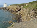 | Red Rock, Sutton 53°22′10″N6°05′50″W / 53.3695671°N 6.0970874°W | Fingal County Council, County Dublin | 1804 | Private dwelling house | At a key strategic point as it faced Sutton Creek which was often used by boats wishing to avoid the silted up harbour approaching the River Liffey mouth. It was also a deterrent to smugglers and acted as a general lookout post for the North Dublin Bay area. The tower also included a clay boundary ditch around the half acre site and 11 large boundary stones. [6] [7] [8] |
| 2 North | Tower |  | Howth East Pier 53°23′16″N6°03′54″W / 53.3878207°N 6.0650752°W | Fingal County Council, County Dublin | 1804 | Fingal County Council | Ye Olde Hurdy Gurdy Museum of Vintage Radio operates from the tower. Built on the site of an ancient Promontory fort complex. [8] [1] |
| 3 North | Double tower |  | Ireland's Eye 53°24′30″N6°04′13″W / 53.4082498°N 6.0701993°W | Fingal County Council, County Dublin | 1804 | Corporate Ownership | Acquired by Tetrarch Investment Group upon its acquisition of the Howth Estate in 2019. Access to the island is still open to the public [9] |
| 4 North | Tower |  | Carrickhill, Portmarnock 53°26′10″N6°07′20″W / 53.435976°N 6.122295°W | Fingal County Council, County Dublin | 1804 | Private dwelling house | [1] [10] |
| 5 North | Tower |  | Robswall, Malahide 53°26′52″N6°08′08″W / 53.447712°N 6.135609°W | Fingal County Council, County Dublin | 1805 | Private dwelling house | Often named Hick's Tower after the architect who extended and modernised the property as well as contributing its trademark conical shaped roof [8] [11] |
| 6 North | Tower |  | Balcarrick, Donabate 53°28′42″N6°06′55″W / 53.478328°N 6.115369°W | Fingal County Council, County Dublin | 1805 | Private ownership | The tower is derelict and vacant and in poor condition. [12] |
| 7 North | Tower |  | Tower Bay, Portrane 53°29′24″N6°05′50″W / 53.489900°N 6.097187°W | Fingal County Council, County Dublin | 1804 | Private dwelling house | In good and habitable condition. [13] |
| 8 North | Tower |  | Drumanagh, Loughshinny 53°32′26″N6°04′41″W / 53.540614°N 6.078161°W | Fingal County Council, County Dublin | 1804 | Private ownership | The tower is located on one of the most important archaeological sites in Ireland, It is vacant and derelict and in poor condition. [14] |
| 9 North | Tower |  | Rush 53°31′16″N6°04′35″W / 53.521038°N 6.076363°W | Fingal County Council, County Dublin | 1804 | Private dwelling house | Has been used as a main dwelling and as a holiday home in recent times [15] |
| 10 North | Tower | 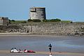 | Red Island, Skerries 53°35′05″N6°06′09″W / 53.584602°N 6.102461°W | Fingal County Council, County Dublin | 1804 | Fingal County Council | Vacant and derelict with windows and doors blocked up however it is still in moderately good condition owing to recent use as part of a holiday camp up until the 1980s. [16] |
| 11 North | Tower |  | Shenick Island, Skerries 53°34′25″N6°05′09″W / 53.573745°N 6.085723°W | Fingal County Council, County Dublin | 1805 | Fingal County Council | [17] |
| 12 North | Tower | | Balbriggan (Tankardstown) 53°36′58″N6°11′00″W / 53.615993°N 6.183294°W | Fingal County Council, County Dublin | 1804 | Fingal County Council | In extremely poor condition and the most at risk of any of the towers in the Dublin area. Previously in use as part of the adjacent coast guard station [18] |
| N/A North |  | Millmount Fort, Drogheda 53°42′42″N6°20′58″W / 53.711656°N 6.349517°W | Louth County Council, County Louth | 1808 | Charity (Old Drogheda Society) | [19] | |
| 1 South | Tower |  | Bray esplanade 53°12′05″N6°05′48″W / 53.201315°N 6.096604°W | Wicklow County Council, County Wicklow | 1804 | N/A - demolished | Demolished - various photos and drawings still exist showing the tower on the beach between the centre of the strand and Bray Head. |
| 2 South | Tower and battery |  | Bray on an elevated site guarding the south bank of the River Dargle 53°12′25″N6°06′06″W / 53.206826°N 6.101694°W | Wicklow County Council, County Wicklow | 1804 | Private dwelling house, battery demolished | Bono and Ali Hewson owned the property for a period in the 1980s. [8] [1] |
| 3 South | Tower |  | Townlands of Cork Great/Corke Abbey just north of the River Dargle 53°12′47″N6°06′07″W / 53.213058°N 6.101821°W | Dún Laoghaire–Rathdown County Council, County Dublin | 1804 | N/A - destroyed | Lost to coastal erosion and area currently lies circa 50m off the current shoreline submerged. Much of the stone has been taken for other uses in buildings around Bray although some of the large granite blocks remain submerged beneath the water. Marked on a map dated 1836. |
| 4 South | Tower and two batteries | No photo available | Maghera Point, Shankill near Bray 53°13′50″N6°06′26″W / 53.230605°N 6.107206°W | Dún Laoghaire–Rathdown County Council, County Dublin | 1804 | N/A - destroyed | Eroded but part of remains of the large granite blocks and boulders still lie strewn on the sea shore and surrounding area and can be seen on a clear day. Also included a defensive redoubt. Located close to Rosedale House which still stands as of 2020. The remains of the tower are clearly mapped on an OSI Map of 1897. Clear photos exist of the tower in the Lawrence collection prior to its collapse. |
| 5 South | Battery only | No photo available | Killiney (Shanganagh) 53°15′12″N6°06′50″W / 53.253271°N 6.113885°W | Dún Laoghaire–Rathdown County Council, County Dublin | 1804 | N/A - dismantled | Remains of the battery still can be seen near the shore. A Martello Tower was planned but never actually built or possibly only the foundations and part of the first floor were built before being dismantled or demolished in 1815. |
| 6 South | Tower and battery | No photo available | Killiney beach (Loughlinstown River) 53°15′00″N6°06′46″W / 53.249872°N 6.112837°W | Dún Laoghaire–Rathdown County Council, County Dublin | 1804 | Private dwelling house, battery demolished | Enoch Tower - still in use with vertical floor additions added by Victor Enoch, a martello tower aficionado and prominent member of Dublin's Jewish Community who authored a book called The Martello Towers of Ireland |
| 7 South | Tower and battery |  | Killiney Hill (Tara Hill) 53°15′23″N6°07′06″W / 53.256391°N 6.118252°W | Dún Laoghaire–Rathdown County Council, County Dublin | 1804 | Private dwelling house with battery restored | Enfilade tower [1] [20] |
| 8 South | Battery only | No photo available | Ballybrack/Limekiln, site of old Killiney Railway Station 53°15′33″N6°06′46″W / 53.259201°N 6.112837°W | Dún Laoghaire–Rathdown County Council, County Dublin | 1804 | N/A - demolished | Removed c.1853 for the construction of the railway line although some out buildings remained up until the 1960s. Much of the stone was used to build a tunnel under the railway line to the beach. |
| 9 South | Double tower and battery |  | Dalkey Island 53°16′18″N6°05′06″W / 53.271569°N 6.085130°W | Dún Laoghaire–Rathdown County Council, County Dublin | 1804 | Dún Laoghaire–Rathdown County Council | Both tower and battery still standing and in moderate condition as of 2020. [1] |
| 10 South | Tower | No photo available | Bullock Harbour/Bartra, Harbour Road, Dalkey 53°17′00″N6°06′13″W / 53.283322°N 6.103696°W | Dún Laoghaire–Rathdown County Council, County Dublin | 1804 | Private dwelling house | Listed for sale in 2016 at €1.8m after extensive renovations by architect Simone Stephenson and eventually sold for €1.78m. [21] [22] |
| 11 South | Tower and battery |  | James Joyce Tower and Museum, Sandycove 53°17′19″N6°06′49″W / 53.288666°N 6.113625°W | Dún Laoghaire–Rathdown County Council, County Dublin | 1804 | Museum | Well used museum and event space in excellent condition near to the Forty Foot. [8] [1] |
| 12 South | Tower and battery | 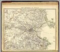 | People's Park, Dún Laoghaire/Glasthule 53°17′24″N6°07′39″W / 53.290039°N 6.127494°W | Dún Laoghaire–Rathdown County Council, County Dublin | 1804 | N/A - demolished | Demolished and the rubble was used to fill in a nearby quarry. The Tower was located on a high rocky outcrop in the corner of People's Park above a lower battery located on Scotsman's Bay. The tower was removed sometime around 1850 possibly due to undermining from quarrying and the need for stone in the area. Its position is clearly identified on an 1837 map of Dublin and Environs where it is called Glassdool Tower. |
| 13 South | Tower and battery | No photo available | Dún Laoghaire Harbour 53°17′40″N6°08′14″W / 53.29457°N 6.13716°W | Dún Laoghaire–Rathdown County Council, County Dublin | 1804 | N/A - demolished | Removed c.1836 for the construction of the Railway Line. It was not in the way of the railway line but possibly was destabilised and undermined following quarrying of material in the immediate vicinity of the tower. When the harbour was expanded the remaining fragments were finally removed. |
| 14 South | Tower | 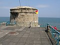 | Seapoint 53°17′52″N6°09′35″W / 53.297849°N 6.159815°W | Dún Laoghaire–Rathdown County Council, County Dublin | 1803 | Dún Laoghaire–Rathdown County Council | Formerly the headquarters of the Genealogical Society of Ireland and now used as changing rooms for the beach. |
| 15 South | Double tower |  | Blackrock/Booterstown (Williamstown) 53°18′24″N6°11′19″W / 53.306537°N 6.188563°W | Dún Laoghaire–Rathdown County Council, County Dublin | 1804 | Dún Laoghaire–Rathdown County Council | In moderate condition and due to be restored and brought into commercial and community use. |
| 16 South | Double tower |  | Sandymount Strand 53°19′31″N6°12′25″W / 53.325196°N 6.206892°W | Dublin City Council, County Dublin | 1804 | Private ownership | Dublin City Council have expressed an interest in acquiring the tower. Significant additions and extensions were made in the 1990s and 2000s to bring the tower into use as a restaurant, café and craft brewery [23] |