Sutton, Dublin

Last updated

Sutton
Irish: Cill Fhionntain
Suburb
Sutton Cross - geograph.org.uk - 458344.jpg
Sutton Cross
Location map Ireland County Dublin.png
Red pog.svg
Sutton
Location in Ireland
Ireland adm location map.svg
Red pog.svg
Sutton
Sutton (Ireland)
Dublin map.png
Red pog.svg
Sutton
Sutton (Dublin)
Coordinates: 53°23′10″N6°06′00″W / 53.38611°N 6.10000°W / 53.38611; -6.10000
Country Ireland
Province Leinster
County Dublin
Administrative County Fingal
Population
 (2016)
  Total5,680

Sutton (Irish : Cill Fhionntain, meaning "Fintan's cell or church") [1] is a residential suburb on the Northside of Dublin, Ireland. It occupies the tombolo which links Howth Head to the mainland, some of the lower slopes of Howth Hill, and a little of the adjacent coasts. The area lies within the jurisdiction of Fingal County Council. There is a small commercial core at the Sutton Cross road intersection.

Contents

Sutton lies in the ancient Barony of Coolock, within the traditional County Dublin.

History

The first recorded mention of Sutton in reference to the area is from around 1228–48, noted in the Calendar of Archbishop Alen's Register; it is likely linked to a person of Norman origin. [2] [3]

Location and geography

Marine Hotel, Sutton Cross Marine Hotel, Sutton Cross - geograph.org.uk - 458348.jpg
Marine Hotel, Sutton Cross

Location

Historically Sutton lay entirely on the Howth peninsula, from Sutton Cross up to Claremont Road and where Barren Hill meets Carrickbrack Road and the Martello Tower at Red Rock. Today, however, it is generally considered to extend to the railway, where it meets Baldoyle, and to the junction of Baldoyle Road and the coast road, where it meets Bayside, these additional lands historically having been farmland. The only neighbouring district on Howth Head is Howth itself.

Access

Beginning on the Howth Road (R105) about 12 kilometres from the city centre, Sutton neighbours Howth, which occupies most of the Howth peninsula, and Baldoyle and Bayside. It is served by the main road from Dublin to Howth (R105). Dublin Bus serves the area with routes H3 and 6, within the BusConnects scheme. There is a cycleway that connects Sutton to Clontarf and Fairview, with works ongoing to connect to Sandymount. [4]

Sutton railway station [5] opened on 30 July 1846 [6] as Baldoyle & Sutton, being renamed Sutton in 1901. The station lies on the Howth branch of the commuter rail network and is served by the Dublin Area Rapid Transit (DART) system.

The Hill of Howth Tramway ran between Sutton railway station and Howth railway station around the Hill of Howth until 1959.

The cycleway at Sutton works are ongoing to connect it to Sandymount Sutton Strand - geograph.org.uk - 458398.jpg
The cycleway at Sutton works are ongoing to connect it to Sandymount

Geography

At the core of Sutton is a tombolo connecting Howth (which used to be an island) to the mainland. The original village of Sutton was situated on the city-facing (south-western) side of Howth Head,[ citation needed ] along Strand Road, where there are today housing terraces and a small harbour, but the area is now centred on Sutton Cross.

Strand Road coastal pathway and Lui na Greine standing stone in the distance Sutton Creek - geograph.org.uk - 458373.jpg
Strand Road coastal pathway and Luí na Gréine standing stone in the distance

Streams

There are several small streams in the area, all substantially culverted. Some tiny flows cross the Sutton end of the Cliff Walk paths, and two bigger streams, Santa Sabina Stream and the Carrickbrack Stream, discharge at the coast on Sutton Strand. [7] :8 Carrickbrack Stream rises between Shielmartin Hill and Dun Hill near Howth Golf Course, and flows, meeting minor tributaries, roughly parallel to Carrickbrack Road, coming to the shore at the south-western end of the strand, [7] :8 while Santa Sabina Stream comes from the central area of the Howth (Deer Park) Estate, and runs in culvert past the Offington housing estate and through the grounds of Santa Sabina Dominican Convent, reaching the sand around 150m north of the mouth of the Carrickbrack, [7] :8 with concrete framing and a guard rail. The Santa Sabina outfall, in front of Saint Fintan's Roman Catholic church, sometimes flows very actively but is notably sometimes covered by sand, which is then cleared by Fingal County Council staff. [8] :23

Beaches

Burrow Beach at Sutton, Dublin, looking north towards Lambay Island Sutton beach1.jpg
Burrow Beach at Sutton, Dublin, looking north towards Lambay Island

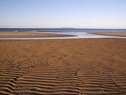
Sutton is surrounded by many beaches. The Burrow Beach is particularly popular among locals and tourists. It is approximately 1.2 km and stretches from Sutton Golf Club to Howth, along one side of the tombolo connecting Howth Head to the mainland. [9] Sutton Strand runs along the coast road and in front of St. Fintan's church.

Quarries

Two quarries previously operated in Sutton on the Howth Road near Corr Castle and at Barren Hill on St.Fintans Road. Both are now closed. [10]

Amenities

There is one main commercial area, with a Supervalu store (previously a Superquinn) supermarket, under that chain's HQ, which in turn had replaced the local cinema), the Marine Hotel, a post office, and other banking, dining and retail operations. The local filling stations closed some years back,[ when? ][ citation needed ] leaving the unattended Maxol filling station in coastal Kilbarrack and its attended station on Baldoyle Road as the only fuelling facilities nearby.

Sutton as seen from Howth Head. Sutton from howth.jpg
Sutton as seen from Howth Head.

Sports and leisure activities

There is dinghy sailing off the coast at Sutton Dinghy Club, based within Sutton Creek. [11] Golf can be played at Sutton Golf Club, with Howth and the Deerpark golf facilities nearby; footgolf and poc fada can also be played at Deerpark. Suttonians Rugby Football Club, at Station Road, provides for local rugby players and supporters. Sutton Tennis Club has 12 outdoor courts and five indoor squash courts; it is the biggest club for junior squash in Ireland. [12] The local soccer club is Howth Celtic, with grounds located opposite St.Fintan's primary school on Carrickbrack Road. There is a local scout group which meets in St. Mary's Church of Ireland Parish Hall in Howth.[ citation needed ]

Red Rock is a trailhead for the Cliff Walk which navigates a large section of Howth Head and ends at Howth village. Shielmartin Hill is also readily accessible from Sutton.

Buildings

Santa Sabina Manor Housing estate on Carrickbrack Road Howth Housing - geograph.org.uk - 458367.jpg
Santa Sabina Manor Housing estate on Carrickbrack Road

One of the area's oldest buildings, the fifteenth century Corr Castle, is located at Sutton North near the Howth Road entrance to Offington housing estate. The castle previously formed part of the Howth Park Racecourse which stretched over large parts of Sutton and Howth.

The area is also home to one of Ireland's Martello Towers at Red Rock which is now a private residence. Also located in Red Rock is Sutton Castle, the former home of the Jameson family, and later became the residence of Belgian businessman Albert Luykx, made famous during the Irish arms trial. It subsequently became Sutton House Hotel and then Sutton Castle Hotel, before being converted in 2003 to private residences. [13] [14]

Several notable Georgian houses are located in Sutton including two imposing 4-storey Georgian era houses now called Beachfield House (previously called Devonshire Terrace) as well as the nearby Sealawn House (1830s) which was owned by John Pentland Mahaffy. Adjacent to these is a terrace of Howth stone-faced fisherman's cottages called Martello Terrace. The end house of this terrace used to house the old Sutton coast guard station but has now been converted into residential accommodation. [15]

The old tram shed which was used by the Hill of Howth Tramway is located near Sutton Station, but is now a private residence which is part of a modern housing development. [16]

The Luí na Gréine (English:Sunset) granite standing stone monument is located on the seaside pathway at Sutton strand and was designed by Cliodhna Cussen and erected in the mid-2000s.

Education

Sutton has three mixed primary schools: the Burrow School, on the Dublin Road between Sutton Cross and Howth, St. Fintan's National School, on Carrickbrack Road, and the primary part of Sutton Park School. It holds three secondary schools: St. Fintan's High School (a boys school, technically in Baldoyle), Santa Sabina Dominican College [17] (a.k.a. Santa Sabina) (girls) and the senior part of Sutton Park School (mixed).

Religion

Sutton comprises a parish in the Roman Catholic church, St. Fintans, within the deanery of Howth, with a parish church [18] [19] at the base of Howth Hill, adjacent to Santa Sabina School, at the junction of Greenfield Road and Church Road.

St.Fintans church St Fintan's Church - geograph.org.uk - 458357.jpg
St.Fintans church

There is also a Methodist church [20] at the junction of Church Road and Howth Road.

Sutton Methodist Church Sutton Methodist Church - geograph.org.uk - 518809.jpg
Sutton Methodist Church

Sutton contains one of Dublin's main burial grounds, St. Fintan's, which is divided into two parts, "old" and "new." The former contains a ruined chapel dating from early Norman times, and the latter, an abandoned keeper's cottage. [21]

Uphill from the older graveyard, in a wooden hut on private grounds, is the still-flowing holy well of St. Fintan. [22]

Administration

Sutton is part of the Dublin Bay North Dáil Éireann constituency, having previously been part of Dublin North-East for many years.

The area is also within the Howth-Malahide local electoral area in the jurisdiction of Fingal County Council, and there is also an electoral division of Sutton.

Notable people

See also

Related Research Articles

<span class="mw-page-title-main">Northside, Dublin</span> Informal division of Dublin, Ireland

The Northside in an informal but commonly used term to describe the part of the city of Dublin that lies to the north of the River Liffey, and extending into part of North County Dublin. The part outside the city is within the county of Fingal, a local government area established in 1994. While it is sometimes regarded as less wealthy than the city's Southside, the Northside was originally the home of the city's upper classes and the more privileged of the two. Today, some of the wealthiest areas in Ireland, such as Malahide, Howth, Clontarf, and Castleknock, lie north of the river.

<span class="mw-page-title-main">Malahide</span> Suburban settlement north of Dublin, Ireland

Malahide is an affluent coastal settlement in Fingal, County Dublin, Ireland, situated 14 kilometres (9 mi) north of Dublin city. It has a village centre surrounded by suburban housing estates, with a population of 18,608 as per the 2022 census.

<span class="mw-page-title-main">Howth</span> Peninsular suburb of Dublin

Howth is an affluent peninsular village and outer suburb of Dublin, Ireland. The district as a whole occupies the greater part of the peninsula of Howth Head, which forms the northern boundary of Dublin Bay, and includes the island of Ireland's Eye, which holds multiple natural protection designations.

<span class="mw-page-title-main">Howth Head</span> Peninsula northeast of Dublin, Ireland

Howth Head is a peninsula northeast of the city of Dublin in Ireland, within the governance of Fingal County Council. Entry to the headland is at Sutton while the village of Howth and the harbour are on the north-eastern face. Most of Howth Head is occupied by the Hill of Howth, though there are other regions, such as the tombolo at Sutton, extensive beaches on the northern shores, and small ones in other parts. The Baily Lighthouse is on the southeastern part of Howth Head. Nearby are the districts of Baldoyle and Portmarnock, and adjacent is the nature reserve of North Bull Island.

<span class="mw-page-title-main">Baldoyle</span> Coastal north-eastern suburb of Dublin, Ireland

Baldoyle is a coastal suburb of Dublin's northside. It is located in the southeastern part of the jurisdiction of Fingal, Ireland, developed from a former fishing village.

Bayside is a small residential suburb on the Northside of Dublin, Ireland, purpose-built from 1967 on lands previously part of Kilbarrack. It has a planned central service area with retail facilities and lies inshore of Bull Island. It absorbed a neighbouring development, Sutton Park, Dublin, also on Kilbarrack lands adjacent to Baldoyle. Established under Dublin Corporation, it was later moved to the jurisdiction of Fingal County Council.

<span class="mw-page-title-main">Hill of Howth Tramway</span> Tram which served Howth Head, Ireland

The Howth Tram on the Hill of Howth Tramway was a tram which served Howth Head, near Dublin, Ireland. The termini were at Sutton railway station, by the entrance to the peninsula, and Howth railway station by the village and harbour of Howth.

Kilbarrack is a residential suburb of Dublin, Ireland, running inwards from the coast, about 8 km (5.0 mi) from the city's centre. It is also a civil parish in the ancient barony of Coolock. Modern-day Kilbarrack is within the jurisdiction of Dublin City Council, with part of its old lands now in Donaghmede, and part in Bayside under Fingal County Council jurisdiction.

<span class="mw-page-title-main">Howth Castle</span> Castle within demesne at Howth, near Dublin, Ireland

Howth Castle and estate lie just outside the village of Howth, County Dublin in Ireland, in the administration of Fingal County Council. The castle was the ancestral home of the line of the St Lawrence family that had held the area since the Norman Invasion of 1180, and held the title of Lord of Howth until circa 1425, the Baron Howth to 1767, then Earl of Howth until 1909. The castle and estate are held since 1909 by their distaff heirs, the Gaisford-St Lawrence family.

<span class="mw-page-title-main">Sutton railway station (Ireland)</span> DART (rail) station in Dublin

Sutton railway station is a railway station in Fingal, Ireland that serves the village and district of Sutton, and is also accessible from Baldoyle.

<span class="mw-page-title-main">Shielmartin Hill</span> Peak on Howth Head near Dublin, Ireland

Shielmartin Hill or Shelmartin is a peak on Howth Head. From it can be seen Portmarnock, Sutton, Bull Island and the coastal areas behind it, and most of Dublin Bay.

<span class="mw-page-title-main">Carrickbrack Road</span> Road on Howth Head, Dublin

Carrickbrack Road is a road in Dublin, Ireland, a constituent part of the R105 Regional Road. It leads east-southeast from Sutton Creek around the southern part of Howth Head, up to the eastern part of the headland near Howth Summit, to Thormanby Road. It is the main thoroughfare through the southern part of the headland. Greenfield Road links it to Sutton Cross. Howth Golf Club is located on it, as are Bellingham’s farm, Howth Celtic Football Club, St. Fintan's Cemetery, St. Fintan's National School and various private residences.

<span class="mw-page-title-main">St. Fintan's Cemetery, Sutton</span> Cemetery in Sutton, Dublin, Ireland

St. Fintan's Cemetery is located in Sutton, on the south side of Carrickbrack Road in Dublin, Ireland. It is in several sections: original with a ruined keeper's cottage and the remnants of old St. Fintan's Church, 1889, 1907 and 1954 extensions, and St. Fintan's Lawn Cemetery divided to St. Marnoc's, St. Assam's, St. Barroc's, St. Nessan's a St. Polan's. Just beyond the older portion is the still-flowing, still-visited St. Fintan's Holy Well.

<span class="mw-page-title-main">St. Fintan's High School</span> Secondary school for boys, Dublin, Ireland

St. Fintans High School is an all-boys Roman Catholic voluntary-aided secondary school located between Sutton and Baldoyle, Dublin, Ireland.

<span class="mw-page-title-main">R105 road (Ireland)</span> Regional road in North Dublin

The R105 road is a regional road in north Dublin, Ireland. It travels from the city centre to Howth, and loops at both ends; the road fully encircles Howth Head. Along the way, the road passes through Fairview, the western end of Clontarf, Killester, Raheny, the coastal edge of Kilbarrack and Sutton. Its biggest component is Howth Road.

<span class="mw-page-title-main">Baldoyle Bay</span> Sea inlet and nature reserve north of Dublin, Ireland

Baldoyle Bay is a sea inlet on the east coast of Fingal in Ireland, in the traditional County Dublin. It is situated between Portmarnock, at its head, and Baldoyle. It contains two small estuaries, those of the Sluice River and the Mayne River, and is sometimes called Baldoyle Estuary. The inlet is an important natural feature with protected status. It was once the site of a Viking longphort and later the fishing village of Baldoyle developed near its outlet to the sea.

<span class="mw-page-title-main">James McCormack (Irish revolutionary)</span> Irish activist and revolutionary (1877–1916)

James McCormack (1877–1916) was an Irish activist & revolutionary who, as part of the Irish Citizen Army, fought and died in the Easter Rising of 1916.

<span class="mw-page-title-main">Burrow Beach</span> Strand on Howth Head, County Dublin

Burrow Beach, also known as the Hole in the Wall locally, is a beach in Sutton, in Fingal, County Dublin, Ireland. It neighbours Claremont Beach by Howth village, and, across the water, Portmarnock Strand. It is served by a lifeguard during the summer months and is a green flag beach.

<span class="mw-page-title-main">Sutton Castle, Dublin</span> Castellated mansion house

Sutton Castle or Sutton House is a Victorian Tudor-style castellated mansion house with terraced gardens on the southern coast of Howth Head, overlooking Dublin Bay, in the suburbs of Dublin, Ireland.

<span class="mw-page-title-main">Corr Castle</span> Tower house in Sutton, Dublin

Corr Castle is an L-plan tower house likely constructed sometime in the fifteenth century in Sutton, Dublin. The castle lies within the boundaries of Howth Demesne in the old townland of Correston, close to the townlands of Quarry and Burrow. The castle was probably built on higher ground in order to guard the isthmus at Sutton which was the only route on land to access Howth Castle and the port of Howth. It has historically sometimes been called The Dane's castle.

References

  1. Logainm- Placename database of Ireland. "Cill Fhionntáin". Archived from the original on 6 January 2018. Retrieved 5 January 2018.
  2. "Cill Fhionntain Theas/Sutton South". logainm.ie. Retrieved 28 October 2022.
  3. "Alen Register by Church of Ireland - Issuu". issuu.com. 19 June 2019. Retrieved 28 October 2022.
  4. Lyne, Laura (5 May 2017). "Latest phase of Sutton to Sandycove cycleway opened by Lord Mayor in Clontarf". Dublin Live. Archived from the original on 15 November 2017. Retrieved 14 November 2017.
  5. Archiseek web page on Sutton Railway station Archived 6 October 2008 at archive.today
  6. "Baldoyle and Sutton station" (PDF). Railscot – Irish Railways. Archived (PDF) from the original on 26 September 2007. Retrieved 3 September 2007.
  7. 1 2 3 Doyle, Joseph W. (2013) [2008]. Ten Dozen Waters: The Rivers and Streams of County Dublin (7th ed.). Dublin, Ireland: Rath Eanna Research. ISBN   978-0-9566363-6-2.
  8. Doyle, Joseph W. (2022) [2022]. The Rivers and Streams of Dublin (City of Dublin, Fingal, South Dublin and Dún Laoghaire-Rathdown) (2nd ed.). Dublin, Ireland: Rath Eanna Research. ISBN   978-0-9566363-9-3.
  9. Council, Fingal County. "The Burrow beach : : Fingal County Council". fingalcoco.ie. Archived from the original on 1 December 2016. Retrieved 1 December 2016.
  10. "CORR CASTLE WITH MACHINERY AND WORKMEN". edwindavison.com. Archived from the original on 19 July 2021. Retrieved 29 May 2020.
  11. "Brief History". sdc.ie. Archived from the original on 23 July 2020. Retrieved 23 July 2020.
  12. "Sutton Lawn Tennis Club". suttonltc.com. Archived from the original on 1 November 2020. Retrieved 24 September 2021.
  13. "1880 – Sutton Castle Hotel, Sutton, Co. Dublin". archiseek.com. 28 January 2010. Archived from the original on 15 November 2017. Retrieved 14 November 2017.
  14. "Luxury living at Sutton Castle apartments". Business Post . 2 July 2005. Archived from the original on 15 November 2017. Retrieved 14 November 2017.
  15. Lyons, Madeleine. "Slick Sutton coastguard station transformation for €995,000". irishtimes.com. Archived from the original on 12 December 2018. Retrieved 29 May 2020.
  16. "The Hill of Howth Tramway and tram No. 9". National Transport Museum of Ireland. Archived from the original on 5 October 2017. Retrieved 14 November 2017.
  17. "Santa Sabina Dominican College". Archived from the original on 2 March 2021. Retrieved 24 September 2021.
  18. "Archiseek page on St. Fintans' Roman Catholic Church". Archived from the original on 3 March 2016. Retrieved 8 February 2010.
  19. "Photo of St. Fintans' Church". Archived from the original on 20 October 2017. Retrieved 7 December 2017.
  20. "Photo of Sutton Methodist Church". Archived from the original on 20 October 2017. Retrieved 7 December 2017.
  21. "Saint Fintan's Church, Carrickbrack Road, SUTTON SOUTH, Sutton, DUBLIN". Buildings of Ireland. Retrieved 28 October 2022.
  22. "Holy Well: Saint Fintan's Well, Sutton, County Dublin". Archived from the original on 15 November 2017. Retrieved 14 November 2017.
  23. 1 2 O'Hare, Colm. "At Home With Philomena Lynott". Hotpress. Retrieved 25 September 2023.
  24. White, Lawrence William. "Perolz, Mary (Máire, Marie)". Dictionary of Irish Biography.
  25. Egan, Barry (13 December 2013). "Vogue McFadden: Brian is all I could have wished for". Irish Independent . Archived from the original on 5 January 2018. Retrieved 5 January 2018.