Irishtown grew outside of Dublin, about 2km east of the medieval city walls (see also Ringsend). Dublin was originally a Viking city and after 1171, when an Anglo-Norman army seized it, Dublin became the centre of English rule in Ireland. The native Gaelic Irish were therefore viewed as an alien force in the city, and suspicion of them was deepened by continual raids on Dublin and its environs by the O'Byrne and O'Toole clans from the nearby Wicklow Mountains. By the 15th century, Gaelic migration to the city had made the English authorities fearful that the English language and culture would become a minority there. As a result, the Irish inhabitants of Dublin were expelled from the city proper in about 1454, in line with the Statutes of Kilkenny. The Irish population were only allowed to trade inside the city limits by daylight. At the end of the day's trading, they would leave and set up camp in what was to become known as "the Irishtown".
In 1794 Richard Power, judge of the Court of Exchequer, who was facing charges of corruption, drowned himself in the river at Irishtown.
At the end of the 19th century and into the early 20th century, Irishtown was the location of the Waxies' Dargle, an annual outing by Dublin cobblers ("waxies"), which a well-known folk song recalls.[1]
Irishtown formed part of the Pembroke Township created in 1863. Pembroke was redesignated an urban district in 1899, before being abolished and brought into the jurisdiction of the city in 1930.[2]
Map of Irishtown (with Ringsend & Sandymount) with notable buildings.
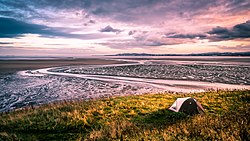
Irishtown Nature Park
Poolbeg Power Station from Irishtown nature park
Irishtown Nature Park is a small park with a walkway which offers several kilometres of walking trails along the Poolbeg Peninsula.
This page is based on this Wikipedia article Text is available under the CC BY-SA 4.0 license; additional terms may apply. Images, videos and audio are available under their respective licenses.