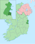
Goatstown

Last updated

Goatstown
Baile na nGabhar
Suburb
The Goat Grill, Goatstown, Co. Dublin.jpeg
The Goat Grill
Dublin map.png
Red pog.svg
Goatstown
Location in Dublin
Ireland adm location map.svg
Red pog.svg
Goatstown
Goatstown (Ireland)
Coordinates: 53°17′35″N6°13′48″W / 53.293°N 6.230°W / 53.293; -6.230
Country Ireland
Province Leinster
County Dún Laoghaire–Rathdown
Time zone UTC+0 (WET)
  Summer (DST) UTC-1 (IST (WEST))
Eircode routing key
D14
Telephone area code +353(0)1

Goatstown (Irish : Baile na nGabhar) is a small Southside suburb of Dublin, Ireland. To the west is Dundrum, to the east is Blackrock, to the south is Kilmacud, and to the north is Clonskeagh. The area is bordered by Mount Merrion to which it shares many local amenities. Entrances to University College Dublin can be found on Roebuck Road, and due to the areas proximity to the campus, the suburb is highly attractive to university students. It is mainly a residential area, with a primary school called Our Lady's Grove, and two all-girls secondary schools, Mount Anville Secondary School and Our Lady's Grove Secondary School (Previously called Jesus and Mary). There are amenities such as restaurants, a pub, a post office and various shops. With the recent implementation of the frequent S6 bus route to Blackrock via UCD Belfield recently, the area now benefits from connection to the DART line, as well as being served by the 11 Dublin Bus route through the centre of the village.

Contents

Nature

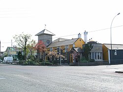
Goatstown is primarily a residential area, with extensive housing developments from the middle decades of the 20th century onwards, with little local industry. It is roughly centred on a pub named the Goat Grill, at the intersection of Goatstown Road and Taney Road, where there has been a pub since the early 18th century.

Etymology

Goatstown got its name from the fact that formerly goats were bred there; in the 19th century it was popular to travel to Dundrum and nearby Goatstown as goat's milk was considered to be excellent for those suffering from tuberculosis. [1] [2]

Transport

A number of roads pass through Goatstown. At the crossroads the R112 passes from west (Taney Road) to east (Mount Anville Road), to the south is the R825 (Goatstown Road) and to the north is the R133 (Lower Kilmacud Road). A short distance from the crossroads is a T-junction where the R826 terminates at the R112 on Taney Road.

The Luas green line runs through the southwest corner of Goatstown and the Dundrum stop is nearby, with the vehicular entrance off Taney Road, as is Balally at Drummartin Road.

The bus routes Dublin Bus 11, 11a and L25 and Go-Ahead Ireland S8 run through Goatstown as well, linking Goatstown to the city centre, Dún Laoghaire and Tallaght. The 75 used to run through Goatstown until 26 November 2023 when it was replaced with the L25.

Development

To the east of the Goatstown Road lies former allotment land, much of which was compulsorily purchased during the 1960s for the proposed Eastern Bypass / Saint Helen's link road. A portion of this land is currently being built on by Dún Laoghaire–Rathdown County Council, to provide social and affordable housing.[ citation needed ]

A Georgian house and remaining surrounding land, known as Trimbleston, was sold in the early 1990s to builders Sorohan Brothers. The house was subsequently damaged in two fires and the remaining ruins were demolished and replaced by a housing and apartment development, also called Trimbleston. Phase two of Trimbleston has recently commenced with the demolition of five two-storey houses on Goatstown Road and the construction of 202 dwelling units in their place and on land to the east owned by the Sorohans.

Notable people

Notable events

Charlie Chawke, who took over the local pub in 1982 and changed the name from Traynor's to the Goat Grill, was shot in the leg in October 2003 in a robbery and had his right leg amputated five days later. [4]

In another widely publicised case, on 5 March 2008, a jury found Brian Kearney guilty of the murder of his wife, Siobhán Kearney, at their home in Cnoc na Sí, Goatstown in February 2006. [5]

See also

Related Research Articles

<span class="mw-page-title-main">Blackrock, Dublin</span> Suburb of Dublin in Dún Laoghaire-Rathdown, Ireland

Blackrock is a suburb of Dublin, Ireland, 3 km (1.9 mi) northwest of Dún Laoghaire. It is named after the local geological rock formation to be found in the area of Blackrock Park. In the late 18th century, the Blackrock Road was a common place for highway robberies. The Blackrock baths, provided for by the railway company in 1839, became popular in the 19th century but Blackrock is now a tourist destination.

<span class="mw-page-title-main">Southside, Dublin</span> Informal region in Dublin, Ireland

The Southside is the part of Dublin city that lies south of the River Liffey. It is an informal but commonly used term. In comparison to the city's Northside, it has historically been regarded as wealthier and more privileged, with several notable exceptions.

<span class="mw-page-title-main">Dún Laoghaire–Rathdown</span> County in Ireland

Dún Laoghaire–Rathdown is a county in Ireland. It is in the province of Leinster and the Eastern and Midland Region. It is one of three successor counties to County Dublin, which was disestablished in 1994. It is named after the former borough of Dún Laoghaire and the barony of Rathdown. Dún Laoghaire–Rathdown County Council is the local authority for the county. The population of the county was 233,860 at the time of the 2022 census.

<span class="mw-page-title-main">Stillorgan</span> Suburb of Dublin, in Dún Laoghaire–Rathdown, Ireland

Stillorgan, formerly a village in its own right, is now a suburban area of Dublin in Ireland. Stillorgan is located in Dún Laoghaire–Rathdown, and contains many housing estates, shops and other facilities, with the old village centre still present. Stillorgan is at least partly contiguous with Kilmacud and neighbours other southside districts such as Mount Merrion, Sandyford, Leopardstown, Dundrum, Blackrock, Goatstown and Foxrock.

<span class="mw-page-title-main">Dundrum, Dublin</span> Suburb of Dublin, Ireland

Dundrum, originally a village in its own right, is an outer suburb of Dublin, Ireland. The area is located in the postal districts of Dublin 14 and Dublin 16. Dundrum is home to the Dundrum Town Centre, the largest shopping centre in Ireland.

Mount Merrion is a suburb of Dublin, Ireland. It is roughly 7 kilometres (5 mi) south of Dublin city centre and is situated on and around the hill of the same name.

Nutgrove is an area in Churchtown, County Dublin.

<span class="mw-page-title-main">Stepaside, Dublin</span> Suburban village on outskirts of Dublin, Ireland

Stepaside is a village in the townland of Kilgobbin, located in south County Dublin, in Dún Laoghaire–Rathdown, Ireland. The area is 4 kilometres (2.5 mi) south of Dundrum.

<span class="mw-page-title-main">N31 road (Ireland)</span> Road in Ireland

The N31 road is a national primary road in Ireland. It connects the harbour at Dún Laoghaire southeast of Dublin to the national route network. Both the N11 and Dublin's M50 C-ring motorway connect to the N31.

<span class="mw-page-title-main">Cornelscourt</span> Suburb of Dublin, Ireland

Cornelscourt is a small suburban area within the traditional County Dublin, now in the jurisdiction of Dún Laoghaire–Rathdown. Situated between Cabinteely, Carrickmines and Foxrock, it is a primarily residential area, but is perhaps best known for being the site of Ireland's first big-box store, a branch of Dunnes Stores, and the country's first drive-through bank.

<span class="mw-page-title-main">Loughlinstown</span> Outer suburb of Dublin, Ireland

Loughlinstown is a southern Dublin suburb, located in Dún Laoghaire–Rathdown, on the N11 national road.

<span class="mw-page-title-main">Kilmacud</span> Suburb of Dublin, Ireland

Kilmacud is a suburban area of Dublin in Dún Laoghaire–Rathdown, Ireland, at least partly contiguous with Stillorgan.

<span class="mw-page-title-main">R112 road (Ireland)</span> Suburban road between Chapelizod and Mount Merrion in Dublin, Ireland

The R112 road is a regional road in south Dublin, Ireland. It begins at the junction with the R148 road at Chapelizod and arcs southeastwards, then eastwards across the middle of south Dublin, ending at the Mount Merrion junction of the R138. The road is a single carriageway, with cycle lanes on some stretches. Improvements to the road have been made over the last 10 years, the most significant being at Dundrum Cross where the road was widened to make room for the new Luas bridge and Dundrum bypass.

<span class="mw-page-title-main">R825 road (Ireland)</span> Regional road in south Dublin, Ireland

The R825 road is a regional road in south Dublin, Republic of Ireland. The road starts in Clonskeagh at the junction with the R117 and passes through Goatstown, Kilmacud and Stillorgan before ending at a junction with the N31 in Blackrock, County Dublin. The route is 7.6 km (4.7 mi) in length and is single carriageway apart from a small 2 lane section beside the N11.

<span class="mw-page-title-main">R133 road (Ireland)</span> Regional road in south Dublin, Ireland

The R133 road is a regional road in south Dublin, Ireland. The road starts at Goatstown and runs in a southerly direction towards Sandyford before acting as a link road for the M50.

<span class="mw-page-title-main">R826 road (Ireland)</span> Regional road in south Dublin, Ireland

The R826 road is a regional road in south Dublin, Ireland. The road runs from the Dundrum junction of the M50 as passes through or near Ballinteer, Dundrum and Balally before terminating at the junction with the R112 close to Goatstown. The route runs on mostly new road, built to facilitate the M50 and Dundrum Town Center and is 2.5 km long.

Dublin Rathdown is a parliamentary constituency represented in Dáil Éireann, the lower house of the Irish parliament or Oireachtas, since the 2016 general election. The constituency elects three deputies on the system of proportional representation by means of the single transferable vote (PR-STV).

<span class="mw-page-title-main">Balally Luas stop</span> Tram stop in Dublin, Ireland

Balally is a stop on the Luas light-rail tram system in Dún Laoghaire–Rathdown, County Dublin, Ireland. It opened in 2004 as a stop on the Green Line and serves Dundrum Town Centre as well as the southern area of Dundrum and the nearby suburbs of Balally and Goatstown. The stop is located at the junction at the side of Overend Avenue.

<span class="mw-page-title-main">Dundrum Luas stop</span> Tram/light rail stop in Dublin, Ireland

Dundrum is a stop on the Luas light rail tram system in Dublin, Ireland which serves the suburb of Dundrum. It opened in 2004 as a stop on the Green Line, which re-uses the alignment of the Harcourt Street railway line which closed in 1958. Dundrum Luas stop is built on the same site as a former heavy rail station of the same name.

References

  1. Se n S illeabh in (1967), Irish folk custom and belief, Published for the Cultural Relations Committee of Ireland at the Three Candles, p. 24
  2. Royal Medical and Chirurgical Society of London (1902), The Climates and baths of Great Britain, Volume 2, Macmillan, p. 415
  3. William Dargan, Famous People of Ireland
  4. "Chawke gives evidence in robbery trial". RTÉ News. 20 June 2006. Retrieved 23 March 2008.
  5. "Brian Kearney given life sentence for murder of Siobhán". Irish Independent. 5 March 2008. Retrieved 1 April 2009.

External

County Council Map for proposed Goatstown Local Area Plan