In his 1903 work, A History of the County Dublin, the historian Francis Elrington Ball describes Milltown as being the "scene of industrial enterprise" from a "very early period" and that as "early as the fourteenth century the existence of a mill is mentioned".[3] Ball also states that "mediaeval quarrying operations carried on at Milltown" provided stone for repairs to Dublin's Christ Church Cathedral.[3]
By the 18th century, the area was home to several mills - including two corn mills, an iron mill and paper mill.[3] A former mill race was taken from just above the weir located 100m downstream from the Nine Arches Viaduct. It ran towards a mill which was located in what is now Dodder Park. The remnants of this mill can still be seen.[5]
Old Milltown Bridge, also known as Packhorse Bridge, reportedly dates to the 1600s
Historically used as a fording point on the River Dodder,[3] a bridge was built at Milltown in the 17th century.[6] This bridge, known as "(Old) Milltown Bridge" or "Packhorse Bridge", is recorded in the Record of Monuments and Places and classified as a protected structure.[7][8][9] A newer bridge was later built at Milltown,[9] and by the early 20th century the older structure was used only for pedestrian traffic.[3] The newer Milltown Bridge was built on the site of the former ford, which was in use up until at least the late 18th century.[3]
Transport
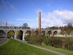
Milltown is marked by a landmark 19th-century railway bridge across the river, which was part of the Harcourt Street railway line which ran from Harcourt Street to Bray. This bridge, and sometimes the area immediately surrounding it, became known as the 'Nine Arches'. Milltown railway station opened on 1 May 1860 and finally closed on 31 December 1958.[10] On 30 June 2004, the bridge was re-opened for the Luas light rail system which runs from Broombridge to Bride's Glen. There is also a Luas stop a few yards north of the former station.
The area is still associated with Shamrock Rovers football club, who played there at Glenmalure Park on land leased from the Jesuits, from 1926 until 1987 when it was controversially sold to developers.[12][13] Milltown Golf Club celebrated its centenary in 2007.[14]
Administrative area
Milltown is located along the River Dodder, which in this area, marks the boundary between the two council areas of Dublin City Council and Dún Laoghaire–Rathdown County Council. Milltown lies in both, with the village falling within Dublin City.[15]
The Franciscan Brothers of the Third Order Regular, noted for their having secretly taught the boys of the Catholic population for decades in underground schools, had formed a monastery and school here, after the relaxation of the Penal Laws which had forbidden Catholic education. In 1818 they transferred their monastery to Mountbellew in County Galway.[16]
Mount St. Mary's was formerly the seminary of the Marist Fathers,[17] students for the priesthood would study theology with the Jesuits in Milltown Park, and also study for degrees in Arts or Science in UCD, while based in Mount St. Marys.
↑D'Alton, John (1838). The History of the County of Dublin. Dublin. p.685. In 1353 the king committed to William de Barton [..] the custody of one mill, one carucate, and fifty acres of land in Saggard, Milltown [..] and Kilmactalway
This page is based on this Wikipedia article Text is available under the CC BY-SA 4.0 license; additional terms may apply. Images, videos and audio are available under their respective licenses.