Finglas is a northwestern outer suburb of Dublin, Ireland. It lies close to Junction 5 of the M50 motorway, and the N2 road. Nearby suburbs include Glasnevin and Ballymun; Dublin Airport is seven km (4.3 mi) to the north. Finglas lies mainly in the postal district of Dublin 11.

Swords, the county town of Fingal, is a large suburban town on the east coast of Ireland, situated ten kilometres north of Dublin city centre. The town was reputedly founded c. AD 560. Located on the Ward River, Swords features Swords Castle, a restored medieval castle, a holy well from which it takes its name, a round tower and a Norman tower. Facilities in the area include the Pavilions shopping centre, one of the largest in the Dublin region, a range of civic offices, some light industries, the main storage facility and archive of the National Museum of Ireland and several parks. Dublin Airport is located nearby.

Dublin Bus is a State-owned bus operator providing services in Dublin. By far the largest bus operator in the city, it carried 138 million passengers in 2019. It is a wholly-owned subsidiary of Córas Iompair Éireann.

Bus Éireann is a state-owned bus and coach operator providing services throughout Ireland, with the exception of Dublin and the Greater Dublin Area, where bus services are provided by sister company Dublin Bus. It is a subsidiary of Córas Iompair Éireann (CIÉ). The company's primary hub is Busáras, Central Bus Station, located in Store Street, Central Dublin.
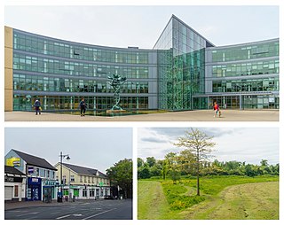
Blanchardstown is a large outer suburb of Dublin in the modern county of Fingal, Ireland. Located ten kilometres (6 mi) northwest of Dublin city centre, it has developed since the 1960s from a small village to a point where Greater Blanchardstown is the largest urban area in Fingal.
Holt Park is a medium-sized low-rise 1970s housing estate in the northwest suburbs of Leeds, West Yorkshire, England. It is approximately 6 miles (10 km) from Leeds city centre situated between Tinshill, Cookridge and Adel, and is at the edge of the Leeds urban fringe, bordering the green belt which makes up two thirds of the metropolitan borough of the City of Leeds. The nearby Tinshill BT Tower dominates the skyline.
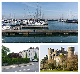
Malahide is an affluent coastal settlement in Fingal, County Dublin, Ireland, situated 14 kilometres (9 mi) north of Dublin city. It has a village centre surrounded by suburban housing estates, with a population of over 17,000.

Coolock is a large suburban area, centred on a village, on Dublin city's Northside in Ireland. Coolock is crossed by the Santry River, a prominent feature in the middle of the district, with a linear park and ponds. The Coolock suburban area encompasses parts of three Dublin postal districts: Dublin 5, Dublin 13 and Dublin 17.

Palmerstown is a civil parish and suburb in western Dublin on the banks of the River Liffey. It forms part of the South Dublin local authority and the Dublin Mid-West parliamentary constituency. The area is bordered to the north by the River Liffey and the Strawberry Beds, to the west by Lucan, to the south-west by Clondalkin, to the south by Ballyfermot and to the east by the village of Chapelizod. Palmerstown village is situated near the Liffey Valley Shopping Centre. The area is situated near the major junction of the M50 motorway and the N4. It lies approximately 7 km west of O'Connell Street in Dublin city centre. The Old Lucan Road, once the main route from the city to the west, passes through the centre of Palmerstown village.

Walkinstown is a suburb of Dublin in Ireland, six kilometres southwest of the city centre. It is surrounded by Drimnagh to the north, Crumlin to the east, Greenhills to the south, and Ballymount, Bluebell, and Clondalkin to the west. Its postal code is Dublin 12.

Santry is a suburb on the northside of Dublin, Ireland, bordering Coolock, Glasnevin, Kilmore and Ballymun. It straddles the boundary of Dublin City Council and Fingal County Council jurisdictions.

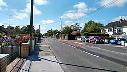
Rolestown, or Rowlestown, is a small village six miles (10 km) north-west of Swords along the R125 in Fingal, Ireland. It lies about halfway between Swords and Ashbourne. It is located around two parallel roads intersected by a road that crosses the Broadmeadow River by an old cut stone bridge. Rolestown is also a parish in the Fingal North deanery of the Roman Catholic Archdiocese of Dublin.

Many companies operate public transport services in Dublin, most of which are state-owned or semi-state-owned.
Brighton Hill is a district of Basingstoke, England, that was formed around 1970 as part of the Town Centre Development Plan. The area is bounded to the west by the newer housing estate of Hatch Warren and by the A30. To the east of Brighton Hill, the Viables Industrial Estate and Cranbourne area. The area to the east is a lot older than Brighton Hill itself. The M3 motorway runs in a straight line to the south of the area, directly next to the southern ebb of Brighton Hill, which sometimes is referred to as Old Hatchwarren.

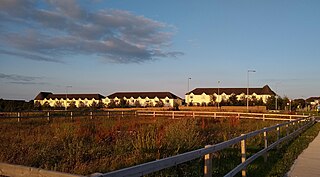
Clongriffin is a community in northern Donaghmede, on the northern fringe of Dublin, Ireland. The settlement was based on a master plan vision from major developer Gannon Homes, with significant investment in transport infrastructure and also community and recreational amenities. Development slowed during the downturn in the economy, although activity renewed in recent years, with planning permission secured for a hotel and range of additional homes including a 16-storey apartment block with residential lounges and roof gardens..
Holywell is a neighbourhood near Swords, Dublin, Ireland. Developed and marketed in phases and under various names, Feltrim Hall, Gorse Hill, Abbey Stone, Holywell and The Meadows, all the street names in the community include the common name Holywell e.g. 'Holywell Drive'. It is the eastern part of the census town of Kinsealy–Drinan, separated from the western part by the M1 motorway.

Applewood is a neighbourhood in the suburban town of Swords, near Dublin, Ireland. It was built around the year 2002 by property developer Gerry Gannon. It has been designed "village-style" with shops in the centre and housing estates surrounding this. In 2006, it won the Best Urban Village award at the National Tidy Towns competition.
Knocksedan is a rural townland near the town of Swords in Ireland. It is situated along the Naul Road (R108) to the west of Swords on either side of the Ward River. It was the site of the muster of the Fingal Volunteers on Easter Monday 1916.

Brackenstown is a neighbourhood in the north Dublin suburb of Swords in Ireland. It developed in west Swords on the north side of the Ward River. It developed along the Brackenstown Road, which runs from Swords to the townland of Knocksedan. It has shops, including a supermarket and a pub, and is adjacent to the Ward River Valley Park. Brackenstown is also a parish in the Fingal North deanery of the Roman Catholic Archdiocese of Dublin.
Bus Éireann Route 101 is a bus route in Ireland, that runs from Talbot Street, in Dublin city centre, to the Bus Station in the town of Drogheda, via Swords, Balbriggan and Julianstown. It is operated by Bus Éireann and is the main bus route connecting Drogheda to Dublin. Routes 101X and 100X are peak time express services using the Dublin Port Tunnel and M1 motorway and route 101N a weekend Nightrider service.