Applewood, Swords

Last updated

Applewood
Coill na nÚll [1]
Suburban area
ApplewoodMainStreet.jpg
Main Street
Dublin map.png
Red pog.svg
Applewood
Location in Dublin area
Coordinates: 53°28′16″N6°13′57″W / 53.4711°N 6.2325°W / 53.4711; -6.2325 Coordinates: 53°28′16″N6°13′57″W / 53.4711°N 6.2325°W / 53.4711; -6.2325
Country Ireland
Province Leinster
Region Dublin
County Fingal
Town Swords
Built from2002
Government
   Dáil Éireann Dublin Fingal
   EU Parliament Dublin
Time zone UTC+0 (WET)
  Summer (DST) UTC-1 (IST (WEST))
Area code +353 (0)1
Irish Grid Reference O 174 483

Applewood is a neighbourhood in the suburban town of Swords, near Dublin, Ireland. It was built around the year 2002 by property developer Gerry Gannon. It has been designed "village-style" with shops in the centre and housing estates surrounding this. In 2006, it won the Best Urban Village award at the National Tidy Towns competition. [2]

Contents

Layout

Applewood is located north-west of the centre of Swords. The Glen Ellan Distributor Road is the main road providing access to the area. It starts at the Balheary Road and runs west as far as the Applewood Roundabout, then turns south to end at the Rathbeale Road at Outlands Cross. The Rathbeale Road provides access into the centre of Swords and the Balheary Road provides access onto the R132 dual carriageway. The South Bank, Glen Ellan and Sandford Wood estates are on the south side of the Glen Ellan Road while Applewood Main Street, and the Applewood, Braeburn, Bramley and Thornleigh Estates are on the north side of the road. The Jugback estate is on both sides of the road.

An extension of the Glen Ellan Road runs west from the Applewood Roundabout into the Oldtown "future development lands" and provides access into the Brides Glen and Bunbury Gate estates and to the Swords Educate Together National School, Gaelscoil Bhrian Bóroimhe and Applewood Community Centre. Another unnamed distributor road runs north from the Applewood roundabout to the Broadmeadow Linear Park and provides access to the Ashton and Castleview Estates. [3]

Public transport

Applewood (Glen Ellan Road) is served by Dublin Bus Routes 41c, 41x & 43 and the Swords Express service. [4]

Dublin Bus route 41c operates approximately every 20 minutes from Swords Manor to Dublin City Centre (Lwr Abbey Street) through Applewood, Swords Village, River Valley, Santry and Drumcondra. [5] At peak times route 41x operates a service to UCD Belfield via Dublin City Centre [6] and route 43 operates a service to Dublin City Centre via Kinsealy and the Malahide Road. [7]

The Swords Express service runs approximately every 30 minutes from Swords Manor to Dublin City Centre (Georges/Eden Quay) through Applewood, Swords Village and Holywell, then express via the M1 motorway and Port Tunnel. [8]

Parks

The Broadmeadow Linear Park is a small park north of Applewood along the Broadmeadow River. Fingal County Council plan to extend the park eastwards to Balheary Park and westwards into the proposed Swords Regional Park. [9]

Balheary Park is east of Applewood at the confluence of the Broadmeadow River and the Ward River. It surrounds Swords Business Campus on three sides and has some playing pitches which are used by St. Colmcille's GAA club. In mid-2006, Fingal County Council built a skatepark and adjoining basketball courts/football court in Balheary Park.[ citation needed ]

The Fingal Council Local Area Plan (2005-2011) proposed a new 65 hectares (160 acres) regional park for Swords. If developed as planned, it would be located north-east of Applewood, stretching from the Rathbeale Road to the Broadmeadow River. The park is proposed to be immediately west of Oldtown and adjoining and ultimately extending into the Broadmeadow River Valley Linear Park. The park is proposed to serve Swords and its hinterland, and comprise active recreational and passive activities, commensurate with the Council’s vision for the emerging city of Swords. [10] [ needs update ]

Education

There are three primary schools in the Applewood area:

Gaelscoil Bhrian Bóroimhe and Swords Educate Together National School share the same campus with Applewood Community Centre. The two 16 classroom schools and community centre campus opened in 2011. [14] The Thornleigh Educate Together 18 classroom school opened in 2012. [15]

Related Research Articles

<span class="mw-page-title-main">Swords, Dublin</span> County town of Fingal (in the traditional County Dublin), Ireland

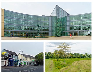
Swords, the county town of Fingal, is a large suburban town on the east coast of Ireland, situated ten kilometres north of Dublin city centre. The town was reputedly founded c. AD 560. Located on the Ward River, Swords features Swords Castle, a restored medieval castle, a holy well from which it takes its name, a round tower and a Norman tower. Facilities in the area include the Pavilions shopping centre, one of the largest in the Dublin region, a range of civic offices, some light industries, the main storage facility and archive of the National Museum of Ireland and several parks. Dublin Airport is located nearby.

<span class="mw-page-title-main">Blanchardstown</span> Large western suburb of Dublin, Ireland

Blanchardstown is a large outer suburb of Dublin in the modern county of Fingal, Ireland. Located ten kilometres (6 mi) northwest of Dublin city centre, it has developed since the 1960s from a small village to a point where Greater Blanchardstown is the largest urban area in Fingal.

<span class="mw-page-title-main">Donabate</span> Small coastal town in Fingal, Ireland

Donabate is a small coastal town in Fingal, Ireland, about 20 kilometres north-northeast of Dublin. The town is on a peninsula on Ireland's east coast, between the Rogerstown Estuary to the north and Broadmeadow Estuary to the south. Donabate is a civil parish in the ancient barony of Nethercross.

<span class="mw-page-title-main">Knocklyon</span> Suburb of Dublin, Ireland

Knocklyon is a suburb of Dublin in county of South Dublin, within the old County Dublin, Ireland. Unlike many Dublin suburbs, Knocklyon was not developed around a village; rather it largely comprises modern housing built between the village of Templeogue and the former hamlet, now a suburb in its own right, of Firhouse. A number of old cottages and farmhouses along Knocklyon Road attest to the area's rural past.

<span class="mw-page-title-main">Malahide</span> Suburban settlement north of Dublin, Ireland

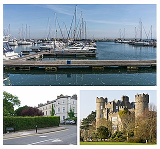
Malahide is an affluent coastal settlement in Fingal, County Dublin, Ireland, situated 14 kilometres (9 mi) north of Dublin city. It has a village centre surrounded by suburban housing estates, with a population of over 17,000.

<span class="mw-page-title-main">Lucan, Dublin</span> Town in County Dublin, Ireland

Lucan is a town in Ireland, located 12 km west of Dublin city centre on the River Liffey. It is near the Strawberry Beds and Lucan Weir, and at the confluence of the River Griffeen. It is mostly under the jurisdiction of South Dublin County Council with the exception of the North Lucan areas of Laraghcon, Coldblow and Saint Catherine's Park which are in the jurisdiction of Fingal County Council. Road access to Lucan is from the N4, and the M50 motorway at Junction 7. It is widely regarded to be the Montreal of Dublin.

<span class="mw-page-title-main">Clonsilla</span> Western suburb of Dublin, Ireland

Clonsilla is an outer suburb of Dublin in Fingal, Ireland.

<span class="mw-page-title-main">Coolmine</span> Suburb of Dublin, Ireland

Coolmine is a primarily residential suburb of Dublin, Ireland, in the jurisdiction of Fingal. It is also a townland in the civil parish of Clonsilla.

<span class="mw-page-title-main">Santry</span> Suburb of Dublin, Ireland

Santry is a suburb on the northside of Dublin, Ireland, bordering Coolock, Glasnevin, Kilmore and Ballymun. It straddles the boundary of Dublin City Council and Fingal County Council jurisdictions.

Kilbarrack is a residential suburb of Dublin, Ireland, running inwards from the coast, about 8 km (5.0 mi) from the city's centre. It is also a civil parish in the ancient barony of Coolock. Modern-day Kilbarrack is within the jurisdiction of Dublin City Council, with part of its old lands now in Donaghmede, and part in Bayside under Fingal County Council jurisdiction.

<span class="mw-page-title-main">Tyrrelstown</span> Townland and outer suburb of Dublin, Ireland

Tyrrelstown is a townland in the civil parish of Mulhuddart, located 13 km northwest of the city of Dublin in Ireland and often considered as part of the greater Blanchardstown area. It is the site of a planned suburban development from the early 2000s. The local authority for the area, which forms part of the Dublin 15 postal district, is Fingal County Council.

Oldtown is a population centre and townland in the civil parish of Clonmethan in Fingal, Ireland. The R122 road runs through the village linking Naul to St Margaret's and Dublin Airport.

<span class="mw-page-title-main">Rolestown</span> Village in Fingal, North County Dublin

Rolestown, or Rowlestown, is a small village six miles (10 km) north-west of Swords along the R125 in Fingal, Ireland. It lies about halfway between Swords and Ashbourne. It is located around two parallel roads intersected by a road that crosses the Broadmeadow River by an old cut stone bridge. Rolestown is also a parish in the Fingal North deanery of the Roman Catholic Archdiocese of Dublin.

<span class="mw-page-title-main">Public transport operators in Dublin</span>

Many companies operate public transport services in Dublin, most of which are state-owned or semi-state-owned.

<span class="mw-page-title-main">Holywell, Swords</span> Neighbourhood in Dublin, Leinster, Ireland

Holywell is a neighbourhood near Swords, Dublin, Ireland. Developed and marketed in phases and under various names, Feltrim Hall, Gorse Hill, Abbey Stone, Holywell and The Meadows, all the street names in the community include the common name Holywell e.g. 'Holywell Drive'. It is the eastern part of the census town of Kinsealy–Drinan, separated from the western part by the M1 motorway.

<span class="mw-page-title-main">Demographics of Swords</span> I dont know

Swords has developed into the largest town in Ireland. The town's population boom began in the 1970s with the construction of the sprawling Rivervalley Estate, Ireland's largest private housing development, ahead of Kilnamanagh Estate in Tallaght North, and continued during the 1990s and 2000s, with many new residents moving to the area due to its proximity to their work at Dublin Airport. Swords is accessed by the R132 and the M1 motorway.

Knocksedan is a rural townland near the town of Swords in Ireland. It is situated along the Naul Road (R108) to the west of Swords on either side of the Ward River. It was the site of the muster of the Fingal Volunteers on Easter Monday 1916.

<span class="mw-page-title-main">Rathbeale, Swords</span> Neighbourhood of Swords in Dublin, Leinster, Ireland

Rathbeale is a neighbourhood in the town of Swords in Ireland. It developed in west Swords along the Rathbeale Road (R125), which runs from Swords to the townland of Rathbeal. It has been designed around the Rathbeale Road, which has shops, including two supermarkets, with housing estates on either side of the road.

<span class="mw-page-title-main">Brackenstown, Swords</span> Neighbourhood of Swords in Ireland

Brackenstown is a neighbourhood in the north Dublin suburb of Swords in Ireland. It developed in west Swords on the north side of the Ward River. It developed along the Brackenstown Road, which runs from Swords to the townland of Knocksedan. It has shops, including a supermarket and a pub, and is adjacent to the Ward River Valley Park. Brackenstown is also a parish in the Fingal North deanery of the Roman Catholic Archdiocese of Dublin.

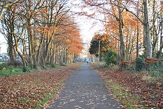
The Ward River, sometimes historically the Swords River, is a watercourse of County Meath and northern County Dublin. About 18 kilometres (11 mi) long; it runs through the town of Swords and then flows into the Broadmeadow River. The Ward is a salmonid river, with several species of fish, including brown trout. It has several small tributaries. The river is in the jurisdictions of Meath and Fingal County Councils, as well as within the oversight of the Environmental Protection Agency.

References

  1. Placenames Database of Ireland
  2. Tidy Towns Results 2006 Archived 2011-10-06 at the Wayback Machine page 15
  3. Applewood Map Archived 2012-08-29 at the Wayback Machine Ordnance Survey Ireland
  4. Transport for Ireland Public Transport Information
  5. Dublin Bus 41c Timetable
  6. Dublic Bus 41x Timetable
  7. Dublin Bus 43 Timetable
  8. Swords Express Timetable Archived 2012-06-15 at the Wayback Machine
  9. Broadmeadow Linear Park (Section 3.1.2)
  10. Swords Regional Park (Section 3.1.3)
  11. Gaelscoil Bhrian Bóroimhe
  12. Swords Educate Together National School
  13. "Thornleigh Educate Together National School". Archived from the original on 13 July 2012. Retrieved 10 September 2012.
  14. Oldtown School Campus Fingal Independent
  15. Thornleigh Educate Together Campus Fingal Independent