Clonliffe

Last updated

Clonliffe
Cluain Life
Inner city neighbourhood
Jones's Road, Clonliffe.jpg
Croke Park seen behind Victorian townhouses on Jones's Road, Clonliffe
Country Ireland
Province Leinster
County Dublin
Local authority Dublin City Council
Time zone UTC+0 (WET)
  Summer (DST) UTC-1 (IST (WEST))

Clonliffe (Irish : Cluain Life) is an area on the Northside of Dublin, Ireland, between Ballybough and Drumcondra in the Dublin 3 postal district.

Contents

Location

Clonliffe Road, previously known as Fortick's Lane, [1] is a wide thoroughfare that forms the central artery of the area. It is nearly a mile in length. [ citation needed ] Near the area's border with Drumcondra there is an entrance to Holy Cross College, and to the grounds of the residence of the Archbishop of Dublin. The main access to Croke Park GAA sports ground is from Jones Road, the principal turn-off on the south side of Clonliffe Road.

The historical area of Clonliffe was bounded by the River Tolka, down to the North Circular Road (possibly as far South as Aldborough House). [2]

History

Clonliffe as a named townland is mentioned in 1192, and the name is thought to mean "herb meadow" [3] or from "the plain of the Liffey" in reference to the River Liffey. [2] Clonliffe Road was originally known as Fortick's Lane, named for the previous owner of Clonliffe House, Tristram Fortick, [1] a saddle-maker who began leasing the property from John Graham (an Alderman from Drogheda) on a 94-year lease in March 1710. [4] Clonliffe House, also known as the Red House, is the earliest extant building in the area. Frederick Jones moved into the House and renamed the house and the road Clonliffe. The house was described in a poem by Thomas Caulfield Irwin: [2]

"There was a long, old road anear the town,

Skirted with trees:

One end joined a great highway; one led down

To open shores and seas.

There was no house on it save only one

Built years ago:

Dark foliage thickly blinded from the sun

Its casements low" [2]

At the corner of Clonliffe Road and Ballybough Road, there is an area which was historically used as a burial place for those who died by suicide. Criminals were also buried at this plot, and historian Eamonn Mac Thomáis states that the bodies of the highwayman, Larry Clinch, and his gang were displayed there after their execution. [5]

Clonliffe College, Clonliffe Clonliffe College 2.jpg
Clonliffe College, Clonliffe

In the mid-19th century, it was proposed that a university be located at Clonliffe. [6] In 1854, Holy Cross College (also known as Clonliffe College) was founded as the Dublin diocesan seminary for Dublin by Cardinal Paul Cullen (1803-1878). [7] The grounds of Clonliffe College form a large portion of the area today. The college is adjacent to the residence of the Archbishop of Dublin, which is located just North of Croke Park Stadium. [8]

Clonliffe Harriers is an athletics club based in Morton Stadium. [9]

Under the Drumcondra, Clonliffe, and Glasnevin Township Act 1878, it became part of the township of Drumcondra, Clonliffe and Glasnevin, within County Dublin. The area was absorbed into the city of Dublin in 1900. [10] [11]

Donnelly's Orchard

Housing built over the Donnelly Orchard area, Drumcondra, November 2022 Housing in Donnelly Orchard area today.png
Housing built over the Donnelly Orchard area, Drumcondra, November 2022

Donnelly's Orchard was a small housing scheme that Dublin Corporation undertook in 1923. Their intention was for this development to be finished in time to qualify for the Million Pound Grant. This area was a 12-acre plot on the banks of the River Tolka, previously used for allotments. Trustees seemed to be happy for this space to be used for housing, when the use of this space for allotments had ceased. Dublin Corporation's own housing department was too busy to undertake this project at this time, so the Corporation asked Messrs McDonnell and Dixon to undertake the task. The houses planned to be built were cottages, containing a parlour, living room, three bedrooms, a scullery and indoor sanitary facilities. Although, not everyone in the council agreed and in the meeting in April 1923 there was a proposal for smaller houses to be built so the people associated with the Corporation would be able to afford the rent. In 1933, the development was built to the size it stands today. 10 four-roomed cottages and 138 three-roomed cottages were built. During the same time, baths and hot water systems were installed in the previous housing developments in the area. The 1938 Ordnance Survey Plan displays the completed scheme, which includes the same design elements that are present in Drumcondra today; such as cul-de-sacs and short terraces with substantial garden space front and rear of the house. [12]

See also

Related Research Articles

<span class="mw-page-title-main">Glasnevin</span> Northern suburb of Dublin, Ireland

Glasnevin is a neighbourhood of Dublin, Ireland, situated on the River Tolka. While primarily residential, Glasnevin is also home to the National Botanic Gardens, Glasnevin Cemetery, the National Meteorological Office, and a range of other state bodies, and Dublin City University has its main campus and other facilities in and near the area. Glasnevin is also a civil parish in the ancient barony of Coolock.

<span class="mw-page-title-main">Northside, Dublin</span> Informal division of Dublin, Ireland

The Northside is the part of Dublin city that lies to the north of the River Liffey. It is an informal but commonly used term. While it is sometimes regarded as less wealthy than the city's Southside, the Northside was originally the home of the city's upper classes and the more privileged of the two. Today, some of the wealthiest areas in Ireland lie north of the river, such as Malahide, Howth, Clontarf, and Castleknock.

<span class="mw-page-title-main">Dorset Street, Dublin</span> Street in Dublin, Ireland

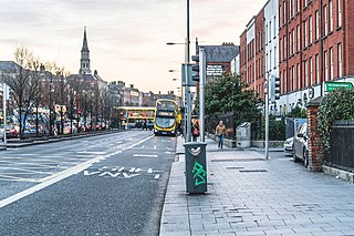
Dorset Street is an important thoroughfare on the northside of Dublin, Ireland, and was originally part of the Slighe Midh-Luchra, Dublin's ancient road to the north that begins where the original bridging point at Church Street is today. Subsequently, yet prior to the street being given its current name in the 18th century, the road was known as Drumcondra Lane and was shown on maps as such. It is divided into Dorset Street Lower and Dorset Street Upper.

<span class="mw-page-title-main">Drumcondra, Dublin</span> Inner suburb in Dublin, Leinster, Ireland

Drumcondra is a residential area and inner suburb on the Northside of Dublin, Ireland. It is administered by Dublin City Council. The River Tolka and the Royal Canal flow through the area.

<span class="mw-page-title-main">Fairview, Dublin</span> Northern suburb of Dublin, Ireland

Fairview is an inner coastal suburb of Dublin in Ireland, in the jurisdiction of Dublin City Council and in the city's D03 postal district. Part of the area forms Fairview Park, a recreational amenity laid out on land reclaimed from the sea.

<span class="mw-page-title-main">Tolka Park</span> Football stadium in Dublin, Ireland

Tolka Park is an Irish football ground located in the north Dublin suburb of Drumcondra, on the northern banks of the River Tolka. It is currently the home ground of League of Ireland club Shelbourne. The stadium formerly held 9,680 people, but this has been scaled down in recent times due to health and safety regulations in the venue, mainly concerning the 'New' and Ballybough stands. Tolka Park has hosted national cup finals along with international matches, Champions League qualifiers, UEFA Cup, UEFA Cup Winners' Cup ties and was a venue for the 1994 UEFA European Under-16 Championship and 2000 Rugby League World Cup.

<span class="mw-page-title-main">Santry</span> Suburb of Dublin, Ireland

Santry is a suburb on the northside of Dublin, Ireland, bordering Coolock, Glasnevin, Kilmore and Ballymun. It straddles the boundary of Dublin City Council and Fingal County Council jurisdictions.

<span class="mw-page-title-main">Ballybough</span> Northern inner city district of Dublin, Ireland

Ballybough is an inner city district of northeast Dublin city, Ireland. Adjacent areas include the North Strand and Clonliffe.

<span class="mw-page-title-main">River Tolka</span> River of Counties Meath and Dublin, Ireland

The River Tolka, also once spelled Tolga, is one of Dublin's three main rivers, flowing from County Meath to Fingal within the old County Dublin, and through the north of Dublin city, Ireland. By flow of water, the Tolka is the second largest river in Dublin, following the Liffey, but runs more slowly than the Dodder.

<span class="mw-page-title-main">Drumcondra railway station</span>

Drumcondra is a railway station on the Dublin Connolly to Longford and Grand Canal Dock to Newbridge commuter services. Almost all Sligo and Longford to Dublin services stop at Drumcondra.

<span class="mw-page-title-main">Marino, Dublin</span> Inner northern suburb of Dublin, Ireland

Marino is an inner suburb on the Northside of Dublin, Ireland. It was built, in a planned form, on former grounds of Marino House, in an area between Drumcondra, Donnycarney, Clontarf, and what became Fairview. The initial development featured around 1,300 concrete-built houses.

Donnycarney is a Northside suburb in the city of Dublin, Ireland, in the jurisdiction of Dublin City Council. It is mostly residential, around 5 kilometres (3.1 mi) from the centre of Dublin. Dublin GAA's home stadium, Parnell Park, is located here.

<span class="mw-page-title-main">Holy Cross College (Dublin)</span>

Holy Cross College, located in Clonliffe Road, Drumcondra was founded in 1854 as the Catholic diocesan seminary for Dublin by Cardinal Paul Cullen.

Clonturk is an area on the Northside of Dublin, in Ireland. It is located in the south of the suburb of Drumcondra, just north of the River Tolka, but previously, Clonturk had been an alternative name for Drumcondra and the wider area. Clonturk lies within the Dublin 9 postal district. The name Clonturk translates from the Irish as "Pasture of the boars". There is some evidence that the name originally was Ceann Torc or the "Headland of the boars", but had changed to Clonturk by the middle of the 16th century, perhaps under the influence of the more famous neighbouring placename Clontarf.

Drumcondra, Clonliffe and Glasnevin is a former second-tier local government area within County Dublin. It was created as a township in 1878. In 1899, it briefly became an urban district, before being abolished in 1900, with its area absorbed into the city of Dublin.

<span class="mw-page-title-main">Griffith Park, Dublin</span> Public park in Dublin, Ireland

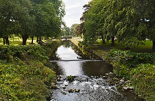
Griffith Park is a 7.5-hectare (19-acre) park located on the banks of the River Tolka in Dublin city between Glasnevin and Drumcondra. The park is a short distance downstream of Ireland's National Botanic Gardens, and upriver of Our Lady's Park, and has been noted by Discover Ireland as "one of the premier north city parks". The park closes at different times of the year, dependent on the hours of dusk.

<span class="mw-page-title-main">Our Lady's Park, Drumcondra</span> Public park in Dublin, Ireland

Our Lady's Park is a small 0.37-hectare (0.91-acre) boomerang-shaped park located on the banks of the River Tolka in Dublin city next to Frank Flood Bridge in Drumcondra. The park is notable for its statue of the Virgin Mary, presumably erected in 1954 for the Marian Year which had been declared by Pope John XXIII.

The Drumcondra ambush was an attempted ambush carried out the Irish Republican Army (IRA) in Drumcondra, a suburb in northern Dublin, during the Irish War of Independence. On 21 January 1921, an IRA active service unit (ASU) initially set up an ambush near the Royal Canal in preparation for a British lorry which was travelling through the area. When the lorry failed to arrive, Frank Flood, the unit's commander, relocated his men up to a new position along the Tolka river. However, the IRA unit was spotted as they were setting up their new positions and a force of Auxiliaries was sent out, which resulted in 1 volunteer being killed and 5 others being arrested as they were attempting to escape.

References

  1. 1 2 Hopkins, Frank (5 November 2009). "Big Wind Too Great A Trial For 'Big Tree'". Irish Independent. Retrieved 16 November 2022.
  2. 1 2 3 4 Cosgrave, Dillon (1904). "Clonliffe". The Journal of the Royal Society of Antiquaries of Ireland. 34 (4): 361–364. ISSN   0035-9106. JSTOR   25507393.
  3. M'Cready, C. T. (1987). Dublin street names dated and explained. Blackrock, Co. Dublin: Carraig. p. 23. ISBN   1-85068-005-1. OCLC   263974843.
  4. Registry of Deeds, Dublin. Memorial: 6-172-1707. "A Memoriall of Indenture of Lease bearing date the Second day of December One Thousand Seven Hundred and Ten made and perfected between John Graham of the Towne of Drogheda, Alderman of the one part and Tristram Fortick of the City of Dublin, Sadler of the other part... All that and those the Great House of the Grange of Clonliffe with all the out houses, walls, coveniencys and appurtenances thereunto belonging or in anywise appertaining And also all that piece or parcell of land thereunto next adjoyning comonly known by the name of part of the Grange Land containing from the outside of the mearing gripe of the said land all round to the river nine acres be the same more or less... fronting the New Avenew intended to be made by the said Fortick before the said Great House... To hold to him the said Tristram Fortick, his executors, administrators and assignes from the Twenty Fifth of March last past for Ninety Four yeares at and under the yearly rent of Thirty Six pounds sterling..."
  5. "Ballybough and the mysterious 'Suicide Plot'". Come Here To Me!. 19 March 2018. Retrieved 16 November 2022.
  6. "1864 – Proposed University of Ireland, Clonliffe, Dublin". Archiseek - Irish Architecture. 5 February 2010. Retrieved 31 January 2022.
  7. Cardinal Paul Cullen, Multitext Irish History project Archived 12 October 2008 at the Wayback Machine www.ucc.ie website
  8. "HOLY CROSS COLLEGE". DUBLIN STREET IMAGES. Retrieved 28 November 2022.
  9. "Official site of Clonliffe Harriers" . Retrieved 28 November 2022.
  10. McManus, Ruth (2002). Dublin, 1910–1940: shaping the city & suburbs. Four Courts. p. 313. ISBN   9781851827121.
  11. Dublin Corporation Act 1900, [63 & 64 Vict., Ch. cclxiv]
  12. Brady, Joseph (2021). Building healthy homes: Dublin Corporation's first housing schemes 1880-1925. Ruth McManus, Dublin. City Council. Dublin. pp. 233–235. ISBN   978-0-9500512-6-0. OCLC   1224246136.{{cite book}}: CS1 maint: location missing publisher (link)