Ballsbridge is an affluent neighbourhood of the city of Dublin, the capital of Ireland. The area is largely north and west of a three-arch stone bridge across the River Dodder, on the south side of the city. The sign on the bridge still proclaims it as "Ball's Bridge", in recognition of the fact that the original bridge on that location was built and owned by the Ball family, a well-known Dublin merchant family in the 1500s and the 1600s. The current bridge was built in 1791.

The N11 road is a national primary road in Ireland, running for 129 km (80 mi) along the east side of Ireland from Dublin to Wexford. It passes close to Bray, Greystones, Wicklow, Arklow, Gorey, and Enniscorthy. Beyond Wexford, the route continues to Rosslare as the N25. The road forms part of European route E01. As of July 2019 the N11/M11 is of dual carriageway or motorway standard from Dublin as far as Oilgate in County Wexford.

Merrion Square is a Georgian garden square on the southside of Dublin city centre.

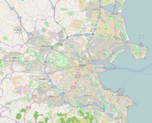
Dublin 4, also rendered as D4 and D04, is a historic postal district of Dublin, Ireland including Baggot Street Upper, the southernmost fringes of the Dublin Docklands, and the suburbs of Ballsbridge, Donnybrook, Irishtown, Merrion, Ringsend and Sandymount, on the Southside of Dublin. Most of the area was known as Pembroke Township until 1930 when it was absorbed by the City and County Borough of Dublin.

Ailesbury Road, Dublin 4, Ireland, is an affluent tree-lined avenue linking Sydney Parade Station on Sydney Parade Avenue and the Church of the Sacred Heart, Donnybrook. Many embassies and diplomatic residences have historically been located on the road, including the striking residence of the French Ambassador, the embassy of the People's Republic of China, and the Japanese embassy

Sandymount is an affluent coastal suburb in the Dublin 4 district on the Southside of Dublin in Ireland.
Mount Merrion is a suburb of Dublin, Ireland. It is roughly 7 kilometres (5 mi) south of Dublin city centre and is situated on and around the hill of the same name.

Booterstown is a coastal suburb of the city of Dublin in Ireland. It is also a townland and civil parish in the modern county of Dún Laoghaire–Rathdown. It is situated about 7 km (4.3 mi) south of Dublin city centre.
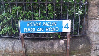
Raglan Road is a road running between Pembroke Road and Clyde Road in Ballsbridge, Dublin 4, Ireland. It is the setting of Patrick Kavanagh's poem "On Raglan Road".
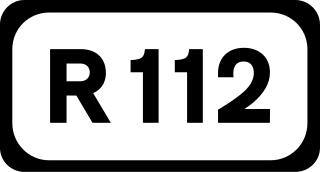
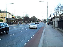
The R112 road is a regional road in south Dublin, Ireland. It begins at the junction with the R148 road at Chapelizod and arcs southeastwards, then eastwards across the middle of south Dublin, ending at the Mount Merrion junction of the R138. The road is a single carriageway, with cycle lanes on some stretches. Improvements to the road have been made over the last 10 years, the most significant being at Dundrum Cross where the road was widened to make room for the new Luas bridge and Dundrum bypass.
The R824 road is a regional road in south Dublin, Ireland. The road starts somewhere between Sandford and Clonskeagh, passes through Donnybrook and finishes at the junction with the Merrion Road and Ailesbury Road close by to Sydney Parade.

The R118 road is a regional road in south Dublin and Dún Laoghaire–Rathdown, Ireland. It links Kildare Street to Cherrywood.
The R131 road is a regional road in Dublin, Ireland.

The R815 road is a regional road in Dublin, Ireland.
Merrion is a townland and suburban area located about 4 km south east of Dublin City. The townland has an area of approximately 0.8 square kilometres (0.3 sq mi).

The Embassy of the United States of America in Dublin is the diplomatic mission of the United States of America to the Republic of Ireland.

The R138 road is a regional road in Ireland. It commences at the south end of O'Connell Bridge in Dublin city centre. It proceeds along D'Olier Street, College Street.

The Embassy of the United Kingdom in Dublin is the chief diplomatic mission of the United Kingdom of Great Britain and Northern Ireland in Ireland. The Embassy is located on Merrion Road in the Ballsbridge area of the city. The current British Ambassador to Ireland is Paul Johnston.

The Embassy of France in Ireland is the diplomatic mission of the French Republic in Ireland. It is located in Dublin.
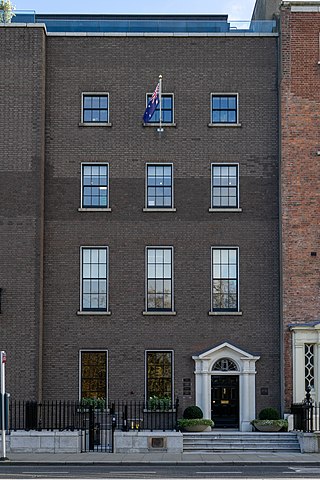
The Embassy of Australia in Ireland is the diplomatic mission of the Commonwealth of Australia in Ireland. The embassy is located in the capital city of Ireland, Dublin.