
Dublin is the capital of Ireland. On a bay at the mouth of the River Liffey, it is in the province of Leinster, bordered on the south by the Dublin Mountains, a part of the Wicklow Mountains range. At the 2022 census, the city council area had a population of 592,713, while Dublin City and its suburbs had a population of 1,263,219, and County Dublin had a population of 1,501,500, making it the largest city by size on the island of Ireland.

The River Liffey is a river in eastern Ireland that ultimately flows through the centre of Dublin to its mouth within Dublin Bay. Its major tributaries include the River Dodder, the River Poddle and the River Camac. The river supplies much of Dublin's water and supports a range of recreational activities.

Temple Bar is an area on the south bank of the River Liffey in central Dublin, Ireland. The area is bounded by the Liffey to the north, Dame Street to the south, Westmoreland Street to the east and Fishamble Street to the west. It is promoted as Dublin's 'cultural quarter' and, as a centre of Dublin's city centre's nightlife, is a tourist destination. Temple Bar is in the Dublin 2 postal district.

Tara Street is a railway station in central Dublin, Ireland. It is adjacent to the Loopline Bridge on George's Quay.

Canada Water is an area of the Docklands in south-east London. It is named after a freshwater lake and wildlife refuge. Canada Water tube, Overground and bus station is immediately north of the lake, along with Canada Water Library which overhangs the lake and Deal Porter Square. Surrey Quays Shopping Centre is also adjacent, sitting immediately to the south. The surrounding area, which forms the town centre of Rotherhithe, is now increasingly known as Canada Water, after the transport interchange as much as the lake itself.

Dublin 1, also rendered as D1 and D01, is a postal district on the northside of Dublin, Ireland.

Broadstone is one of the three neighbourhoods that make up present-day Phibsboro in Dublin, Ireland. The most southerly of these, it begins just two kilometres north of Father Mathew Bridge at Ormond Quay. The area is triangular, bounded by Phibsborough Road and Constitution Hill to the West, North Circular Road to the north, and Dorset Street and Bolton Street to the south-east. The postal district for the area is Dublin 7.

Kent Station is an Iarnród Éireann railway station in Cork, Ireland. Originally opened in 1893, the station operates as a hub for Intercity services to Dublin and Tralee and commuter services to Mallow, Cobh and Midleton. In 2016, Kent Station was the fifth busiest station in the Republic of Ireland, as well as the busiest outside of Dublin.

North Wall is an area east of the inner north side of Dublin, along the River Liffey where it forms one of the Dublin quays.

Dublin Docklands is an area of the city of Dublin, Ireland, on both sides of the River Liffey, roughly from Talbot Memorial Bridge eastwards to the 3Arena. It mainly falls within the city's D01 and D02 postal districts but includes some of the urban fringes of the D04 district on its southernmost side.

Grand Canal Dock is a Southside area near the city centre of Dublin, Ireland. It is located on the border of eastern Dublin 2 and the westernmost part of Ringsend in Dublin 4, surrounding the Grand Canal Docks, an enclosed harbour where the Grand Canal comes to the River Liffey. The area has undergone significant redevelopment since 2000, as part of the Dublin Docklands area redevelopment project.

The Great South Wall, at the Port of Dublin, extends from the tip of the Poolbeg peninsula more than four kilometres out into Dublin Bay. It was the world's longest sea wall at the time of its construction and remains one of the longest in Europe. It faces the newer Bull Wall, and has one of four port lighthouses at its end.

Sir John Rogerson's Quay is a street and quay in Dublin on the south bank of the River Liffey between City Quay in the west and Britain Quay. Named for politician and property developer Sir John Rogerson (1648–1724), the quay was formerly part of Dublin Port. It has some of the few remaining campshire warehouses in Dublin.

Britain Quay is a street and quay in Dublin on the south bank of the River Liffey between Sir John Rogerson's Quay and the confluence of the River Liffey, River Dodder and Grand Canal.

The Dublin quays refers to the two roadways and quays that run along the north and south banks of the River Liffey in Dublin, Ireland. The stretches of the two continuous streets have several different names. However, all but two of the names share the same "quay" designation. The quays have played an important part in Dublin's history.

Grangegorman is an inner suburb on the northside of Dublin city, Ireland. The area is administered by Dublin City Council. It was best known for decades as the location of St Brendan's Hospital, which was the main psychiatric hospital serving the greater Dublin region. As of 2020, the area is the subject of a major redevelopment plan, running for more than a decade, under the aegis of the Grangegorman Development Agency, including the new Technological University Dublin campus.

The Rosie Hackett Bridge is a road and tram bridge in Dublin, Ireland, which opened on 20 May 2014. Spanning the River Liffey and joining Marlborough Street to Hawkins Street, it is used solely by public transport, taxis, cyclists and pedestrians. It is 26 metres wide and 48 metres long, and is a single span, smooth concrete structure, with the underside of the bridge designed to be as high above the water as possible so that river traffic is not impeded. It was built to carry the extended Luas Green line, and was budgeted at €15 million. It is named for trade unionist Rosie Hackett (1893–1976).
The Docklands Strategic Development Zone (SDZ) (known officially as the North Lotts and Grand Canal Dock SDZ Planning Scheme) is a controversial strategic planning area in Dublin, Ireland located east of the city centre on both sides of the River Liffey in the North Wall and Grand Canal Dock areas.
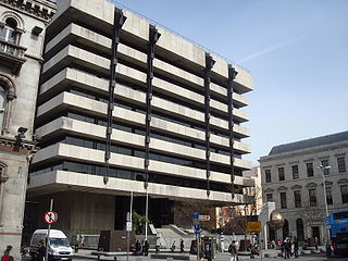
Central Plaza, also known as the Central Bank of Ireland Building for its former tenant, is an office building on Dame Street in Temple Bar, Dublin. It was the headquarters of the Central Bank of Ireland from 1979 to 2017.

