Conradh na Gaeilge is a social and cultural organisation which promotes the Irish language in Ireland and worldwide. The organisation was founded in 1893 with Douglas Hyde as its first president, when it emerged as the successor of several 19th century groups such as the Gaelic Union. The organisation was a spearhead of the Gaelic revival and of Gaeilgeoir activism.
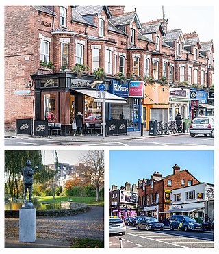
Ranelagh is an affluent residential area and urban village on the Southside of Dublin, Ireland in the postal district of Dublin 6.

Spencer Dock is a former wharf area, close to where the Royal Canal meets the River Liffey, in the North Wall area of Dublin, Ireland. As of the 21st century, the area has been redeveloped with occupants of the Spencer Dock development including the Convention Centre Dublin, PricewaterhouseCoopers' Irish headquarters, Credit Suisse and TMF Group. The Central Bank of Ireland and NTMA have offices in the nearby Dublin Landings development.

Broadstone is one of the three neighbourhoods that make up present-day Phibsboro in Dublin, Ireland. The most southerly of these, it begins just two kilometres north of Father Mathew Bridge at Ormond Quay. The area is triangular, bounded by Phibsborough Road and Constitution Hill to the West, North Circular Road to the north, and Dorset Street and Bolton Street to the south-east. The postal district for the area is Dublin 7.

The Green Line is one of the two lines of Dublin's Luas light rail system. The Green Line was formerly entirely in the south side of Dublin city. It mostly follows the route of the old Harcourt Street railway line, which was reserved for possible re-use when it closed in 1958. The Green Line allows for passengers to transfer at O’ Connell GPO and Marlborough to Luas Red Line services and also allows commuters to use Broombridge as an interchange station to reach outer suburbs such as Castleknock and Ongar as well as Iarnrod Éireann services.
Parnell Square is a Georgian square sited at the northern end of O'Connell Street in the city of Dublin, Ireland. It is in the city's D01 postal district.
Ulick Joseph Bourke was an Irish scholar and writer who founded the Gaelic Union, which later developed into the Gaelic League. Among his works were The College Irish Grammar and Pre-Christian Ireland.

The Harcourt Street Railway Line was a railway line that ran from Harcourt Street in Dublin through the southern suburbs to Bray. It was one of the Dublin and South Eastern Railway's two northern main lines, the other being the coastal line to Westland Row.

Dartry is a small suburb of Dublin, Ireland, often referred to as a corridor between Rathmines area and Milltown. Among the locations in Dartry are Dartry Road, Temple Road, Orwell Park and Palmerston Park.

Broadstone railway station was the Dublin terminus of the Midland Great Western Railway (MGWR), located in the Dublin suburb of Broadstone. The site also contained the MGWR railway works and a steam locomotive motive power depot. A Luas tram station opened at the front of the station in 2017.
Raidió Rí-Rá, founded in 2008, is an Irish language chart music radio station broadcasting on the Internet, and, for approximately one month a year, on FM radio. The station has offices on Harcourt Street in Dublin.

Harcourt Street railway station is a former railway terminus in Dublin. The station opened in 1859 and served as the terminus of the line from Dublin to Bray in County Wicklow. It closed in 1958 following the closure of the Harcourt Street line. Since 2004, there has been a Luas tram stop outside the front of the old station.
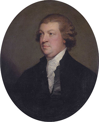
John Scott, 1st Earl of Clonmell PC (Ire) KC SL, known as The Lord Earlsfort between 1784 and 1789 and as The Viscount Clonmell between 1789 and 1793, was an Irish barrister and judge. Sometimes known as "Copperfaced Jack", he was Lord Chief Justice of the King's Bench for Ireland from 1784 to 1798.

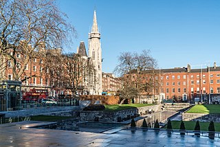
The Iveagh Gardens is a public park located between Clonmel Street and Upper Hatch Street, near the National Concert Hall in Dublin, Ireland. It is a national, as opposed to a municipal park, and designated as a National Historic Property. The gardens are almost completely surrounded by buildings making them less noticeable and a little hard to find, unlike other green spaces in Dublin.

Carrickmines is a stop on the Luas light rail tram system in Dún Laoghaire–Rathdown, County Dublin, Ireland, which serves the nearby village of Carrickmines. It opened in 2010 and was built on the site of a disused heavy rail station of the same name.

Sandyford is a stop on the Luas light rail tram system in Dún Laoghaire–Rathdown, south of Dublin, Ireland which serves the nearby suburb of Sandyford. It opened in 2004 as the southern terminus of the Green Line, which re-uses the alignment of the Harcourt Street railway line which closed in 1958. Sandyford Luas stop is located on the same site as a station on the old line called Stillorgan.

Beechwood is a stop on the Luas light rail tram system in Dublin, Ireland which serves the southern parts of Ranelagh and Rathmines. It opened in 2004 as a stop on the Green Line, which re-uses the alignment of the Harcourt Street railway line which closed in 1958. Beechwood Luas stop is located on the same site as a station on the old line called Rathmines and Ranelagh, although it is lower than the original station.

Milltown is a stop on the Luas light rail tram system in Dublin, Ireland which serves Milltown, Dublin and southern parts of Dartry, including Trinity Hall. It opened in 2004 as a stop on the Green Line, which re-uses the alignment of the Harcourt Street railway line which closed in 1958. Milltown Luas stop is located a few yards north of the site of the former rail station of the same name.

Dundrum is a stop on the Luas light rail tram system in Dublin, Ireland which serves the suburb of Dundrum. It opened in 2004 as a stop on the Green Line, which re-uses the alignment of the Harcourt Street railway line which closed in 1958. Dundrum Luas stop is built on the same site as a former heavy rail station of the same name.

