Shelbourne Road

Last updated • 8 min readFrom Wikipedia, The Free Encyclopedia

Shelbourne Road
Dublin map.png
Red pog.svg
Native nameBóthar Shíol Bhroin (Irish)
Former name(s)Artichoke Road, Beggar's Bush Road
Namesake William Petty, 2nd Earl of Shelburne
Length900 m (3,000 ft)
Width19 metres (62 ft)
Location Ballsbridge, Dublin, Ireland
Postal code D04
Coordinates 53°20′02″N6°13′55″W / 53.33401°N 6.231969°W / 53.33401; -6.231969
north end Merrion Road
south endBath Avenue, Haddington Road, Grand Canal Street Upper

Shelbourne Road (Irish : Bóthar Shíol Bhroin) [1] is a road in Ballsbridge, in the southeast part of Dublin, Ireland.

Contents

History

In John Rocque's map of 1756, today's Shelbourne Road and Upper Grand Canal Street, from which it extends, appear together as Beggars' Bush Road. Wilson's Plan of 1793 shows that Beggars' Bush Road has become known as Artichoke Road. Some sources [2] attribute this change of name to John Villiboise, a French Huguenot, who had obtained a 99-year lease on 1 rood of land from Richard 5th Viscount Fitzwilliam in 1736 [lower-alpha 1] and who planted artichokes on the land adjoining his house. This house, located in the vicinity of today's Holles Street, became known as Artichoke House and eventually the road became known as Artichoke Road. In William Duncan's map of 1821, the district known as Beggars' Bush is a rather ill-defined area that seems to coincide more or less with the area of land now occupied by Lansdowne Road's rugby stadium and the houses to its west. Later ordnance survey maps give the precise size and boundaries for Beggars Bush: it is an area of 116 acres, 2 roods and 21 perches bounded on the east by the Dodder from the bridge at Ballsbridge to the bridge at Ringsend; on the north by Ringsend Road from Ringsend bridge to South Lotts Road; on the south-west by South Lotts Road to Beggars Bush Road (Shelbourne Road); from Shelbourne Road to Lansdowne Road; the boundary then runs south-west on Lansdowne Road alongside Trinity College's botanical gardens and turns south on Pembroke Road to join the bridge at Ballsbridge. By 1827 the road was then commonly known by the names of both 'the Artichoke' and 'the Beggars Bush road'. [lower-alpha 2] Old street directories show that the name Artichoke Road was still in use in the 1860s, but that the numbering of houses ran in the opposite direction from that currently employed - for example, No. 2 Artichoke Road corresponds to No. 68 Shelbourne Road; No. 3 Artichoke Road corresponds to No. 66 Shelbourne Road, and so on.

The 1876 Ordnance Survey map refers to the road as Shelburne Road, a spelling that conforms to that of one of the titles of William Petty-Fitzmaurice, Marquess of Lansdowne, second Earl of Shelburne (family name Petty-FitzMaurice). Petty-Fitzmaurice, born in Dublin, was Prime Minister from 1782 to 1783. It is unclear how the spelling of today's Shelbourne Road acquired an o; Shelburne Falls in Massachusetts, also named in commemoration of William Petty-Fitzmaurice, has conserved the original spelling.

Location

Shelbourne Road runs south-east from Haddington Road and skirts the site of the former Beggars Bush Barracks. It crosses Lansdowne Road just west of the famous international rugby union and football grounds. From there, it runs southwest to Merrion Road which it meets at the River Dodder bridge.

Early maps seem to indicate that the route of today's Shelbourne Road was determined by the borders of the marshy Dodder estuary which, also fed by the Swan River (now culverted), and subject to tidal flooding, extended almost as far west as the site of the Beggars' Bush Barracks. Although reclamation of the area can be said to have started with the construction of Sir John Rogerson's Quay in 1713, it wasn't until William Vavasour took a 150-year lease at £80 per annum on an area of sixty acres of marshland between Beggars' Bush and Ringsend in 1792 that the area began to take on the appearance we recognise today. According to The Dublin Chronicle, ...This tract, which is every tide inundated by the tide and Dodder, the taker, it is said, intends immediately to reclaim by a complete double embankment of the Dodder, which, thus confined to a determined channel, will then form a handsome canal through it; a circumstance that will not only ornament an unsightly spot, but materially improve the salubrity of the air at Irishtown, Ring-send, &c”.. [3] Although further drainage works were undertaken in the 1830s to facilitate the construction of the Dublin and Kingstown Railway line, oyster and mussel shells frequently unearthed today during building and renovation works in houses along the road continue to provide reminders of the sea's recent presence.

James Joyce

In 1904, James Joyce rented the front upstairs room of No. 60 Shelbourne Road from a family called McKernan for a short period. [4] It was from this house that, on 16 June 1904, he set out for a rendezvous with Nora Barnacle, later to be his wife. He commemorated this date by choosing it as the day on which the action of his novel, Ulysses, takes place. The 16 June is now frequently referred to as 'Bloomsday'.

Farrington, the protagonist of Joyce's short story, Counterparts, alighted from a tram at Shelbourne Road and he steered his great body along in the shadows of the wall of the barracks as he made his way home, possibly to No. 60 Shelbourne Road.

Botanic Gardens

On the site now occupied by the Berkeley Court and Jurys hotels stood Trinity College's Botanic Gardens. In 2005, this seven-acre plot of land was purchased for €379 million, making this corner of Shelbourne Road perhaps the most expensive real estate in Europe. Plans to re-develop it have faltered.

Richard Turner

Richard Turner, best known for the Curvilinear Range in the Irish National Botanic Gardens, built his foundry, Hammersmith Ironworks, in 1834 on a six-acre site at the southern end of Shelbourne Road, immediately adjacent to Trinity College's Botanic Gardens. Many sections of the railings of Trinity College were cast in this foundry.

Turner built houses, known as Turner's Cottages, at the side of his ironworks for his employees. These two-storey buildings, which were opposite today's Ballsbridge Motors, comprised an outer terrace on Shelbourne Road with an arc of terraced houses directly behind that. At the time of the 1901 census, there were 24 buildings. By the time of the 1911 census, two more cottages had, apparently, been added. Collectively, they were nicknamed The Gut, for reasons that are not exactly clear but probably because the inner part of the estate was built in an arc, resembling a human gut. They survived until the early 1970s.

Swastika Laundry

The Swastika Laundry was a laundry founded in 1912, located on Shelbourne Road. They used electric vans, that were painted in red with a black swastika on a white background, [5] to collect and deliver laundry to customers.

The use of Shelbourne Road and Lansdowne Road copies the name street crossings in Kenmare, County Kerry, the origin perhaps being that the Cromwellian army physician Sir William Petty also "moonlighted" as a part-time ordinance surveyor/cartographer.[ citation needed ]

Shelbourne Football Club

Shelbourne Football Club, founded in 1895, was named as a result of the founders (who included James Rowan and 2 Wall brothers) tossed a coin under the Bath Avenue railway bridge to decide whether the name would be Bath FC or Shelbourne FC. The club originally played at St Marys Field close by, then at Shelbourne Park, and later moved to Ringsend("Pnuemonia Park") still terraced in the middle of a housing estate, followed by a short stay at Harolds Cross. Shelbourne FC now play on the northside of the city at Tolka Park.

Notes

  1. Registry of Deeds, Dublin. Memorial: 82-480-58668. Registered 04/06/1736. A Memorial of an Indenture of Lease bearing date the eighth day of May one thousand seven hundred and thirty six made between the Rt. Honble Richard Lord Viscount Fitz Williams of Merryon of the one part and John Villebois of the City of Dublin, Merchant, of the other part Whereby the said Richard Lord Viscount Fitz Williams did for the considerations therein mentioned Demise and set unto the said John Villebois all that and those the messuage or tenement with the appurtenances commonly called the Pot Yard together with the piece or plot of ground & garden behind the same containing in the whole one rood of ground be the same more or less [..] To hold to John Villebois for the term of ninety and nine years at the yearly rent of three pounds five shillings sterling to be paid quarterly and two sugar loaves weighing ten pounds or five shillings sterling in lieu thereof. Which said Indenture of Lease is witnessed by James Coningham of London, Merchant, and Henry Jones of the same city, Gent.
  2. Registry of Deeds, Dublin. Memorial: 827-290-556425 (Extract). Registered 31/08/1827. A Memorial of an Indented Deed of Release made the twenty eighth day of March in [..] the year one thousand eight hundred and twenty seven, between The Right Honorable George Augustus Earl of Pembroke and Montgomery of the one part and The Principal Officers of His Majesty’s Ordnance of the other part [..] assigns, All that and those that piece or parcel of Land at Beggars Bush being part of the Lands of Baggotrath alias Baggotsrath in the County of the City of Dublin containing Six acres two roods and Eighteen perches of Land Irish Plantation Measure bounded on the North by the Road called and known by the name of the Circular Road, on the South by other parts of said Lands of Baggotsrath in the possession of the said George Augustus Earl of Pembroke and Montgomery or his undertenants, on the East by the road leading to Balls Bridge commonly called and known by the name of the Artichoke or Beggars Bush road and on the West by other parts of said Lands of Baggotsrath...

Related Research Articles

<span class="mw-page-title-main">Ballsbridge</span> Southside suburb of Dublin city, Ireland

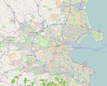
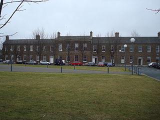
Ballsbridge is an affluent neighbourhood of the city of Dublin, the capital of Ireland. The area is largely situated north and west of a three-arch stone bridge across the River Dodder, on the south side of the city. The sign on the bridge still proclaims it as "Ball's Bridge", in recognition of the fact that the original bridge on that location was built and owned by the Ball family, a well-known Dublin merchant family in the 1500s and the 1600s. The current bridge was built in 1791.

<span class="mw-page-title-main">Henry Petty-Fitzmaurice, 5th Marquess of Lansdowne</span> Viceroy of India from 1888 to 1895

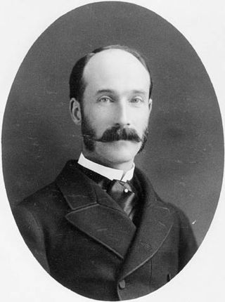
Henry Charles Keith Petty-Fitzmaurice, 5th Marquess of Lansdowne,, was a British statesman who served successively as Governor General of Canada, Viceroy of India, Secretary of State for War and Secretary of State for Foreign Affairs.

<span class="mw-page-title-main">William Petty, 2nd Earl of Shelburne</span> Prime Minister of Great Britain from 1782 to 1783

William Petty Fitzmaurice, 1st Marquess of Lansdowne,, was an Anglo-Irish Whig statesman who was the first home secretary in 1782 and then prime minister in 1782-83 during the final months of the American War of Independence. He succeeded in securing peace with America and this feat remains his most notable legacy.

<span class="mw-page-title-main">Henry Petty-Fitzmaurice, 3rd Marquess of Lansdowne</span> British politician (1780–1863)

Henry Petty-Fitzmaurice, 3rd Marquess of Lansdowne,, known as Lord Henry Petty from 1784 to 1809, was a British statesman. In a ministerial career spanning nearly half a century, he notably served as Home Secretary and Chancellor of the Exchequer and was three times Lord President of the Council.

<span class="mw-page-title-main">Bowood House</span> Country house in the United Kingdom

Bowood is a Grade I listed Georgian country house in Wiltshire, England, that has been owned for more than 250 years by the Fitzmaurice family. The house, with interiors by Robert Adam, stands in extensive grounds which include a garden designed by Lancelot "Capability" Brown. It is adjacent to the village of Derry Hill, halfway between Calne and Chippenham. The greater part of the house was demolished in 1956.

<span class="mw-page-title-main">Lansdowne Road</span> Former stadium in Dublin

Lansdowne Road Stadium was a stadium in Dublin owned by the Irish Rugby Football Union (IRFU) that was primarily used for rugby union and association football matches. The stadium was demolished in 2007 to make way for the Aviva Stadium on the same site, which opened in 2010.

<span class="mw-page-title-main">Lansdowne House</span> Building in London, England

Lansdowne House now 9 Fitzmaurice Place is the remaining part of an aristocratic English town house building to the south of Berkeley Square in central London, England. The initial name was for two decades Shelburne House, then its title matched its owning family's elevation to a higher peerage in 1784. In the mid to late 19th century, it was frequently let, as a whole, to families of very high wealth or income, such as Lord Rosebery and Hannah de Rothschild of Mentmore Towers from 1878 to 1890. Some of its 18th-century interiors, among the best in London, were taken elsewhere. It was at different times leased by three 19th century British prime ministers, and William Waldorf Astor, 1st Viscount Astor of Cliveden House, widely believed to be the richest man in America at the time of his tenancy (1891–1893) and also by Harry Gordon Selfridge in the 1920s. Landsdowne's heirs sold the property in 1929, two years after the death of the 5th Marquess, a prominent government frontbencher.

Lansdowne or Lansdown may refer to:

<span class="mw-page-title-main">Knocklyon</span> Suburb of Dublin, Ireland

Knocklyon is a suburb of the city of Dublin, located in South Dublin, Ireland. Unlike many Dublin suburbs, Knocklyon was not developed around a village; rather it largely consists of modern housing, with a number of old cottages and farmhouses along Knocklyon Road attesting to the area's rural past.

<span class="mw-page-title-main">Ringsend</span> Suburb of Dublin, Ireland

Ringsend is a southside inner suburb of Dublin, Ireland. It is located on the south bank of the River Liffey and east of the River Dodder, about two kilometres east of the city centre. It is the southern terminus of the East Link Toll Bridge. Areas included in Ringsend are the south side of the Dublin Docklands, and at the west end is the area of South Lotts and part of the Grand Canal Dock area. Neighbouring areas include Irishtown, Sandymount and the Beggars Bush part of Ballsbridge to the south, and the city centre to the west. A key feature of the area is the chimneys of Poolbeg power station.

<span class="mw-page-title-main">River Dodder</span> River in Dublin in Ireland

The River Dodder is one of the three main rivers in Dublin, Ireland, the others being the Liffey, of which the Dodder is the largest tributary, and the Tolka.

<span class="mw-page-title-main">Lixnaw</span> Village in County Kerry, Ireland

Lixnaw is a village in North County Kerry, Ireland. It is near the River Brick, 10 km (6 mi) SW of Listowel and 16 km (10 mi) NE of Tralee.

<span class="mw-page-title-main">Henry Petty-Fitzmaurice, 4th Marquess of Lansdowne</span> British politician

Henry Thomas Petty-Fitzmaurice, 4th Marquess of Lansdowne, styled Lord Henry Petty-FitzMaurice until 1836 and Earl of Shelburne between 1836 and 1863, was a British politician.

<span class="mw-page-title-main">Beggars Bush, Dublin</span> Southern inner city locality in Dublin city, Ireland

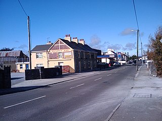
Beggars Bush is the site of the former Beggars Bush Barracks on Haddington Road in the inner southern suburbs of Dublin, Ireland, as well the surrounding area and a nearby pub. The barracks were bordered to the east by Shelbourne Road, which used to be the western bank of the River Dodder. The locality is in the jurisdiction of Dublin City Council, is broadly considered to be part of Ballsbridge, and is in the postal district Dublin 4.

<span class="mw-page-title-main">Edmond Fitzmaurice, 1st Baron Fitzmaurice</span> British politician

Edmond George Petty-Fitzmaurice, 1st Baron Fitzmaurice,, styled Lord Edmond FitzMaurice from 1863 to 1906, was a British Liberal politician. He served as Under-Secretary of State for Foreign Affairs from 1883 to 1885 and again from 1905 to 1908, when he entered the cabinet as Chancellor of the Duchy of Lancaster under H. H. Asquith. However, illness forced him to resign the following year.

<span class="mw-page-title-main">Herbert Road</span>

Herbert Road in Ballsbridge, Ireland is a mostly residential road that links Tritonville Road with Lansdowne Road. Newbridge Avenue joins by the bridge, in front of Marian College and the former site of Sandymount High School next door. There are several hotels on the road. Noteworthy is the Mount Herbert Hotel which is a conversion of a terrace of stately homes. The road extends to the roundabout at the junction, which is part of Lansdowne Road. Both this road, and Newbridge Avenue, are built on the former site of Haigs' distillery.

<span class="mw-page-title-main">John Petty, 2nd Marquess of Lansdowne</span> British politician

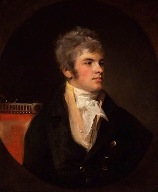
John Henry Petty, Earl Wycombe, 2nd Marquess of Lansdowne, was a British Whig politician who in Ireland was suspected of complicity in a republican conspiracy. In 1786, his father, the former British Prime Minister Lord Shelbourne, secured him an English seat in the House of Commons. After witnessing revolutionary events in Paris, he began to establish an independent reputation as a friend of reform, critical of the war with France and of the suppression of democratic agitation at home. In 1797 he repaired to his father's estates in Ireland where his political associations brought him under government surveillance.

<span class="mw-page-title-main">Derreen Garden</span>

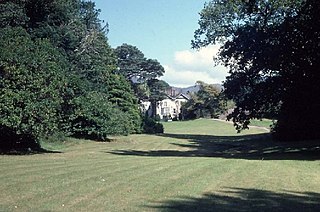
Derreen Garden lies on a promontory in Kilmakilloge Harbour on the Beara Peninsula, in Tuosist parish, near Kenmare in County Kerry, Republic of Ireland. The 4th Marquess of Lansdowne (1816–1866) initiated the planting of the garden in 1863, but it was his son and heir, The 5th Marquess of Lansdowne (1845–1927), who in his time served as Governor General of Canada, Viceroy of India, and British Secretary of State for Foreign Affairs, who from 1870 onwards gave the garden its present shape. Today it covers more than 60 acres and includes nearly 12 km of paths.

Francis Thomas-Fitzmaurice, 3rd Earl of Kerry was an Irish peer. He was the heir to a great inheritance, but his extravagance led to the loss of all his Irish estates.

<i>The Life of Sir William Petty, 1623–1687</i>

The Life of Sir William Petty 1623-1687 is a book, written by Lord Edmond Fitzmaurice, and published in 1895. It is a biography of Sir William Petty, the 17th-century scientist, known for his inventions, his charting of large parts of Ireland, in the Down Survey, and his publications on many different topics, like "political arithmetic" and political economy.

References

  1. "Bóthar Shíol Bhroin". logainm.ie.
  2. Encyclopaedia of Dublin - Douglas Bennett
  3. "Beggars Bush" . Retrieved 28 June 2011.
  4. "The many addresses of James Joyce". Comhairle Cathrach Bhaile Átha Cliath - Dublin City Council. 2 February 2022. Retrieved 3 November 2023.
  5. Ask About Ireland Website "AAI | Transport". Archived from the original on 23 November 2007. Retrieved 3 August 2009.