
The Northside in an informal but commonly used term to describe the part of the city of Dublin that lies to the north of the River Liffey, and extending into part of North County Dublin. The part outside the city is within the county of Fingal, a local government area established in 1994. While it is sometimes regarded as less wealthy than the city's Southside, the Northside was originally the home of the city's upper classes and the more privileged of the two. Today, some of the wealthiest areas in Ireland, such as Malahide, Howth, Clontarf, and Castleknock, lie north of the river.

Institute of Technology, Blanchardstown (ITB) established in 1999, was a third-level institution, now amalgamated into Technological University Dublin. It was the last-founded Institute of Technology in Ireland. The campus is located within the Business and Technology Park on Blanchardstown Road North, about 15 km from Dublin City and close to the N3. This is situated in the townland of Buzzardstown, in the civil parish of Mulhuddart.
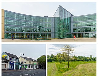
Blanchardstown is a large outer suburb of Dublin in the modern county of Fingal, Ireland. Located ten kilometres (6 mi) northwest of Dublin city centre, it has developed since the 1960s from a small village to a point where Greater Blanchardstown is the largest urban area in Fingal.

Mulhuddart is an outer suburb situated 12 km north-west of Dublin, Ireland. The River Tolka passes near the village.

Clonsilla is an outer suburb of Dublin in Fingal, Ireland.

Dublin 15, also rendered as D15, is a postal district in the suburbs of Dublin in Fingal, Ireland. It is 11 km (6.8 mi) west of the GPO in Dublin city.
Coolmine is a primarily residential suburb of Dublin, Ireland, in the jurisdiction of Fingal. It is also a townland in the civil parish of Clonsilla.

Tyrrelstown is a townland in Fingal, County Dublin, Ireland, in the civil parish of Mulhuddart. It is located 13 km northwest of the city of Dublin, and is often considered as part of the greater Blanchardstown area. It is the site of a planned suburban development from the early 2000s. It is in the Dublin postal district of Dublin 15
Kingswood is a suburban area in County Dublin, Ireland, in the local government area of South Dublin. It is a suburb of Tallaght, the county town of South Dublin

Ongar is an outer western suburb of Dublin, Ireland. Developed on a greenfield basis since 2001, it comprises the townlands of Castaheany (northerly) and "Hansfield or Phibblestown" (southerly), within the ancient Barony of Castleknock, County Dublin. It is close to Castleknock, Blanchardstown and Clonsilla. The development has a number of amenities on the main street, there are several schools in the area, and the nearby railway line at Hansfield railway station connects to the Luas Green Line and ultimately the N3 national route / M3 motorway. Employers in the nearby business parks and Greater Blanchardstown include Intel, Hewlett-Packard, IBM, Kepak and eBay.
Clonee is a village and a townland in County Meath, Ireland. It borders County Dublin to the east at the townlands of Huntstown and Littlepace, and is sometimes used in addresses for housing in those townlands. The River Tolka passes the village.
Corduff is a northwestern suburb of Dublin, in Fingal, Ireland, 10 km from Dublin city centre. It is a part of the wider Blanchardstown area and is in the Dublin 15 postal district.

Hansfield railway station is a railway station in County Dublin, Ireland. It lies on the Docklands to M3 Parkway Commuter service and serves housing estates including Hansfield, Ongar, Littlepace, and Barnwell, among others; it is also the station nearest Clonee.

St Peregrine's GAA, also known as Cumann Naomh Peregrine C.L.G., is a Gaelic Athletic Association club in Clonsilla, Fingal, Ireland.
The barony of Castleknock is one of the baronies of Ireland. Originally part of the Lordship of Meath, it was then constituted as part of County Dublin. Today, it is in the modern county of Fingal, Ireland. The barony was originally also a feudal title, which became one of the subsidiary titles of the Viscounts Gormanston.

St Thomas, the Apostle parish is an ecclesiastical parish in the Blanchardstown deanery of the Roman Catholic Archdiocese of Dublin. It is served by the church of "St Thomas, the Apostle". The parish is centered on "Laurel Lodge" district and the townland of Carpenterstown in the civil parish of Castleknock, Fingal in Ireland. On 6 June 2018, the Archbishop of Dublin, Diarmuid Martin, concelebrated mass in the parish church on the occasion of the 25th anniversary of the laying of the building's foundation stone.

Hartstown Community School is an Irish Secondary School located in Hartstown, Clonsilla. It serves the area of Hartstown, Huntstown and other localities in the Clonsilla suburb.
Castleknock is a civil parish and a townland located in the south-western corner of the modern county of Fingal, Ireland. The civil parish is part of the ancient barony of Castleknock. It is centred on the suburban village of Castleknock. The townland of Castleknock itself is the location of the eponymous "Cnucha's Castle" – Castleknock Castle. The town with the biggest population in the parish is Blanchardstown. In geology, the parish rests on a substratum of limestone and comprises 2943 statute acres, the whole of which is arable land.
Clonsilla or "Clonsillagh" is a civil parish and a townland located in the south-western corner of the modern county of Fingal, Ireland. The civil parish is part of the ancient barony of Castleknock. It is centred on the suburban village of Clonsilla. In geology, the parish rests on a substratum of limestone and comprises 2943 statute acres, the whole of which is arable land. It is roughly bounded to the north by the old "Navan Road" – the modern N3; to the east by the civil parish of Castleknock; to the south by the River Liffey; to the south-east by the civil parish of Leixlip, chiefly in County Kildare, and to the north-west by the civil parish of Dunboyne in County Meath.
