
The Northside in an informal but commonly used term to describe the part of the city of Dublin that lies to the north of the River Liffey, and extending into part of North County Dublin. The part outside the city is within the county of Fingal, a local government area established in 1994. While it is sometimes regarded as less wealthy than the city's Southside, the Northside was originally the home of the city's upper classes and the more privileged of the two. Today, some of the wealthiest areas in Ireland, such as Malahide, Howth, Clontarf, and Castleknock, lie north of the river.
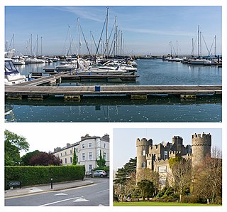
Malahide is an affluent coastal settlement in Fingal, County Dublin, Ireland, situated 14 kilometres north of Dublin city. It has a village centre surrounded by suburban housing estates, with a population of 18,608 as per the 2022 census.

Sutton is a residential suburb on the Northside of Dublin, Ireland. It occupies the tombolo which links Howth Head to the mainland, some of the lower slopes of Howth Hill, and a little of the adjacent coasts. The area lies within the jurisdiction of Fingal County Council. There is a small commercial core at the Sutton Cross road intersection.

Coolock is a large suburban area, centred on a village, on Dublin city's Northside in Ireland. Coolock is crossed by the Santry River, a prominent feature in the middle of the district, with a linear park and ponds. The Coolock suburban area encompasses parts of three Dublin postal districts: Dublin 5, Dublin 13 and Dublin 17.

Raheny is a northern suburb of Dublin, Ireland, halfway from the city centre to Howth. It is centred on a historic settlement, first documented in 570 AD. The district shares Dublin's two largest municipal parks, Saint Anne's Park and Bull Island with its 4.5 km beach, with neighbouring Clontarf, and is crossed by several small watercourses.

Baldoyle is a coastal suburb of Dublin's northside. It is located in the southeastern part of the jurisdiction of Fingal, Ireland, developed from a former fishing village.

Artane, sometimes spelt Artaine, historically Tartaine is a northside suburb of Dublin city, Ireland.
Kilbarrack is a residential suburb of Dublin, Ireland, running inwards from the coast, about 8 km (5.0 mi) from the city's centre. It is also a civil parish in the ancient barony of Coolock. Modern-day Kilbarrack is within the jurisdiction of Dublin City Council, with part of its old lands now in Donaghmede, and part in Bayside under Fingal County Council jurisdiction.
Donaghmede is a mixed socio-economic residential suburb on the northern side of Dublin, Ireland, formed from parts of Baldoyle, Coolock and Raheny in the 1970s. It contains a mid-size shopping centre and a ruined chapel, and lies within the jurisdiction of Dublin City Council.
Killester is a small residential suburb of Dublin, Ireland on the Northside of the city in the Dublin 3 and Dublin 5 postal districts. It was the site of a church and convent or monastery centuries ago, and later a small village developed. In 1922, a settlement for ex-servicemen and their families was established, and the area grew with suburban housing later. The local parish church has for many years hosted a relic of St Brigid.
Beaumont is a northside suburb of Dublin city, Ireland, bordered by Donnycarney, Santry and Artane. It lies within the postal district of Dublin 9.
Donnycarney is a Northside suburb in the city of Dublin, Ireland, in the jurisdiction of Dublin City Council. It is mostly residential, around 5 kilometres (3.1 mi) from the centre of Dublin. Dublin GAA's home stadium, Parnell Park, is located here.
Balgriffin is a suburb of Dublin, Ireland. It lies on the administrative boundary between Dublin City and the county of Fingal in the traditional County Dublin.

Kinsealy is an outer suburb of Dublin in Fingal, Ireland. Kinsealy is on the northside of the city, about 13 km from the city centre, on the Malahide Road, in the former green belt between the suburbs of Balgriffin, Portmarnock and Malahide.

Clongriffin is a community in northern Donaghmede, on the northern fringe of Dublin, Ireland. The settlement was based on a master plan vision from major developer Gannon Homes, with significant investment in transport infrastructure and also community and recreational amenities. Development slowed during the downturn in the economy, although activity renewed in recent years, with planning permission secured for a hotel and a range of additional homes including a 16-storey apartment block with residential lounges and roof gardens..
Priorswood is a townland and district in northern Coolock, on the Northside of Dublin, Ireland. It is in the jurisdiction of Dublin City Council and forms part of the Dublin 17 postal district.

The R107 road is a regional road in north Dublin, Ireland with a length of 10.5 kilometres (6.5 mi). It traverses a route from Fairview to Malahide, via Coolock, Balgriffin, and ultimately reaches the western edge of Portmarnock. Its main component is the Malahide Road.
Belcamp Park is a public park in Clonshaugh, Dublin 17, within the broad Coolock area, near Darndale and Priorswood. The park runs south of the N32, along the northern boundary of the city. It is owned by Dublin City Council and operated by the Council's Parks and Landscape Division.
Coolock is one of the baronies of Ireland. It was constituted as part of the old county of Dublin. Today, it covers much of the northern parts of the city of Dublin and the south-eastern part of the modern county of Fingal. At the heart of the barony is the civil parish of the same name - Coolock - which is one of twenty civil parishes in the barony.

Belcamp House is a Georgian house and former school, situated within a substantial estate off the Malahide Road in Balgriffin in the northern suburbs of Dublin, Ireland. The house was designed by the architect James Hoban, who also designed the White House in Washington, D.C., with a similar Oval Office utilising the bow back of the building.

