Burrow Beach

Last updated

Burrow Beach
Hole in the Wall Beach [1]
Sutton beach1.jpg
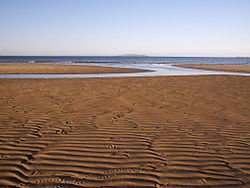
The beach facing north to Lambay island at low tide
Ireland adm location map.svg
Red pog.svg
Location in Ireland
Location Sutton, Dublin
Coordinates 53°23′33″N6°06′06″W / 53.3925°N 6.1017°W / 53.3925; -6.1017 Coordinates: 53°23′33″N6°06′06″W / 53.3925°N 6.1017°W / 53.3925; -6.1017
Length1.2km
GeologyBeach
AccessFrom Burrow Road

Burrow Beach, also known as the Hole in the Wall locally, is a beach in Sutton, in Fingal, County Dublin, Ireland. It neighbours Claremont Beach by Howth village, and, across the water (the exit of the inlet of Baldoyle Bay), Portmarnock Strand. It is served by a lifeguard during the summer months and is a green flag beach.

Contents

Location and geography

The beach is located on the north side of the Tombolo of Sutton which connects Howth Head to the mainland. It is a sandy beach and contains a large area of sand dunes. It is 1.2 km long. [2]

Ireland's Eye seen from the beach Sutton beach2.jpg
Ireland's Eye seen from the beach

The beach is served by the DART, as Sutton Station is a walkable distance away. [3] Its main entrance is located on the Burrow road. It is also served by Dublin Bus route 31 and its variants from Sutton Cross, as well as route 102 which terminates at the DART station.

See also

Related Research Articles

Dublin Area Rapid Transit Commuter rail network in Dublin, Ireland

The Dublin Area Rapid Transit system is an electrified commuter rail railway network serving the coastline and city of Dublin, Ireland. The service makes up the core of Dublin's suburban railway network, stretching from Greystones, County Wicklow, in the south to Howth and Malahide in north County Dublin. The DART serves 31 stations and consists of 53 route kilometres of electrified railway, and carries in the region of 20 million passengers per year.

Northside, Dublin Unofficial description of Dublin city north of the River Liffey

The Northside is the part of Dublin city that lies to the north of the River Liffey. It is an informal but commonly used term. While it is sometimes regarded as less wealthy than the city's Southside, the Northside was originally the home of the city's upper classes and the more privileged of the two. Today, some of the wealthiest areas in Ireland lie north of the river, such as Malahide, Howth, Clontarf, and Castleknock.

Malahide Suburban settlement north of Dublin, Ireland

Malahide is an affluent coastal settlement in Fingal, County Dublin, Ireland, situated 14 kilometres (9 mi) north of Dublin city. It has a village centre surrounded by suburban housing estates, with a population of over 17,000.

Sutton, Dublin Residential suburb of Dublin, Ireland

Sutton is a residential suburb on the Northside of Dublin, Ireland. It occupies the tombolo which links Howth Head to the mainland, some of the lower slopes of Howth Hill, and a little of the adjacent coasts. The area lies within the jurisdiction of Fingal County Council. There is a small commercial core at the Sutton Cross road intersection.

Howth Peninsular suburb of Dublin

Howth is an affluent peninsular village and outer suburb of Dublin, Ireland. The district as a whole occupies the greater part of the peninsula of Howth Head, which forms the northern boundary of Dublin Bay, and includes the island of Ireland's Eye, which holds multiple natural protection designations.

Howth Head Peninsula northeast of Dublin, Ireland

Howth Head is a peninsula northeast of the city of Dublin in Ireland, within the governance of Fingal County Council. Entry to the headland is at Sutton while the village of Howth and the harbour are on the north-eastern face. Most of Howth Head is occupied by the Hill of Howth, though there are other regions, such as the tombolo at Sutton, extensive beaches on the northern shores, and small ones in other parts. The Baily Lighthouse is on the southeastern part of Howth Head. Nearby are the districts of Baldoyle and Portmarnock, and adjacent is the nature reserve of North Bull Island.

Baldoyle Coastal north-eastern suburb of Dublin, Ireland

Baldoyle is a coastal suburb of Dublin's northside. It is located in the southeastern part of the jurisdiction of Fingal, Ireland, developed from a former fishing village.

Irelands Eye Marine island in County Dublin, Ireland

Ireland's Eye is a small long-uninhabited island off the coast of County Dublin, Ireland. Situated directly north of Howth village and harbour, the island is easily reached by regular seasonal tourist boats, which both circumnavigate it and drop off day trippers. There is a yacht anchorage to the north of it, and kayakers also land.

Bayside is a small modern residential suburb on the Northside of Dublin, Ireland, commenced in 1967.

Sutton Park is on the coastline of Dublin Bay, Ireland.

Hill of Howth Tramway

The Howth Tram on the Hill of Howth Tramway was a tram which served Howth Head, near Dublin, Ireland. The termini were at Sutton railway station, by the entrance to the peninsula, and Howth railway station by the village and harbour of Howth.

Kilbarrack is a residential suburb of Dublin, Ireland, running inwards from the coast, about 8 km (5.0 mi) from the city's centre. It is also a civil parish in the ancient barony of Coolock. Modern-day Kilbarrack is within the jurisdiction of Dublin City Council, with part of its old lands now in Donaghmede, and part in Bayside under Fingal County Council jurisdiction.

Howth railway station

Howth DART station, is a railway station in Fingal, Ireland that serves Howth village and one side of Howth Head.

Fingal County Council Local government authority for county of Fingal in Ireland

Fingal County Council is the authority responsible for local government in the county of Fingal, Ireland. It is one of three local authorities that comprised the former Dublin County Council before its abolition on 1 January 1994 and is one of four local authorities in County Dublin. As a county council, it is governed by the Local Government Act 2001. The council is responsible for housing and community, roads and transport, urban planning and development, amenity and culture, and environment. The council has 40 elected members. Elections are held every five years and are by single transferable vote. The head of the council has the title of Mayor. The county administration is headed by a Chief Executive, AnnMarie Farrelly. The county town is Swords.

Portmarnock Coastal outer suburban village north of Dublin, Ireland

Portmarnock is a coastal suburban settlement in Fingal, Ireland, with significant beaches, a modest commercial core and inland residential estates, and two golf courses, including one of Ireland's best-known golf clubs. As of 2016, the population was 9,466, an increase on the Census 2011 figure of 9,285.

R107 road (Ireland) Regional road in Dublin, Ireland

The R107 road is a regional road in north Dublin, Ireland with a length of 10.5 kilometres (6.5 mi). It traverses a route from Fairview to Malahide, via Coolock, Balgriffin, and ultimately reaches the western edge of Portmarnock. Its main component is the Malahide Road.

R105 road (Ireland)

The R105 road is a regional road in north Dublin, Ireland. It travels from the city centre to Howth, and loops at both ends; the road fully encircles Howth Head. Along the way, the road passes through Fairview, the western end of Clontarf, Killester, Raheny, the coastal edge of Kilbarrack and Sutton. Its biggest component is Howth Road.

Baldoyle Bay Sea inlet and nature reserve north of Dublin, Ireland

Baldoyle Bay is a sea inlet on the east coast of Fingal in Ireland, in the historic County Dublin. It is situated between Portmarnock, at its head, and Baldoyle. It contains two small estuaries, those of the Sluice River and the Mayne River, and is sometimes called Baldoyle Estuary. The inlet is an important natural feature with protected status. It was once the site of a Viking longphort and later the fishing village of Baldoyle developed near its outlet to the sea.

Sutton Castle, Dublin Castellated mansion house

Sutton Castle or Sutton House is a Victorian Tudor-style castellated mansion house with terraced gardens on the southern coast of Howth Head, overlooking Dublin Bay, in the suburbs of Dublin, Ireland.

Corr Castle Tower house in Sutton, Dublin

Corr Castle is an L-plan tower house likely constructed sometime in the fifteenth century in Sutton, Dublin. The castle lies within the boundaries of Howth Demesne in the old townland of Correston, close to the townlands of Quarry and Burrow. The castle was probably built on higher ground in order to guard the isthmus at Sutton which was the only route on land to access Howth Castle and the port of Howth. It has historically sometimes been called The Dane's castle.

References

  1. "Top Dublin Seaside Trips To Take Before You Die". lovindublin.com. Retrieved 2 June 2020.
  2. Discover Ireland. "Burrow Beach Green Coast Award 2017" . Retrieved 8 December 2017.
  3. Fingal County Council. "Burrow Beach information".