Carmarthen Bay is an inlet of the South Wales coast, including notable beaches such as Pendine Sands and Cefn Sidan sands. Carmarthen Bay is partially within the Pembrokeshire Coast National Park. The Joint Nature Conservation Committee list Carmarthen Bay and Estuaries as a Special Area of Conservation.

Coos Bay is an estuary where the Coos River enters the Pacific Ocean, the estuary is approximately 12 miles long and up to two miles wide. It is the largest estuary completely within Oregon state lines. The Coos Bay watershed covers an area of about 600 square miles and is located in northern Coos County, Oregon in the United States. The Coos River, which begins in the Oregon Coast Range, enters the bay from the east. From Coos River, the bay forms a sharp loop northward before arching back to the south and out to the Pacific Ocean. Haynes Inlet enters the top of this loop. South Slough branches off from the bay directly before its entrance into the Pacific Ocean. The bay was formed when sea levels rose over 20,000 years ago at the end of the Last Glacial Maximum, flooding the mouth of the Coos River. Coos Bay is Oregon's most important coastal industrial center and international shipping port, with close ties to San Francisco, the Columbia River, Puget Sound and other major ports of the Pacific rim.

Donabate is a small coastal town in Fingal, Ireland, about 20 kilometres north-northeast of Dublin. The town is on a peninsula on Ireland's east coast, between the Rogerstown Estuary to the north and Broadmeadow Estuary to the south. Donabate is a civil parish in the ancient barony of Nethercross.
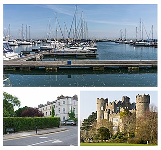
Malahide is an affluent coastal settlement in Fingal, County Dublin, Ireland, situated 14 kilometres (9 mi) north of Dublin city. It has a village centre surrounded by suburban housing estates, with a population of 18,608 as per the 2022 census.

Baldoyle is a coastal suburb of Dublin's northside. It is located in the southeastern part of the jurisdiction of Fingal, Ireland, developed from a former fishing village.
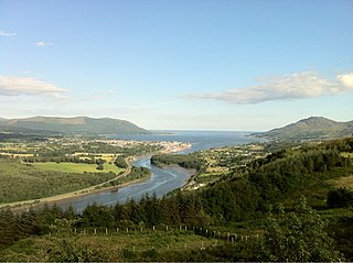
Carlingford Lough is a glacial fjord or sea inlet in northeastern Ireland, forming part of the border between Northern Ireland to the north and the Republic of Ireland to the south. On its northern shore is County Down, the Mourne Mountains, and the town of Warrenpoint; on its southern shore is County Louth, the Cooley Mountains and the village of Carlingford. The Newry River flows into the loch from the northwest.

Rogerstown Estuary is a sea inlet and estuary in Ireland. It is situated just north of the Donabate-Portrane peninsula, and also south of Rush, on Ireland's east coast about 25 km (16 mi) north of Dublin. It is a designated nature reserve, Special Area of Conservation, and a Ramsar site.

Great Bay is located in southern New Jersey's Atlantic Coastal Plain in Ocean and Atlantic Counties, about ten miles (16 km) north of Atlantic City and 87 mi (140 km) south of New York City. The Mullica River flows into the bay, and together they form the Mullica River - Great Bay estuary habitat. The bay is connected to the Atlantic Ocean via the Little Egg Inlet. Great Bay is considered one of the least-disturbed marine wetlands habitats in the northeastern United States.

Santry River is a small watercourse on the north side of Dublin city, one of the forty or so watercourses monitored by Dublin City Council. It runs, mostly unculverted, from Harristown and Dubber near Dublin Airport, through Santry and Coolock, reaching the sea at Raheny, in a lagoon area inshore of Bull Island.

Elkhorn Slough is a 7-mile-long (11 km) tidal slough and estuary on Monterey Bay in Monterey County, California. It is California's second largest estuary and the United States' first estuarine sanctuary. The community of Moss Landing and the Moss Landing Power Plant are located at the mouth of the slough on the bay.

Clongriffin is a community in northern Donaghmede, on the northern fringe of Dublin, Ireland. The settlement was based on a master plan vision from major developer Gannon Homes, with significant investment in transport infrastructure and also community and recreational amenities. Development slowed during the downturn in the economy, although activity renewed in recent years, with planning permission secured for a hotel and a range of additional homes including a 16-storey apartment block with residential lounges and roof gardens..

Booterstown Marsh, a Nature Reserve, is located in Booterstown, County Dublin, between the coastal railway line and the Rock Road. It is an area of salt marsh and muds, with brackish water. It includes the only salt marsh, and the only bird sanctuary, in south Dublin Bay. It lies just outside the boundary of Dublin city, and just north of Booterstown DART station and its car park.

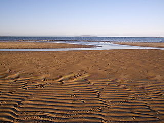
Dundalk Bay is a large (33 km2), exposed estuary on the east coast of Ireland. The inner bay is shallow, sandy and intertidal, though it slopes into a deeper area 2 km from the transitional water boundary. It is predominantly influenced by the sea, though several rivers drain into the bay from the west. In the northwest corner of the bay, the Castletown River cuts through the intertidal zone and the smaller River Fane flows into the southeast corner. While the shores of the bay are largely made up of intertidal flats, there is a significant area of salt marsh on the western shore. The catchment around the bay is of mixed agriculture and urban land use.

Father Collins Park is a public park located in Dublin, Ireland, near the boundary of Dublin city and Fingal. Its official address is Donaghmede, and it is located near the new development at Clongriffin, with Balgriffin a little to the west. It is owned and managed by Dublin City Council.

Broadhaven Bay is a natural bay of the Atlantic Ocean on the northwestern coast of County Mayo, Ireland. The opening of the bay faces northward, stretching 8.6 km between Erris Head in the west and Kid Island/Oileán Mionnán in the east.

The Dublin Bay Biosphere Reserve is a biosphere reserve comprising Dublin Bay, North Bull Island and adjacent land, including parts of Dublin, the capital city of Ireland, and the outfalls of multiple rivers. It contains one of the finest sand dune systems on the island of Ireland, and is internationally important in terms of its conservation value. There are high quality examples of several rare and threatened coastal habitats present within its area.
Burrow Beach, also known as the Hole in the Wall locally, is a beach in Sutton, in Fingal, County Dublin, Ireland. It neighbours Claremont Beach by Howth village, and, across the water, Portmarnock Strand. It is served by a lifeguard during the summer months and is a green flag beach.

Boundary Bay Wildlife Management Area is a wildlife management area encompassing the entire Canadian portion of Boundary Bay in the Lower Mainland of British Columbia. It was established by the British Columbia Ministry of Forests, Lands, Natural Resource Operations and Rural Development (FLNRORD) on 21 June 1995 to conserve critical habitat for migratory bird species and resident fish and marine mammal species. It is part of the larger Fraser River Delta Ramsar Site.
Milford Haven Waterway, is a Site of Special Scientific Interest (SSSI) on Milford Haven Waterway in Pembrokeshire, South Wales, designated since 2002. The site is protected for a wide range of reasons, including its geology, marine environment and ecosystems, and to protect a diversity of flora and fauna.
The Mayne River, is a small watercourse of northern County Dublin. It forms from the merger of the Cuckoo and Turnapin Streams, which rise near Dublin Airport and help drain the airport campus. The river is in the jurisdiction of Fingal County Council and within the oversight of the Environmental Protection Agency.