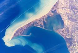
Long Point is a sand spit and medium-sized hamlet on the north shore of Lake Erie, part of Norfolk County in the province of Ontario, Canada.
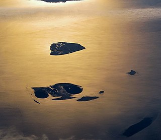
The Hamburg Wadden Sea National Park is the smallest of the three German Wadden Sea National Parks which protect the single ecological entity of the Wadden Sea reaching from Den Helder to Esbjerg.
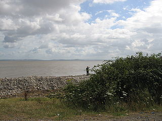
Bridgwater Bay is on the Bristol Channel, 5 kilometres (3.1 mi) north of Bridgwater in Somerset, England at the mouth of the River Parrett and the end of the River Parrett Trail. It stretches from Minehead at the southwestern end of the bay to Brean Down in the north. The area consists of large areas of mudflats, saltmarsh, sandflats and shingle ridges, some of which are vegetated. It has been designated as a Site of Special Scientific Interest (SSSI) covering an area of 3,574.1 hectares since 1989, and is designated as a wetland of international importance under the Ramsar Convention. The risks to wildlife are highlighted in the local Oil Spill Contingency Plan.

Dublin Bay is a C-shaped inlet of the Irish Sea on the east coast of Ireland. The bay is about 10 kilometres wide along its north–south base, and 7 km in length to its apex at the centre of the city of Dublin; stretching from Howth Head in the north to Dalkey Point in the south. North Bull Island is situated in the northwest part of the bay, where one of two major inshore sand banks lay, and features a 5 km long sandy beach, Dollymount Strand, fronting an internationally recognised wildfowl reserve. Many of the rivers of Dublin reach the Irish Sea at Dublin Bay: the River Liffey, with the River Dodder flow received less than 1 km inland, River Tolka, and various smaller rivers and streams.
The Mud Islands reserve is located within Port Phillip, about 90 km (56 mi) south-west of Melbourne, Australia, lying 10 km (6.2 mi) inside Port Phillip Heads, 7 km (4.3 mi) north of Portsea and 9 km (5.6 mi) east of Queenscliff. The land area of about 50 hectares is made up of three low-lying islands surrounding a shallow tidal 35-hectare (86-acre) lagoon connected to the sea by three narrow channels. The shapes and configuration of the islands change over the years due to movement of sand by tidal currents.
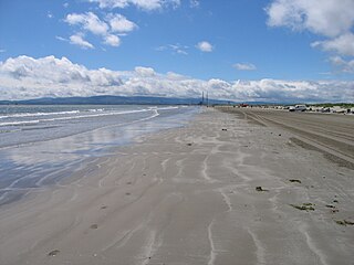
Bull Island, more properly North Bull Island, is an island located in Dublin Bay in Ireland, about 5 km long and 800 m wide, lying roughly parallel to the shore off Clontarf, Raheny, Kilbarrack, and facing Sutton. The island, with a sandy beach known as Dollymount Strand running its entire length, is a relatively recent, and inadvertent, result of human intervention in the bay. The island lies within the jurisdiction of, and is mostly owned by, Dublin City Council, and is managed by the Council's Parks and Landscape Division.

Braunton Burrows is a sand dune system on the North Devon coast. It is privately owned and forms part of the Christie Devon Estates Trust. Braunton Burrows is a prime British sand dune site, the largest sand dune system (psammosere) in England. It is particularly important ecologically because it includes the complete successional range of dune plant communities, with over 470 vascular plant species. The short turf communities are very rich in lichens and herbs, and the dune slacks are also rich. The many rare plants and animals include 14 with UK Biodiversity Action Plans. For example, this is one of only two sites in the UK for the Amber Sandbowl Snail Catinella arenaria, which is found on the wet dune slacks.

The Ribble and Alt Estuaries lie on the Irish Sea coast of the ceremonial counties of Lancashire and Merseyside in the traditional county of Lancashire in north-west England, and form the boundaries of a number of conservation schemes.

The Golden Gate Biosphere Network is an internationally recognized voluntary coalition of federal, state, and local government agencies, nonprofit organizations, universities, and private partners within the Golden Gate Biosphere region. The Network works towards protecting the biosphere region's biodiversity and conserving its natural resources to maintain the quality of life for people within the region. The Network has been part of the UNESCO Man and Biosphere Programme since 1988 and is part of the US Biosphere Network and EuroMAB. It is recognized by UNESCO due to the significant biodiversity of the region, as well as the Network's efforts to demonstrate and promote a balanced relationship between humans and the biosphere.

Miyānkāle peninsula is a long, narrow peninsula in Behshahr County of Māzandarān Province in the north of Iran situated in the extreme south-eastern part of the Caspian Sea. The elongate peninsula is 48 kilometres long, and between 1.3 and 3.2 kilometres wide.

The Long Point Biosphere Reserve is located in southern Canada on the shores of Lake Erie in Norfolk County. The area encompasses a rich mosaic of ecological systems associated with erosion deposit sand spit formations around the Laurentian Great Lakes, as well as some of the largest remaining forest tracts in "Carolinian Canada". The variety of habitats supports a rich flora and fauna, including a waterfowl staging area and a migration stopover area for land birds of continental importance. Long Point Biosphere Reserve has been recognized as a Ramsar site and as a globally significant Important Bird Area by Bird Life International. Established in 1960, the bird observatory is the oldest, continuously operated, in North America.

The Bull Wall, or North Bull Wall, at the Port of Dublin, extending from the estuary of the River Tolka and the district of Clontarf out nearly 3 km into Dublin Bay, is one of the two defining sea walls of the port, and faces the earlier-constructed Great South Wall. It has one of a trio of port lighthouses at the end of its extension breakwater, and a statue of Realt na Mara partway along, and was responsible for the formation of North Bull Island with its nearly 5 km of beach.
Akyatan Lagoon is a 14700-hectare wetland ecosystem that is designated as Wetland of International Importance by Ramsar Convention. A major stop over for migrating birds, Akyatan is recognized as an Important Bird Area by BirdLife International. It is the single largest green turtle rookery at the Mediterranean, holding 43% of the Mediterranean nesting population.

Baldoyle Bay is a sea inlet on the east coast of Fingal in Ireland, in the historic County Dublin. It is situated between Portmarnock, at its head, and Baldoyle. It contains two small estuaries, those of the Sluice River and the Mayne River, and is sometimes called Baldoyle Estuary. The inlet is an important natural feature with protected status. It was once the site of a Viking longphort and later the fishing village of Baldoyle developed near its outlet to the sea.

North Devon's Biosphere Reserve is a UNESCO biosphere reserve in North Devon. It covers 55 square miles (140 km2) and is centred on Braunton Burrows, the largest sand dune system (psammosere) in England. The boundaries of the reserve follow the edges of the conjoined catchment basin of the Rivers Taw and the Torridge and stretch out to sea to include the island of Lundy. The biosphere reserve is primarily lowland farmland, and includes many protected sites including 63 Sites of Special Scientific Interest which protect habitats such as culm grassland and broadleaved woodlands. The most populous settlements in its buffer area are Barnstaple, Bideford, Northam, Ilfracombe, and Okehampton.

The Waddensea of Hamburg between Elbe and Weser is a German Biosphere reserve. It was added in 1992 by the UNESCO in their "man and biosphere" (MAB).
The Lake Tana Biosphere Reserve is a protected area located in the Amhara National Regional State approximately 563 km northwest of Addis Ababa in the north-western part of Ethiopia. The biosphere reserve comprises Lake Tana, the largest lake in Ethiopia, the main source of the Blue Nile, which provides important ecosystem services. The area is a hotspot of biodiversity, internationally known as an Important Bird Area and is of global importance for agricultural genetic diversity. The area is characterized by an enormous heterogeneity of land uses and natural ecosystems.
The West Estonian Archipelago Biosphere Reserve is a UNESCO Biosphere Reserve in Estonia, located in the West Estonian archipelago in the eastern Baltic Sea. The 15,600 square kilometres (6,000 sq mi) reserve comprises the islands of Saaremaa, Hiiumaa, Vormsi and Muhu, as well as numerous islets and marine parts. The islands are in the transition zone between temperate needle-leaf and broadleaf forest.

The Petenes mangroves ecoregion covers mangrove habitat along the Gulf of Mexico coast of southern Mexico, where Campeche state and Yucatan state meet, centering on the Celestun Lagoon inland from the barrier-island town of Celestún. Because the region has relatively little rainfall and no rivers feeding the lagoons, the freshwater to support the mangrove ecosystem springs from underground aquifers. The area is important for migratory birds, and as a nesting area for sea turtles. The area around the Celestun Lagoon is protected by the Ría Celestún Biosphere Reserve, a UNESCO Biosphere Reserve.
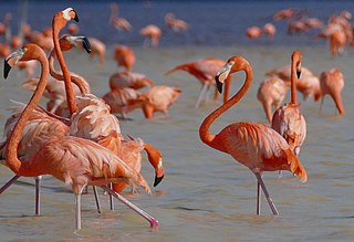
Ría Celestun Biosphere Reserve is a biosphere reserve in Mexico. It is located on the northwestern Yucatán Peninsula in the states of Yucatán and Campeche. The reserve is home to extensive mangrove wetlands, and rich in birds and other wildlife.


