County Dublin is a county in Ireland, and holds its capital city, Dublin. It is located on the island's east coast, within the province of Leinster. Until 1994, County Dublin was a single local government area; in that year, the county council was divided into three new administrative counties: Dún Laoghaire–Rathdown, Fingal and South Dublin. The three administrative counties together with Dublin City proper form a NUTS III statistical region of Ireland. County Dublin remains a single administrative unit for the purposes of the courts and Dublin County combined with Dublin City forms the Judicial County of Dublin, including Dublin Circuit Court, the Dublin County Registrar and the Dublin Metropolitan District Court. Dublin also sees law enforcement and fire services administered county-wide.

Dublin is the capital city of Ireland. On a bay at the mouth of the River Liffey, it is in the province of Leinster, bordered on the south by the Dublin Mountains, a part of the Wicklow Mountains range. At the 2022 census, the city council area had a population of 592,713, while Dublin City and its suburbs had a population of 1,263,219, and County Dublin had a population of 1,501,500, making it the largest city by population on the island of Ireland.

Glasnevin is a neighbourhood of Dublin, Ireland, situated on the River Tolka. While primarily residential, Glasnevin is also home to the National Botanic Gardens, Glasnevin Cemetery, the National Meteorological Office, and a range of other state bodies, and Dublin City University has its main campus and other facilities in and near the area. Glasnevin is also a civil parish in the ancient barony of Coolock.

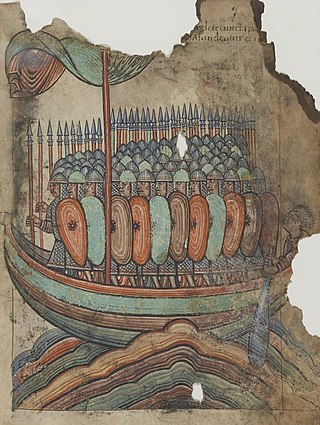
The Viking Age was the period during the Middle Ages when Norsemen known as Vikings undertook large-scale raiding, colonising, conquest, and trading throughout Europe and reached North America. The Viking Age applies not only to their homeland of Scandinavia but also to any place significantly settled by Scandinavians during the period. The Scandinavians of the Viking Age are often referred to as Vikings as well as Norsemen, although few of them were Vikings in the sense of being engaged in piracy.

Vikings were seafaring people originally from Scandinavia, who from the late 8th to the late 11th centuries raided, pirated, traded, and settled throughout parts of Europe. They also voyaged as far as the Mediterranean, North Africa, the Middle East, Greenland, and Vinland. In their countries of origin, and some of the countries they raided and settled in, this period is popularly known as the Viking Age, and the term "Viking" also commonly includes the inhabitants of the Scandinavian homelands as a whole. The Vikings had a profound impact on the early medieval history of Scandinavia, the British Isles, France, Estonia, and Kievan Rus'.

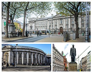
College Green is a three-sided plaza in the centre of Dublin, Ireland. On its northern side is the Bank of Ireland building, which until 1800 was Ireland's Parliament House. To its east stands Trinity College Dublin. To its south stands a series of 19th-century buildings.

The River Liffey is a river in eastern Ireland that ultimately flows through the centre of Dublin to its mouth within Dublin Bay. Its major tributaries include the River Dodder, the River Poddle and the River Camac. The river supplies much of Dublin's water and supports a range of recreational activities.

Ballyfermot is a suburb of Dublin, Ireland. It is located seven kilometres west of the city centre, south of Phoenix Park. It is bordered by Chapelizod on the north, by Bluebell on the south, by Inchicore on the east, and by Palmerstown and Clondalkin on the west. The River Liffey lies to the north, and the Grand Canal, now a recreational waterway, lies to the south of Ballyfermot. Ballyfermont lies within the postal district Dublin 10. Cherry Orchard, which is also a suburb, is sometimes considered to be within Ballyfermot.

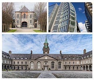
Kilmainham is a south inner suburb of Dublin, Ireland, south of the River Liffey and west of the city centre. It is in the city's Dublin 8 postal district.

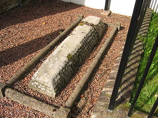
Hogbacks are stone carved Anglo-Scandinavian style sculptures from 10th- to 12th-century northern England and south-west Scotland. Singular hogbacks were found in Ireland and Wales. Hogbacks fell out of fashion by the beginning of the 11th century. Their function is generally accepted as grave markers. Similar later grave markers have been found in Scandinavia. In Cornwall similar stones are known as coped stones.

The Kingdom of Dublin was a Norse kingdom in Ireland that lasted from roughly 853 AD to 1170 AD. It was the first and longest-lasting Norse kingdom in Ireland, founded by Vikings who invaded the territory around Dublin in the 9th century. Its territory corresponded to most of present-day County Dublin.

Howth Castle is a historic dwelling, originally of Norman origin, that lies by the village of Howth, County Dublin, Ireland; it is sited within a substantial estate. The castle was the ancestral home of the St Lawrence family that had held the area since the Norman Invasion of 1180, and the head of which held the title of Lord Howth, a feudal barony, until circa 1425, Baron Howth to 1767, then Earl of Howth until 1909. The castle and estate were held by distaff heirs, the Gaisford-St Lawrence family, from 1909 to 2019, when they were sold to Tetrarch Capital.

Island Bridge, formerly Sarah or Sarah's Bridge, is a road bridge spanning the River Liffey, in Dublin, Ireland which joins the South Circular Road to Conyngham Road at the Phoenix Park.

The Irish National War Memorial Gardens is an Irish war memorial in Islandbridge, Dublin, dedicated "to the memory of the 49,400 Irish soldiers who gave their lives in the Great War, 1914–1918", out of a total of 206,000 Irishmen who served in the British forces alone during the war.

Sir Philip Crampton, 1st Baronet, FRSMRCSI was an eminent Irish surgeon and anatomist. He was President of the Royal College of Surgeons in Ireland (RCSI) in 1811, 1820, 1844 and 1855.
The Priory of All Hallows was a monastic foundation just outside of the walls of Dublin, Ireland.

The Old Steine is a thoroughfare in Brighton city centre, East Sussex, and is the southern terminus of the A23. The southern end leads to Marine Parade, the Brighton seafront and the Palace Pier. The Old Steine is also the site of a number of City Centre bus stops for Brighton buses. The Royal Pavilion is located immediately to the north of the Old Steine.

The Old Steine Gardens in Brighton, Brighton and Hove, East Sussex, England, adjacent to the Old Steine thoroughfare, are the site of several monuments of national historic significance.

Crampton Court, also colloquially known as Love Lane since the mid-2010s, is a short lane or passageway located in Temple Bar in central Dublin, Ireland. A small open-air square exists at approximately the halfway point of the lane, measuring approximately 11.5 by 16.7 metres wide, from which narrow, semi-covered lanes lead to its northern and southern entrances.


