
The River Shannon is the major river on the island of Ireland, and at 360 km in length, is the longest river in the British Isles. It drains the Shannon River Basin, which has an area of 16,900 km2 (6,525 sq mi), – approximately one fifth of the area of Ireland.
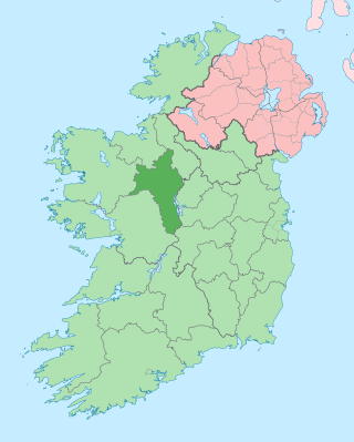
County Roscommon is a county in Ireland. It is part of the province of Connacht and the Northern and Western Region. It is the 11th largest Irish county by area and 26th most populous. Its county town and largest town is Roscommon. Roscommon County Council is the local authority for the county. The population of the county was 69,995 as of the 2022 census.

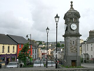
Carrick-on-Shannon is the county town of County Leitrim in Ireland. It is the largest town in the county. A smaller part of the town located on the west bank of the River Shannon lies in County Roscommon and is home to the towns main train station. As of the 2022 census, the population of the town was 4,743. It is situated on a strategic crossing point of the River Shannon. The main part of the town, the County Leitrim part, is in the civil parish of Kiltoghert, which is in the barony of Leitrim, while Cortober, which is the County Roscommon side of the town, is in the civil parish of Killukin, in the barony of Boyle.

Shown here are all the major rivers and tributaries of Ireland with their lengths. Starting with the Northern Ireland rivers, and going in a clockwise direction, the rivers are listed in regard to their entry into the different seas: the Irish Sea, the Celtic Sea and the Atlantic Ocean. Also shown are two tables. Table 1 shows the longest rivers in Ireland with their lengths, the counties they flow through, and their catchment areas. Table 2 shows the largest rivers in Ireland in cubic metres per second.
Boyle is a town in County Roscommon, Ireland. It is located at the foot of the Curlew Mountains near Lough Key in the north of the county. Carrowkeel Megalithic Cemetery, the Drumanone Dolmen and the lakes of Lough Arrow and Lough Gara are also close by. As of 2016, the population of the town was 2,568.

Lough Key is a lake in Ireland. It is in the northwest of County Roscommon, northeast of the town of Boyle. The lough is believed to be named after a mythical figure named Cé.

The River Suck is a river within the Shannon River Basin in Ireland, 133 km (82.5 mi) in length. It is the main tributary of the River Shannon. It meets the Shannon a kilometre south of the village of Shannonbridge.
Knockvicar is a village in County Roscommon, Ireland. It is located on the R285 regional road, between Boyle and Carrick-on-Shannon near Lough Key Forest Park in the north of the county.

Lough Gara is a lake in Counties Sligo and Roscommon, Ireland. It is an Important Bird Area protecting 1,788 ha of which most is covered by a Ramsar Site.

Ardcarn or Ardcarne is a civil parish in County Roscommon, Ireland, 8 km north-west of Carrick-on-Shannon.

The Miners' Way and Historical Trail is a long-distance trail in Ireland. It is a 118-kilometre (73-mile) long circular route that begins and ends in Arigna, County Roscommon. It is typically completed in five days. It is designated as a National Waymarked Trail by the National Trails Office of the Irish Sports Council and is managed by Roscommon Integrated Development Company, Roscommon County Council, Leitrim County Council and Sligo County Council. The trail was developed to encourage tourism in the area in the wake of the closure of the Arigna mines in 1990. The route was originally conceived by a local priest, Father Sean Tynan, and built with funding from the European Regional Development Fund. The trail was opened by broadcaster Donncha Ó Dúlaing in July 2000.
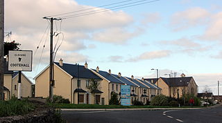
Cootehall is a village in County Roscommon, Ireland. It is located on the River Boyle, between Boyle and Carrick-on-Shannon near Lough Key Forest Park in the north of the county.

The Shannon River Basin consists of the area containing Ireland's longest river, the River Shannon, and all of its tributaries and lakes. The official Ordnance Survey Ireland length of the Shannon from its Shannon Pot source is 224 miles (360 km) made up of 63.5 miles (102.2 km) tidal water flow and 160.5 miles (258.3 km) freshwater flow.

The barony of Leitrim is a barony in County Leitrim, Ireland.

Urlaur Lough is a freshwater lake in the west of Ireland. It is located in east County Mayo and is one of the Urlaur Lakes.
Cavetown Lough is a freshwater lake in the west of Ireland. It is located in County Roscommon in the catchment of the upper River Shannon.

The Owenmore River is a river in County Sligo, Ireland. Its source is in the far south of Sligo, near Gorteen and Lough Gara, from which it runs for 52.3 km to its juncture with the Unshin River near Collooney to form the Ballisodare River. Its catchment covers 655 square kilometres (253 sq mi), predominantly located in Sligo but with small parts in County Mayo and County Roscommon. The catchment is underlain by limestone, and the total length of all the rivers in the Greater Owenmore Basin Area is 639 kilometres (397 mi). There are approximately 1,470 hectares (5.7 sq mi) of lakes in the catchment, with Lough Arrow comprising most of this.

Boyle is a barony in the far north of County Roscommon in Ireland.

The Lung is a river in Ireland flowing through counties Mayo and Roscommon. It runs in a generally north-easterly direction mainly through Mayo but also forms the border between the two counties in three places until it reaches Lough Gara near the town of Ballaghaderreen in County Roscommon. The river and its lakes provides facilities for anglers to fish.


