Jamestown, County Leitrim

Last updated • 3 min readFrom Wikipedia, The Free Encyclopedia

Jamestown
Cill Srianáin
Village
IMG JtownArch2832.jpg
The headless "arch"
Ireland adm location map.svg
Red pog.svg
Jamestown
Location in Ireland
Coordinates: 53°55′37″N8°01′46″W / 53.92694°N 8.02944°W / 53.92694; -8.02944
CountryIreland
Province Connacht
County County Leitrim
Elevation
40 m (130 ft)
Population
 (2002)
  Total229
Time zone UTC+0 (WET)
  Summer (DST) UTC-1 (IST (WEST))

Jamestown (Irish : Cill Srianáin) [1] is a village on the banks of the River Shannon in the south of County Leitrim, Ireland. It lies some 5 km east-south-east of the county town, Carrick-on-Shannon. It was named after King James VI & I.

Contents

Jamestown was built as a walled town during the Plantation of Leitrim for early to mid-seventeenth-century English settlers alongside the earlier settlement of Cill Srianáin, which had included an abbey. It used to be on the main Sligo to Dublin road (N4) and was known for the narrow pillars of the arch of the old town gate that straddles the road in the centre of the village. The arch was damaged by a passing lorry in the early 1970s and the top was removed. In recent years at Christmas, a lighted skeletal arch has been erected by the local community.

Two pubs and a church mark the centre of the village, close to the remains of the boundary walls. Jamestown lies beside the Shannon with its own quay and is a popular stopping point for boats. Navigation for cruisers is not possible downstream of Jamestown, boats being required to use the Jamestown Canal and Albert Lock, which links to the Shannon south of Drumsna

History

Ruins of Jamestown Friary, 1791 Jamestown Friary, Leitrim 1791.png
Ruins of Jamestown Friary, 1791

The Plantation settlement was created by Royal Charter from King James VI & I in 1621 and was founded in 1622 as a plantation town carrying into action the decision of 1620 to plant County Leitrim with loyal English settlers. It was granted to Sir Charles Coote, a Devonshire Planter, who fortified it with walls [2] twenty feet high and six feet in thickness, enclosing an area of about 4 acres (16,000 m2) which contained a castle. It had an area of 200 acres (0.81 km2) under its liberty.

A stone cross over a small gate (constructed by Murtagh O'Dowd, local blacksmith), outside the old town gate, leads to the remains of a Franciscan friary of the Friars Minor. The Franciscan friary of the Friars Minor was not founded until the occupation of Jamestown in 1642 by the O'Rourke Clan. A synod held here in 1650 repudiated The 1st Marquess of Ormonde, the former Lord Lieutenant of Ireland, and excommunicated his followers. In 1713, an elderly Father Connor Reynolds "of Jamestown in the county of Leitrim" exiled in Spain since 1681, was captured hiding in a trunk on a fishing boat arriving at Dungarvan port and imprisoned at Waterford gaol. [3]

The Borough with a very restricted franchise returned two members to the Irish Parliament until the Act of Union with Britain in 1801. Among its parliamentary representatives were Sir Charles Coote (1634–1660), John Fitzgibbon (1776; he was later elevated to the peerage in 1789, eventually becoming Earl of Clare in 1795), and Richard Martin, "Humanity Dick". The surnames Butler and Clyne are particularly numerous in the Jamestown area.

Throughout at least the nineteenth century and for much of the twentieth century, a number of annual fairs were held at Jamestown on- 28 May, 8 July, 1 September, and 20 December. [4] [5] In 1925, Jamestown village comprised 15 houses, 4 being licensed to sell alcohol. [6]

River crossings

Both Jamestown and Drumsna have long been important fording places across the Shannon. The present stone bridges were built during the 19th century as part of improvements to the Shannon navigation. The main Dublin - Sligo road ran across these until a bypass was completed in the late 1990s.

Doon of Drumsna

The Dún (Doon) of Drumsna, an Iron Age fortification built as a crossing point into Connacht, lies opposite the quay and runs across the Shannon peninsula between Jamestown and Drumsna. It was one of many linear earthworks built across the country around that time. The main rampart was massive with parts still standing up to 6 metres high and 30 metres across at the base. Additional banks were built on either side of the main rampart which extends for 1.6 kilometres. Two main entrances were built as pincer or Zangentor defensive works.

In addition to the main rampart, a secondary rampart extends upstream along the western river bank where shallows existed. [7]

See also

Related Research Articles

<span class="mw-page-title-main">County Leitrim</span> County in Ireland

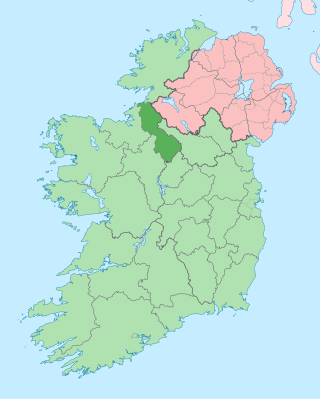
County Leitrim is a county in Ireland. It is in the province of Connacht and is part of the Northern and Western Region. It is named after the village of Leitrim. Leitrim County Council is the local authority for the county, which had a population of 35,199 according to the 2022 census.

<span class="mw-page-title-main">Carrick-on-Shannon</span> Town in County Leitrim, Ireland

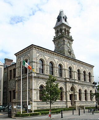
Carrick-on-Shannon is the county town of County Leitrim in Ireland. It is the largest town in the county of Leitrim. A smaller part of the town lies in County Roscommon. As of the 2022 census, the population of the town was 4,743. It is situated on a strategic crossing point of the River Shannon. The Leitrim part of the town is in the civil parish of Kiltoghert which is in the ancient barony of Leitrim.

<span class="mw-page-title-main">Sligo</span> Town in Connacht, Ireland

Sligo is a coastal seaport and the county town of County Sligo, Ireland, within the western province of Connacht. With a population of 20,608 in 2022, it is the county's largest urban centre and the 24th largest in the Republic of Ireland.

<span class="mw-page-title-main">Askeaton</span> Town in County Limerick, Ireland

Askeaton is a town in County Limerick, Ireland. The town is built on the banks of the River Deel which flows into the Shannon Estuary 3 km to the north. Askeaton is on the N69 road between Limerick and Tralee; it is 25 km west of Limerick and 8 km north of Rathkeale. The town is in a townland and civil parish of the same name.

<span class="mw-page-title-main">Ballinamore</span> Town in County Leitrim, Ireland

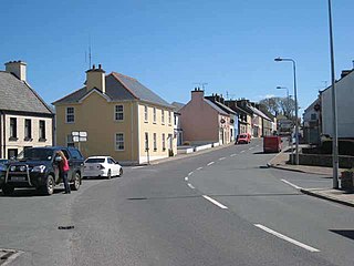
Ballinamore is a small town in the south-east of County Leitrim in Ireland.

<span class="mw-page-title-main">Manorhamilton</span> Town in County Leitrim, Ireland

Manorhamilton is the second-largest town in County Leitrim, Ireland. It is located on the N16 26 kilometres (16 mi) from Sligo and 41 kilometres (25 mi) from Enniskillen.

<span class="mw-page-title-main">Buttevant</span> Town in County Cork, Ireland

Buttevant is a medieval market town in County Cork, Ireland.

<span class="mw-page-title-main">Dromod</span> Village in County Leitrim, Ireland

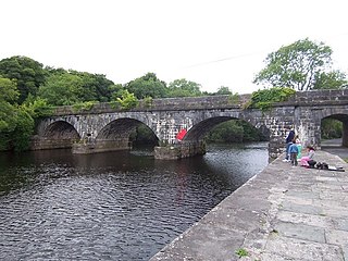
Dromod is a village in County Leitrim, Ireland. Dromod is a noted fishing village beside Bofin and Boderg, which are threaded by the River Shannon. Built along the River Shannon, this is a Tidy Towns winner with a modern harbour frequented by cruiser traffic. The Bog Oak water feature in the centre of the village, entitled 'The Weeping Tree', and was made by a local craftsman from a piece of bog oak which was found nearby.

<span class="mw-page-title-main">Drumshanbo</span> Town in County Leitrim, Ireland

Drumshanbo is a small town situated in the heart of County Leitrim, Ireland. Drumshanbo is surrounded by a scenic area of soft rolling hills, woodlands, lakes and the Sliabh an Iarainn and Arigna mountains. It is a well preserved town with traditional pubs, shops, and restaurants.

<span class="mw-page-title-main">Mohill</span> Town in County Leitrim, Connacht, Ireland

Mohill is a town in County Leitrim, Ireland. The town of Carrick-on-Shannon is approximately 16 km (10 miles) away.

<span class="mw-page-title-main">Dromahair</span> Village in County Leitrim, Ireland

Dromahair is a village in County Leitrim, Ireland. Dromahair is 10 km (6 mi) from Manorhamilton and 17 km (10 mi) from Sligo town.

<span class="mw-page-title-main">Drumkeeran</span> Village in County Leitrim, Ireland

Drumkeeran, also Drumkeerin, is a village and townland in County Leitrim, Ireland, located at the junction of the R280 and R200 roads. It is situated in drumlin hills at the foot of Corry Mountain, just north of Lough Allen.

<span class="mw-page-title-main">Drumsna</span> Village in County Leitrim, Ireland

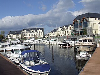
Drumsna is a village in County Leitrim, Ireland. It is situated 6 km east of Carrick-on-Shannon on the River Shannon and is located off the N4 National primary route which links Dublin and Sligo. The harbour dates to 1817 and was a hive of commercial waterway activity until the more northern navigation canal to Carrick-on-Shannon was opened in 1850. Today, the waterway is busy with anglers and tourist pursuits in the summer months.

<span class="mw-page-title-main">Leitrim, County Leitrim</span> Village in County Leitrim, Ireland

Leitrim is a village in County Leitrim, Ireland, on the River Shannon near the border with County Roscommon. It is at the junction of the R280 and R284 regional roads.

<span class="mw-page-title-main">Regional road (Ireland)</span> Class of road in Ireland

A regional road in the Republic of Ireland is a class of road not forming a major route, but nevertheless forming a link in the national route network. There are over 11,600 kilometres of regional roads. Regional roads are numbered with three-digit route numbers, prefixed by "R". The equivalent road category in Northern Ireland are B roads.

<span class="mw-page-title-main">Blacklion</span> Village in County Cavan, Ireland

Blacklion is a border village in west County Cavan, Ireland. It is situated on the N16 national primary road, just across the border from the County Fermanagh village of Belcoo.

<span class="mw-page-title-main">Parke's Castle</span> Building in County Leitrim, Ireland

Parke's Castle is a 17th century semi-fortified manor house. It is situated on the north-eastern shore of Lough Gill, in the north of County Leitrim, in the northwest of Ireland. The castle is built on the site of an earlier 16th Century O'Rourke Gaelic tower house. The castle and bawn had come into the possession of Captain Robert Parke by 1628, possibly earlier. He had been granted some of the former O'Rourke lands as part of the Plantations. By 1635, Parke had completed his fortified manor house on the site of the older Gaelic castle.

<span class="mw-page-title-main">Knockvicar</span> Village in Connacht, Ireland

Knockvicar is a village in County Roscommon, Ireland. It is located on the R285 regional road, between Boyle and Carrick-on-Shannon near Lough Key Forest Park in the north of the county.

<span class="mw-page-title-main">Maigh Nissi</span> Barony in County Leitrim, Ireland

The barony of Leitrim is a barony in County Leitrim, Ireland.

References

Notes

  1. "Baile Shéamais". logainm.ie. Archived from the original on 27 January 2020. Retrieved 26 January 2020.
  2. "Jamestown, Jamestown, Leitrim". National Inventory of Architectural Heritage. Archived from the original on 21 September 2013. Retrieved 1 April 2013 via buildingsofireland.ie.
  3. Burke 1914, pp. 173.
  4. Longman 1819, pp. 405.
  5. Watsons 1830.
  6. Irish Free State 1925, pp. 31.
  7. "The doon of Drumsna" Archaeology Ireland

Sources