Crossings
| Status | Criteria |
|---|---|
| NIAH | Rated as a structure of National heritage by the National Inventory of Architectural Heritage |
| NIAH (Regional) | Rated as a structure of Regional heritage by the National Inventory of Architectural Heritage |
| RPS | Listed on the Record of Protected Structures of the named city or county council |
| Crossing | Date | Coordinates | Heritage status | Locality | Notes | Image |
|---|---|---|---|---|---|---|
| The source of the River Shannon | 54°14′05″N7°55′08″W / 54.23475°N 7.919°W | - | Shannon Pot | Included for completeness |  | |
| Bradán Feasa footbridge [1] [2] [3] [4] | 54°14′05″N7°55′10″W / 54.2346°N 7.9195°W | - | Shannon Pot, County Cavan | Footbridge, built by the OPW, which crosses the infant Shannon about 20 meters downstream from the Shannon Pot |  | |
| Dowra bridge | 1862 [5] | 54°11′23″N8°00′51″W / 54.1896°N 8.0141°W | NIAH (Regional) [6] | Dowra, County Cavan | Last crossing above Lough Allen. Carries the R200 between Counties Cavan and Leitrim. |  |
| Bellintra bridge [7] | 54°03′40″N8°03′35″W / 54.0610°N 8.0598°W | - | Derrynadooey, County Roscommon [7] | First crossing below Lough Allen. Carries a local road (L33783 off the R280) between Counties Roscommon and Leitrim. Above sluice gates operated by the ESB Group. [7] | 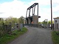 | |
| R280 bridge | 54°03′18″N8°04′05″W / 54.0549°N 8.0680°W | - | Aghafin, County Roscommon/Mahanagh, County Leitrim | Carries the R280 between Counties Roscommon and Leitrim. | ||
| Battlebridge | 53°59′47″N8°04′43″W / 53.9964°N 8.0786°W | - | Battlebridge, County Roscommon/Drumhierny, County Leitrim | Carries the R284 between Counties Roscommon and Leitrim. | ||
| Hartley bridge [8] | 1915 [8] | 53°58′02″N8°05′42″W / 53.9672°N 8.095°W | - | Cleaheen County Roscommon, 6 km west of Cootehall/County Roscommon, 3 km north of Carrick on Shannon, County Leitrim | Carries a minor road between Counties Roscommon and Leitrim. Leitrim County Council has plans to replace the bridge before 2030. [9] | 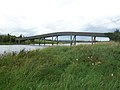 |
| Carrick Bridge [10] | 1846 [10] | 53°56′35″N8°05′45″W / 53.943°N 8.0958°W | NIAH (Regional) [11] | Carrick-on-Shannon, County Leitrim | Carries the N4 from through Carrick-on-Shannon crossing between Roscommon and Leitrim. Replaced an earlier bridge. [10] |  |
| Drumsna Railway Bridge [12] [13] | 2009 [14] [15] | 53°54′22″N7°59′34″W / 53.906°N 7.9928°W | - | Lough Tap, Border of Co. Roscommon & Leitrim | Carries the Dublin–Sligo railway line between Counties Roscommon and Leitrim over Lough Tap. Links Dromod and Carrick-on-Shannon railway stations. Replaced existing bridge dated from 1862. [14] | |
| The Jamestown Canal bypasses a non-navigable section of the River Shannon between Jamestown and Drumsna | ||||||
| X X | ||||||
| main Shannon crossings | ||||||
| Jamestown Bridge | c. 1846 [16] | 53°55′25″N8°01′47″W / 53.9235°N 8.0298°W | NIAH (Regional) [16] | East of Jamestown, County Leitrim | First of two bridges carrying the L3656 from Jamestown to Drumsna through the northern tip of County Roscommon | |
| Drumsna Bridge | 1800s | 53°55′29″N8°00′41″W / 53.9248°N 8.0113°W | NIAH (Regional) [17] | Southwest of Drumsna, County Leitrim | Second of two bridges carrying the L3656 from Jamestown to Drumsna through the northern tip of County Roscommon [17] |  |
| X X | ||||||
| Jamestown canal crossings | ||||||
| Unnamed Jamestown Canal Bridge (1) | 53°55′07″N8°01′54″W / 53.9185°N 8.0317°W | - | County Roscommon, 1 km south of Jamestown, 2 km South West of Drumsna, both in County Leitrim | Carries a minor road from the L3656 Jamestown/Drumsna Road to the L1405 Drumsna/Strokestown Road | ||
| Corry Bridge Jamestown Canal | c.1850 | 53°54′46″N8°01′06″W / 53.9127°N 8.0183°W | NIAH (Regional) [18] | Corry, Co. Roscommon | Carries the L1405 from the L3656 Jamestown/Drumsna Road towards Strokestown | 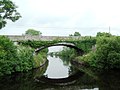 |
| The Jamestown canal rejoins the Shannon at Lough Nanoge | ||||||
| Roosky Bridge | 1840-1850 | 53°49′57″N7°55′07″W / 53.8326°N 7.9187°W | NIAH (Regional) [19] | Roosky, Co. Roscommon | Carries the R371 between Counties Roscommon and Leitrim through Roosky. |  |
| Tarmonbarry Bridge | 53°44′32″N7°55′03″W / 53.7421°N 7.9176°W | NIAH (Regional) [20] | East of Tarmonbarry, Co. Roscommon | Carries the N5 between Counties Roscommon and Longford. | 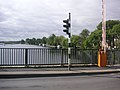 | |
| Bord na Móna rail bridge | 53°42′02″N7°59′05″W / 53.7006°N 7.9848°W | - | c.2 km North of Lough Ree Power Station, Lanesboro | Private. Narrow-gauge railway line, used to transport peat from bog to nearby power station. | ||
| Lanesboro bridge | 1835 – 1843, 1971 [21] | 53°40′27″N7°59′33″W / 53.6743°N 7.9926°W | NIAH (Regional) [21] | Lanesboro | Last crossing above Lough Ree. Links the twin towns of Lanesborough, on the County Longford (east) side and Ballyleague, on the County Roscommon (west) side of the river. |  |
| Cumann na mBan Bridge [22] [23] [24] [25] | 1991 [23] | 53°25′56″N7°57′21″W / 53.4322°N 7.9558°W | - | North of Athlone | First crossing below Lough Ree. Carries the M6/N6 Athlone bypass. Previously known as the 'Athlone Relief Road - Shannon Bridge' & 'bypass bridge', renamed in 2015, with a ceremony held in June 2017 [22] [23] [25] [24] | |
| White Bridge [26] [27] [28] | 1850 [29] | 53°25′38″N7°56′45″W / 53.4272°N 7.9459°W | NIAH [30] | Athlone | Situated c.200 m west of Athlone railway station. The Dublin–Westport/Galway railway line diverges c.200m west of the bridge |  |
| Athlone Greenway Bridge [31] | August 2023 [32] | 53°25′28″N7°56′33″W / 53.424331327303°N 7.942520174507595°W [29] | - | Luan Gallery, Athlone | Cycle/Pedestrian Bridge. Carries the Dublin-Galway Greenway from the Radisson Hotel to the Luan Gallery. [29] [33] 2022 onwards[ needs update ] [34] [29] [35] [36] In spring 2019 the tendering was projected to be completed by 2020. [37] In December 2021, it was expected to open by Easter 2023. [38] | |
| Road Bridge Athlone | 53°25′25″N7°56′31″W / 53.4237°N 7.9419°W | - | Athlone | Carries Custume Place (the R446, the old N6 Dublin - Galway Road). Links Athlone Castle and St. Peter and Paul's Church to the Eastern/Leinster side of Athlone | | |
| bridge to Long Island (West bank only) | 53°22′41″N7°55′08″W / 53.378085°N 7.9188077°W | - | Long Island, Leamore, County Roscommon | Private local road. Links Long Island to the west bank. | ||
| Shannonbridge | completed in 1757 [39] | 53°16′47″N8°03′03″W / 53.2797°N 8.0509°W | NIAH [40] | Shannonbridge, County Offaly | Carries R357 from Shannonbridge to County Roscommon | |
| Banagher bridge | 1841–1843 (widened 1971) | 53°11′36″N7°59′33″W / 53.1934°N 7.9926°W | NIAH [41] | Northwest of Banagher | Carries the R356 between Counties Offaly and Galway. |  |
| Meelick weir pedestrian bridge | 2019-2020 [42] [43] | 53°10′30″N8°04′33″W / 53.174902°N 8.075972°W [43] | - | Meelick Weir, Galway/Offaly border | Cycle/pedestrian bridge. Carries the Beara-Breifne Way near Victoria Lock over the existing weir to an island in the river. [43] At 300m, it is the longest pedestrian bridge on the island. [43] Construction, by Waterways Ireland, began in March 2019, [43] and the bridge opened in December 2020 (before being temporarily closed in January 2021 due to COVID-19 restrictions). [44] | 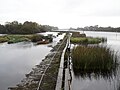 (The bridge rests on this weir.) |
| Portumna bridge | 1911 | 53°05′28″N8°11′38″W / 53.0911°N 8.1938°W | - | East of Portumna | Last crossing above Lough Derg. Carries the N65 between Counties Tipperary and Galway. Connects Lehinch island to both banks. |  |
| Killaloe Bridge | c.1770 [45] | 52°48′29″N8°26′21″W / 52.808115°N 8.439110°W | NIAH (Regional) [45] RPS Clare CC & Tipperary CC [46] [47] | Between Ballina, County Tipperary and Killaloe, County Clare | First crossing below Lough Derg. A single lane road bridge linking Counties Tipperary and Clare |  |
| Brian Boru Bridge | 2025 [48] | 52°48′00″N8°26′12″W / 52.7999147757052°N 8.436787240512189°W | - | Between Ballina, County Tipperary and Killaloe, County Clare | Opened in 2025 to ease traffic congestion in Ballina and Killaloe. [49] 1 km downstream from the aforementioned Killaloe Bridge. [48] A large modern road bridge linking Counties Tipperary and Clare | |
| The Ardnacrusha power plant headrace canal splits off from the Shannon c.4 km south of Killaloe | ||||||
| X X | ||||||
| main Shannon crossings | ||||||
| O'Briensbridge (Shannon) | 1780 - 1810 [50] | 52°45′08″N8°29′55″W / 52.7522°N 8.4985°W | NIAH (Regional) [50] | East of the village of O'Briensbridge, Co. Clare | Carries the R466 from O'Briensbridge, Co. Clare into Montpelier, County Limerick. Replaced former bridge around 1750, partially replaced in 1842, and modified to include a navigation arch in the 1920s. [51] |  |
| The Blackwater distributary river splits off to the west from the Shannon at Drumeen | ||||||
| X X | ||||||
| main Shannon crossings | ||||||
| The Living Bridge | 2007 | 52°40′36″N8°34′13″W / 52.6768°N 8.5702°W | - | University of Limerick main campus | Pedestrian bridge. Links the main campus on the south bank (in County Limerick) to student residences on the north bank (in County Clare). |  |
| University Bridge | 2004 | 52°40′41″N8°34′35″W / 52.678°N 8.5763°W | - | University of Limerick main campus | Links the main campus on the south bank (in County Limerick) to student residences on the north bank (in County Clare). |  |
| Black Bridge/ "Plassey Bridge" [52] | 1840s | 52°40′41″N8°34′48″W / 52.678088°N 8.580037°W | - | Plassey, County Limerick | Pedestrian bridge links Thomond Village, County Clare to the old mill works at Plassey, County Limerick |  |
| X X | ||||||
| Blackwater River crossings | ||||||
| Errina bridge [53] | 52°43′59″N8°32′00″W / 52.7331°N 8.5333°W | - | Errina, County Clare | Close to the Ardnacrusha canal (which is (c.100m to the north)). | ||
| bridge at Gillogue | 52°41′09″N8°34′19″W / 52.6859°N 8.572°W | - | East of Gillogue office park, County Clare | Narrow single lane stone bridge. Unmarked lane. | ||
| The Shannon and Blackwater rejoin at Thomond village | ||||||
| Parteen Railway Bridge [54] | 2010 | 52°40′53″N8°37′40″W / 52.6813°N 8.6279°W | - | Thomondgate, County Limerick | Carries the Limerick-Galway railway line. Used until 1980s for Limerick-Claremorris line. Restored in early 2008. | |
| Athlunkard Bridge | 1825 - 1830 [55] | 52°40′52″N8°36′36″W / 52.6812°N 8.6099°W | NIAH (Regional) [55] | Corbally, Co. Limerick | Carries the R463 between Corbally Road on the outskirts of Limerick city and Athlunkard Avenue in Corbally, County Clare. | |
| X X | ||||||
| Ardnacrusha headrace canal crossings | ||||||
| canal bridge, O'Briensbridge | 52°45′11″N8°30′24″W / 52.753°N 8.5068°W | - | West of the village of O'Briensbridge, Co. Clare | Carries the R466 from O'Briensbridge into Bridgetown | ||
| Ardnacrusha power plant | 1928 | 52°42′20″N8°36′44″W / 52.705594°N 8.612313°W | - | Southwest of Ardnacrusha within County Clare approximately 1.5 miles (2.4 km) from the Limerick border | ESB Group private property. It is Ireland's largest river hydroelectric scheme. |  |
| The Shannon and Ardnacrusha canal rejoin at Thomas Island | ||||||
| The Shannon splits around King's Island in Limerick City with the Abbey river being a distributary branch to the east | ||||||
| X X | ||||||
| Abbey River crossings | ||||||
| Baal's Bridge [56] [57] | 1830 - 1831 [56] | 52°39′59″N8°37′13″W / 52.6663°N 8.6202°W | NIAH (Regional) [56] | Limerick | Carries Mary Street from George's Quay on King's Island to Charlotte's Quay on the south side of Limerick city. Replaced (old) Baal's Bridge, erected in c. 16th century, demolished in 1829, and bridges have stood here since at least the 12th century. [58] [59] |  |
| Bishop O'Dwyer Bridge [60] | 1931 [60] | 52°40′10″N8°37′05″W / 52.6694°N 8.618°W | NIAH (Regional) [61] | Limerick | Carries Athlunkard Street from Sir Harry's Mall to the Grove Island Roundabout. Named in honour of Edward O'Dwyer, Bishop of Limerick. [60] Replaced Park Bridge built in 1835. [60] |  |
| Abbey Bridge [62] | 1999 [62] | 52°40′00″N8°37′09″W / 52.6666°N 8.6193°W | - | Limerick | Carries Island Road from King's Island to the Milk Market. Named in honour of generations of the fishermen of the river Abbey, after a proposal to name it after Jim Kemmy was rejected. [62] |  |
| Mathew Bridge [63] | 1844 - 1846 [63] | 52°40′01″N8°37′25″W / 52.6669°N 8.6237°W | NIAH (Regional) [63] | Limerick | Carries Bridge Street (R463) from King's Island to Rutland Street on the south side of Limerick city. |  |
| Sylvester O'Halloran Bridge [64] | 1987 [64] | 52°39′55″N8°37′26″W / 52.6653°N 8.6238°W | - | Limerick | Pedestrian Bridge from the Potato Market, King's Island to behind the Hunt Museum on the south side of Limerick city. |   |
| X X | ||||||
| Shannon River crossings at King's Island | ||||||
| Sarsfield Bridge [65] | 1835 [65] | 52°39′55″N8°37′49″W / 52.6654°N 8.6303°W | NIAH (Regional) [66] | Limerick | Swing bridge (non-functioning). [65] Originally known as the Wellesley Bridge. [65] Carries the R857 Ennis Road. The Shannon Rowing Club Boat house was based on an island under the bridge until it was damaged by Storm Darwin [65] |   |
| Thomond Bridge | 1840 [67] | 52°40′13″N8°37′38″W / 52.670304°N 8.627174°W | NIAH (Regional) [67] | Limerick | Links Castle Street on King's Island to High Road on the Northwest bank |   |
| The Shannon and Abbey rejoin below Kings Island | ||||||
| Shannon Bridge | 1986 | 52°39′44″N8°38′06″W / 52.6623°N 8.6351°W | - | Limerick | Carries the R527 between Farranshore More and Mountkennet. Last bridge in the city and over the Shannon |  |
| Limerick Tunnel [68] | 2010 | 52°39′19″N8°41′12″W / 52.6552°N 8.6868°W | - | Limerick | Carries the N18, Western part of the Limerick Southern Ring Road. [68] |  |
| Shannon Ferry | 1969 [69] | 52°36′53″N9°22′49″W / 52.6147°N 9.3804°W | - | Killimer, County Clare - Tarbert Island, County Kerry | Ro-ro ferry. Part of the N67 |  |
| Planned Crossings/Crossings Under Construction | ||||||
| Pedestrian Bridge/walkway Limerick [a] | 2022 onwards [70] | - | Cleeves factory-O'Callaghan strand Limerick City | Pedestrian Walkway or Bridge (under discussion) [70] [71] [72] [73] [74] | ||
| Pedestrian bridge, city canal, limerick [b] | 2022 onwards [75] | 52°40′05″N8°36′27″W / 52.668°N 8.6075°W [75] | - | Park canal limerick, 20 metres west of railway bridge [75] | Pedestrian bridge connecting park | |