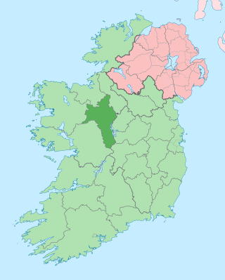
County Roscommon is a county in Ireland. It is part of the province of Connacht and the Northern and Western Region. It is the 11th largest Irish county by area and 27th most populous. Its county town and largest town is Roscommon. Roscommon County Council is the local authority for the county. The population of the county was 69,995 as of the 2022 census.

County Longford is a county in Ireland. It is in the province of Leinster. It is named after the town of Longford. Longford County Council is the local authority for the county. The population of the county was 46,634 at the 2022 census. The county is based on the historic Gaelic territory of Annaly (Anghaile), formerly known as Teffia (Teathbha).

County Cavan is a county in Ireland. It is in the province of Ulster and is part of the Northern and Western Region. It is named after the town of Cavan and is based on the historic Gaelic territory of East Breffny (Bréifne). Cavan County Council is the local authority for the county, which had a population of 81,704 at the 2022 census.

Carrigaline is a town and civil parish in County Cork, Ireland, situated on the River Owenabue. Located about 12 kilometres (7.5 mi) south of Cork city, and with a population of 18,239 people, it is one of the largest commuter towns in the county. The R611 regional road passes through the town, and it is just off the N28 national primary route to Ringaskiddy. Carrigaline grew rapidly in the late 20th century, from a village of a few hundred people into a thriving commuter town although some locals still refer to it as "the village". The town is one of the key gateways to west Cork, especially for those who arrive by ferry from France. Carrigaline is within the Cork South-Central Dáil constituency.

Longford is the county town of County Longford in Ireland. It had a population of 10,952 at the 2022 census. It is the biggest town in the county and about one third of the county's population lives there. Longford lies at the meeting of Ireland's N4 and N5 National Primary Route roads, which means that traffic travelling between Dublin and County Mayo, or north County Roscommon passes around the town. Longford railway station, on the Dublin-Sligo line, is used heavily by commuters.

Edgeworthstown or Mostrim is a small town in County Longford, Ireland. The town is in the east of the county, near the border with County Westmeath. Nearby towns are Longford 12 km to the west, Mullingar 26 km to the east, Athlone 40 km to the south and Cavan 42 km to the north. The N4 and N55 roads meet in the town. The town is in the townland of Edgeworthstown and in the civil parish of Mostrim.

Granard is a town in the north of County Longford, Ireland, and has a traceable history going back to 236 CE. It is situated just south of the boundary between the watersheds of the Shannon and the Erne, at the point where the N55 national secondary road and the R194 regional road meet. It is 20 km north-east of Longford town. The barony of Granard is named for the town. The town is also in the civil parish of Granard.

Ballaghaderreen is a town in County Roscommon, Ireland. It was part of County Mayo prior to 1898. It is in the north-west of the county, near the borders with counties Mayo and Sligo, just off the N5 road. The population was 1,808 in the 2016 census.

Ferbane is a town in County Offaly, Ireland. It is on the north bank of the River Brosna, between Birr and Athlone at the junction of the N62 and R436 roads, 20 km south of Athlone. The name of the town is said to come from the white bog cotton which grows in the surrounding Bog of Allen.

Carrickmore is a small town in County Tyrone, Northern Ireland. It is situated in the historic barony of Omagh East, the civil parish of Termonmaguirk and the Roman Catholic Parish of Termonmaguirc between Cookstown, Dungannon and Omagh. It had a population of 612 in the 2001 Census. In the 2011 Census 2,330 people lived in the Termon Ward, which covers the Carrickmore and Creggan areas.
Ballinalee, sometimes known as Saint Johnstown, is a village in north County Longford, Ireland. It is situated on the River Camlin, and falls within the civil parish of Clonbroney. As of the 2016 census, the village had a population of 347 people.

Termonfeckin or Termonfechin is a small village and townland in County Louth, Ireland. It is within the parish of the same name, and lies repeatedly 8 km (5.0 mi) north-east of Drogheda. The population of the village almost quadrupled in the period between the 1996 and 2022 census, growing from 530 to 1,983 inhabitants.

Enfield, also known as Innfield, is a town in south County Meath, Ireland, situated between Kilcock and Kinnegad and very close to the border with County Kildare. The town is on the Dublin-Sligo railway line. It is located on the R148 regional road, formerly the N4 national primary road connecting Dublin to Connacht.

Arvagh, or Arva, is a village in County Cavan, Ireland, on the shores of Garty Lough and overlooked by Bruse Mountain. It is located on the junction of the R198 and R203 regional roads.
Saint Berach of Termonbarry was a celebrated Irish saint, whose memory is still celebrated in County Roscommon. He was a disciple of Saint Kevin.

Lanesborough–Ballyleague, more commonly known simply as Lanesborough, is a town in the midlands of Ireland. Lanesborough is on the County Longford (east) side and Ballyleague on the County Roscommon (west) side of the River Shannon, at the northern tip of Lough Ree.

Cloondara is a small village in County Longford, Ireland. It is situated just off the N5 road near Termonbarry, where the Royal Canal terminates at the River Shannon. It lies 7 km (4.3 mi) west of Longford Town. The Royal Canal is being upgraded so that canal boats can once again travel along it. The village of Termonbarry lies to the west of the village, on the opposite bank of the River Shannon. Many residential properties are being built, due to the tax incentives available in the area.
Drumlish is a village in County Longford, Ireland. It lies on the R198 regional road 10 km (6.2 mi) north of Longford Town, close to the border with County Leitrim.

Newtown Forbes is a large village in County Longford, Ireland. It was historically called Lisbrack, an anglicisation of the Irish name.
Termonn is a Gaelic (Irish) word meaning 'sanctuary, boundary'. Other spellings include tearmann,tarman and termondd. It denotes land belonging to Irish early Christian monasteries and churches on which right of sanctuary prevailed. The word is common in many place names in Ireland.


