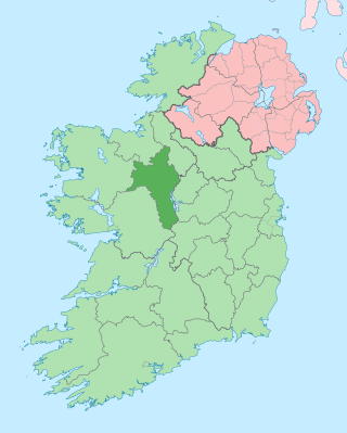
County Roscommon is a county in Ireland. It is part of the province of Connacht and the Northern and Western Region. It is the 11th largest Irish county by area and 27th most populous. Its county town and largest town is Roscommon. Roscommon County Council is the local authority for the county. The population of the county was 69,995 as of the 2022 census.
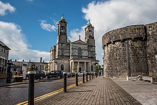
Athlone is a town on the border of County Roscommon and County Westmeath, Ireland. It is located on the River Shannon near the southern shore of Lough Ree. It is the second most populous town in the Midlands Region with a population of 21,349 in the 2016 census.

County Longford is a county in Ireland. It is in the province of Leinster. It is named after the town of Longford. Longford County Council is the local authority for the county. The population of the county was 46,634 at the 2022 census. The county is based on the historic Gaelic territory of Annaly (Anghaile), formerly known as Teffia (Teathbha).
County Westmeath is a county in Ireland. It is in the province of Leinster and is part of the Eastern and Midland Region. It formed part of the historic Kingdom of Meath, which was named Mide because the kingdom was located in the geographical centre of Ireland. Westmeath County Council is the administrative body for the county, and the county town is Mullingar. At the 2022 census, the population of the county was 95,840.

Carrick-on-Shannon is the county town of County Leitrim in Ireland. It is the largest town in the county of Leitrim. A smaller part of the town lies in County Roscommon. The population of the town was 4,062 in 2016. It is situated on a strategic crossing point of the River Shannon. The Leitrim part of the town is in the civil parish of Kiltoghert which is in the ancient barony of Leitrim.

Lough Ree is a lake in the midlands of Ireland, the second of the three major lakes on the River Shannon. Lough Ree is the second largest lake on the Shannon after Lough Derg. The other two major lakes are Lough Allen to the north, and Lough Derg to the south. There are also several minor lakes along the length of the river. The lake serves as a border between the counties of Longford and Westmeath on the eastern side and County Roscommon in the province of Connacht on the western side. The lake is popular for fishing and boating. The lake supports a small commercial eel fishery and is locally famous for its eels on wheels truck. The town of Athlone is situated at the southern end of the lake, and has a harbour for boats going out on the lake. The small town of Lanesboro is at the northern end of the lake.

Coosan is a townland and suburb just north of Athlone, County Westmeath in Ireland. The suburb is surrounded on three sides by Lough Ree and on one side by Athlone.
Knockcroghery is a village and townland in County Roscommon, Ireland. It is located on the N61 road between Athlone and Roscommon town, near Lough Ree on the River Shannon. The townland of Knockcroghery is in the civil parish of Killinvoy and the historical barony of Athlone North.
Mullinalaghta, also officially referred to as Mullanalaghta, is a half-parish in the north-eastern part of County Longford, Ireland, located about eight kilometres north of Granard.

The Diocese of Elphin is a Roman Catholic diocese in the western part of Ireland. It is in the Metropolitan Province of Tuam and is subject to the Metropolitan Archdiocese of Tuam. The current bishop is Kevin Doran who was appointed in 2014.
Newtowncashel is a village located near Lough Ree in County Longford, Ireland. It is within the townland of Cornadowagh. Newtowncashel won the Irish Tidy Towns Competition in 1980.

Tubberclare or Tubberclair is a village and townland in County Westmeath, Ireland, between Ballymahon and Athlone. It lies 9 km (6 mi) from Athlone, on the N55 national secondary road, and 2 km (1 mi) north of Glasson. Toberclare is the official spelling of the name in English.

Carnacon or Carrownacon is a village, townland and area in central County Mayo, Ireland. It is situated about 12 miles (19 km) from Castlebar, and is about 8 miles (13 km) from Claremorris and Ballinrobe.

Kilkenny West, previously Maherquirke or Dillons country, is a barony in west County Westmeath, Ireland. It was formed by 1542. It is bordered by County Longford to the west; it is also bordered by three other Westmeath baronies: Rathconrath, Brawny and Clonlonan. The largest centre of population in the barony is the village of Glassan.
Brawny is a barony in south–west County Westmeath, Ireland. It was formed by 1672. It is bordered by County Roscommon to the west. It also borders two other Westmeath baronies: Kilkenny West and Clonlonan. The largest centre of population in the barony is the town of Athlone.
Éamann Ó hOrchaidh was an Irish scribe and translator.
Clonagh is a townland in County Westmeath, Ireland. The townland is in the civil parish of St. Mary's.
Aughnasurn, or Aghnasurn is a townland in the civil parish of Kilbryan, County Roscommon, Ireland.

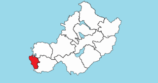
Athlone South, also called South Athlone, is a barony in County Roscommon, Republic of Ireland. Baronies were mainly cadastral rather than administrative units. They acquired modest local taxation and spending functions in the 19th century before being superseded by the Local Government (Ireland) Act 1898.
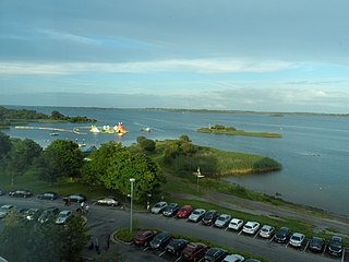
Baysports is an outdoor watersports centre located on the outskirts of Athlone at Hodson Bay on the west shore of Lough Ree. It is home to Ireland's largest inflatable water park and adjoins the Hodson Bay Hotel. Opened in June 2009, it holds the Guinness World Record for the tallest floating waterslide in the world.

