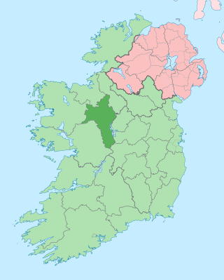
County Roscommon is a county in Ireland. It is part of the province of Connacht and the Northern and Western Region. It is the 11th largest Irish county by area and 27th most populous. Its county town and largest town is Roscommon. Roscommon County Council is the local authority for the county. The population of the county was 69,995 as of the 2022 census.
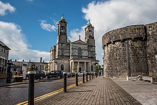
Athlone is a town on the border of County Roscommon and County Westmeath, Ireland. It is located on the River Shannon near the southern shore of Lough Ree. It is the second most populous town in the Midlands Region with a population of 21,349 in the 2016 census.
County Westmeath is a county in Ireland. It is in the province of Leinster and is part of the Eastern and Midland Region. It formed part of the historic Kingdom of Meath, which was named Mide because the kingdom was located in the geographical centre of Ireland. Westmeath County Council is the administrative body for the county, and the county town is Mullingar. At the 2022 census, the population of the county was 95,840.

Ballymahon on the River Inny is a town in the southern part of County Longford, Ireland. It is located at the junction of the N55 National secondary road and the R392 regional road.

The N6 road is a national primary road in Ireland from junction 11 on the M4 motorway at Kinnegad to Galway city. The N6 and N4 form a continuous motorway or dual carriageway from Dublin city centre to Galway City passing in an east–west direction through the midlands of Ireland. Most of the road is motorway standard with the exception of the Athlone bypass and stretches of urban road in Galway City, which are the only sections of the road that remain designated as N6 dual carriageway. There is one toll on the road outside Galway city. Major upgrades to the road were completed in December 2009 completing the first intercity motorway/dual carriageway in Ireland and the New Junctions of M6 are built and will be 164 km.
Knockcroghery is a village and townland in County Roscommon, Ireland. It is located on the N61 road between Athlone and Roscommon town, near Lough Ree on the River Shannon. The townland of Knockcroghery is in the civil parish of Killinvoy and the historical barony of Athlone North.
Athlone was a parliamentary constituency in Ireland, which from 1801 to 1885 returned one Member of Parliament (MP) to the House of Commons of the United Kingdom of Great Britain and Ireland.
Dysart is a village in County Roscommon, Ireland. It lies 20 km (12 mi) from the centre of Athlone, on the R363 regional road. Located at the crossroads of the R363 and the R357, the village was formerly known as 'Thomas Street'.

The Diocese of Elphin is a Roman Catholic diocese in the western part of Ireland. It is in the Metropolitan Province of Tuam and is subject to the Metropolitan Archdiocese of Tuam. The current bishop is Kevin Doran who was appointed in 2014.

Taghmaconnell or Taughmaconnell is a small village in County Roscommon, Ireland. It lies between Athlone and Ballinasloe. It is also the name of the parish in which the village lies.

The R446 road is a regional road in Ireland. The road connects Kinnegad in County Westmeath to Galway City. Prior to the construction of the M6 motorway the R446 formed the main N6 road connecting Dublin and Galway. Following the opening of the M6; the old N6 road was downgraded to regional road status and was designated as the R446. The road is an alternative route between Galway and Dublin and runs in parallel to the M6.

The N61 road is a national secondary road in County Roscommon in Ireland, linking Athlone, Roscommon, Tulsk, and Boyle. It also connects the N6, N63, N60, N5, and N4 national primary and national secondary roads, as well as seven regional roads. The road is 74.193 kilometres (46.101 mi) long.
Bellanamullia or Bealnamulla is a village in County Roscommon, Ireland. It lies 4 km (2.5 mi) from the centre of Athlone, just beyond the urban boundary, on the R362 regional road.

Drum is a civil parish in south County Roscommon about 5 km west of Athlone. It lies in the barony of Athlone. One of the townlands in the parish is also called Drum. Meehambee Dolmen, a portal tomb estimated to be 5,500 years old, is located in the northern part of the parish. In the village there are a number of historical and religious sites, including Drum Cemetery, St. Brigid's Church and Drum Monastic Site. Drum Parish Hall and Drum Heritage Visitor Centre are located next to the graveyard, in the townland of Belrea.

Brideswell is a village located in the south of County Roscommon, Ireland. It lies 11km from the Centre of Athlone and 60km from Tuam Town.

The Lecarrow Canal is a 1.5-kilometre (0.93 mi) navigable canal in County Roscommon, Ireland, connecting the village of Lecarrow to Lough Ree. Constructed in the 1840s to carry limestone from a quarry to Athlone for construction projects by the Shannon Commissioners, it first fell into disuse after 17 years but was cleaned up in 1889 and was dredged in the 1960s by the Office of Public Works.
Brawny is a barony in south–west County Westmeath, Ireland. It was formed by 1672. It is bordered by County Roscommon to the west. It also borders two other Westmeath baronies: Kilkenny West and Clonlonan. The largest centre of population in the barony is the town of Athlone.

Clonlonan is a barony in south–west County Westmeath, Ireland. It was formed by 1672. It is bordered by County Offaly to the south and a small part of County Roscommon at Long Island on the River Shannon to the west. It also borders four other Westmeath baronies: Kilkenny West and Rathconrath, Moycashel and Brawny. The largest centre of population in the barony is the town of Moate.

Rindoon is an abandoned village located in County Roscommon, Ireland.
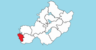
Athlone South, also called South Athlone, is a barony in County Roscommon, Ireland. Baronies were mainly cadastral rather than administrative units. They acquired modest local taxation and spending functions in the 19th century before being superseded by the Local Government (Ireland) Act 1898.


