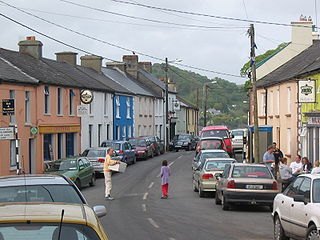
Union Hall, also Unionhall, is a small fishing village located in County Cork, Ireland, located on the west side of Glandore Harbour. Its nearest neighbour to the west is Castletownshend; to the east, Glandore village. It is approximately 10 kilometres south-east of Skibbereen. As of the 2016 census, 270 people were living in Union Hall.

Rosscarbery is a village and census town in County Cork, Ireland. The village is on a shallow estuary, which opens onto Rosscarbery Bay. Rosscarbery is in the Cork South-West constituency, which has three seats.

Coolock is a large suburban area, centred on a village, on Dublin city's Northside in Ireland. Coolock is crossed by the Santry River, a prominent feature in the middle of the district, with a linear park and ponds. The Coolock suburban area encompasses parts of three Dublin postal districts: Dublin 5, Dublin 13 and Dublin 17.

Clontibret is a village and parish in County Monaghan, Ireland. The village population in the 2016 census was 172. Clontibret is also a parish in both Roman Catholic and Church of Ireland traditions. The territory of the parish also includes Annyalla and Doohamlet as well as smaller settlements such as Cremartin, Scotch Corner and Lisnagrieve.

Dál nAraidi or Dál Araide, sometimes Latinised as Dalaradia or Anglicised as Dalaray, was a Cruthin kingdom, or possibly a confederation of Cruthin tribes, in north-eastern Ireland during the Middle Ages. It was part of the over-kingdom of Ulaid, and its kings often contended with the Dál Fiatach for the over-kingship of the province. At its greatest extent, the borders of Dál nAraidi roughly matched those of County Antrim, and they seemed to occupy the same area as the earlier Robogdii of Ptolemy's Geography, a region shared with Dál Riata. Their capital was Ráth Mór outside Antrim, and their eponymous ancestor is claimed as being Fiachu Araide.

Clonaslee is a village in north County Laois, Ireland, situated in the foothills of the Slieve Bloom Mountains on the R422 Mountmellick to Birr road. Clonaslee is approximately 100 km west of Dublin, and is close to the towns of Portlaoise and Tullamore.
Clonoulty is a small village and a civil parish in County Tipperary, Ireland. It is one of nine civil parishes in the barony of Kilnamanagh Lower. It is also one half of the ecclesiastical parish of Clonoulty-Rossmore in the Roman Catholic Archdiocese of Cashel and Emly. Clonoulty may also refer to a slightly larger area which forms one half of the catchment area for Clonoulty-Rossmore GAA club.
Clonee is a village and a townland in County Meath, Ireland. It borders Fingal to the east at the townlands of Huntstown and Littlepace, and is sometimes used in addresses for housing in those townlands. The River Tolka passes the village.

Emly or Emlybeg is a village in County Tipperary, Ireland. It is a civil parish in the historical barony of Clanwilliam. It is also an Ecclesiastical parish in the Roman Catholic Archdiocese of Cashel and Emly.

Cloonfad is a village in County Roscommon, Ireland, at the crossroads of the N83 National secondary road and the R327 regional road, about 10 km from the town of Ballyhaunis in County Mayo. A public walkway takes walkers to neighbouring villages through surrounding moorland. This habitat gave rise to the village's name in Irish - Cluain Fada or "Long Meadow". Cloonfad's local church, the Church of Saint Patrick, has been publishing an annual parish magazine since 1992 "The Cloonfad Magazine".
Clonygowan is a village in County Offaly, Ireland, on the R420 regional road between Tullamore to Portarlington road. As of the 2016 census, it had a population of 198 people. The main village centre is built around a central green.

Clondrohid is a village and civil parish in County Cork, Ireland, four miles (6 km) north of Macroom. As of the 2016 census, the population of the village was recorded as 179, down from 188 people as of the 2011 census.
Knockaderry is a village in County Limerick, Ireland. The population of the Knockaderry electoral division is approximately 500 people.
Faithleach of Clontuskert, Irish saint, fl. 600.
Anne McLoughlin, Irish aid worker and hostage, born c. 1960.
Clonlara, officially Cloonlara, is a village in County Clare, Ireland, and a Roman Catholic parish of the same name.
Cloncollow is a townland in the Parish of Tomregan, Barony of Loughtee Lower, County Cavan, Ireland.

Clonmoyle East is a townland within both the civil parish and catholic parish of Aghabullogue, County Cork, Ireland. It is 756.05 acres in size, situate east of Aghabullogue village, and north of Coachford village.

Clontead Beg is a townland within the civil parish of Magourney and Catholic parish of Aghabullogue, County Cork, Ireland. It is approximately 229 acres in size, and east of Coachford village.

Clongeen is a village and civil parish in County Wexford, Ireland. The village is about 2 kilometres (1.2 mi) south of Foulkesmill. The population was 267 at the 2016 census. The village's Catholic church, St Aidan's, was completed in 1839. Clongeen GAA Club competes in football and camogie.


