
The River Shannon, at 360.5 km in length, is the longest river in the British Isles It drains the Shannon River Basin, which has an area of 16,865 km2 (6,512 sq mi), - one fifth of the area of the island.
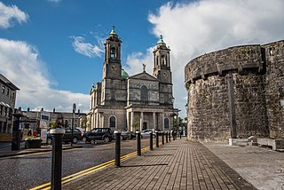
Athlone is a town on the border of County Roscommon and County Westmeath, Ireland. It is located on the River Shannon near the southern shore of Lough Ree. It is the second most populous town in the Midlands Region with a population of 21,349 in the 2016 census.

County Offaly is a county in Ireland. It is part of the Eastern and Midland Region and the province of Leinster. It is named after the ancient Kingdom of Uí Failghe. It was formerly known as King's County, in honour of Philip II of Spain. Offaly County Council is the local authority for the county. The county population was 77,961 at the 2016 census.

Killaloe is a large village in east County Clare, Ireland. The village lies on the River Shannon on the western bank of Lough Derg and is connected by Killaloe Bridge to the "twin town" of Ballina on the eastern bank of the lake.

Lough Derg, historically Lough Dergart, is a freshwater lake in the Shannon River Basin, Ireland. It is the third-biggest on the island of Ireland.

Portumna is a market town in the south-east of County Galway, Ireland, on the border with and linked by a bridge to County Tipperary. The town is located to the west of the point where the River Shannon enters Lough Derg. This historic crossing point over the River Shannon between counties Tipperary and Galway has a long history of bridges and ferry crossings. On the south-western edge of the town lie Portumna Castle and Portumna forest park.

Cloughjordan, officially Cloghjordan, is a town in County Tipperary in Ireland. It is in the barony of Ormond Lower, and it is also a parish in the Roman Catholic Diocese of Killaloe.

The N65 road is a national secondary road in Ireland. It links the N52 at Borrisokane, County Tipperary to the M6 north of Loughrea in County Galway.
Lorrha is a small village at the northern tip of County Tipperary, Ireland. It is located on a minor road between the R489 Birr to Portumna road and the N65 Nenagh to Portumna road about five kilometres east of the point where the River Shannon enters Lough Derg.
Rathcabbin often Rathcabban is a small village and an electoral district situated at the very north of County Tipperary in Ireland. The village is located off the R489 regional road between Portumna, County Galway and Birr, County Offaly. It is 5 km east of the River Shannon and Lough Derg.
Portland is a townland in the barony of Ormond Lower, County Tipperary in Ireland. It is located north-east of the Portumna bridge, in the civil parish of Lorrha.

The Little Brosna River rises near Dunkerrin, County Offaly, Ireland. It flows for 36 miles before joining the River Shannon.
The Ballyfinboy River rises close to Moneygall in County Offaly, Ireland and flows in a generally northwesterly direction into Lough Derg at Drominagh. It forms part of the boundary between County Tipperary and County Offaly. The river flows through the towns of Cloughjordan and Borrisokane west of which it flows past Ballyfinboy Castle, a ruined tower house with a Sheela na gig in the townland of Ballyfinboy.
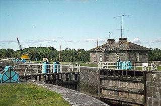
Victoria Lock, also known as Meelick Lock, is the first lock on the River Shannon upstream of Lough Derg, it is situated between Meelick, County Galway and Clonahenoge, County Offaly where the Little Brosna River enters the Shannon. It is very near the tripoint where the provinces of Munster, Leinster and Connacht meet. The lock is of architectural and technical interest and is listed on the Nation Inventory of Architectural Heritage, the dimensions are 142 ft x 40 ft. Thomas Rhodes on the instructions of the Shannon Commissioners constructed the lock in the 1840s as part of a widescale upgrade of the Shannon Navigation. The lock is still in use today by pleasure craft, both private and fleets of rental cruisers who use the River Shannon and the connecting canals. A second lock, Hamilton Lock is also located nearby but is now disused.
Albert Lock, is a lock on the Jamestown Canal which by-passes an unnavigable section of the River Shannon between Drumsna and Jamestown in Ireland. The canal and lock are located in County Roscommon. The lock dimensions are 102 ft x 30 ft. The Shannon Commissioners constructed the lock in the 1848 as part of a widescale upgrade of the Shannon Navigation.

The Nenagh River rises in the Silvermine Mountains in County Tipperary, Ireland. It flows east of Nenagh and into Lough Derg just north of Dromineer.
Redwood is a townland in the historical Barony of Ormond Lower, County Tipperary, Ireland. It is also an electoral district in the Dáil constituency of Offaly having previously been part of the Tipperary North Dáil constituency.

The Jamestown Canal bypasses a non-navigable section of the River Shannon between Jamestown and Drumsna in Ireland. The canal is 2.6 km in length and is located in County Roscommon. The Shannon Commissioners constructed the canal in 1848 to replace an earlier, smaller canal as part of a widescale upgrade of the Shannon Navigation.

Killaloe Bridge is a road bridge over the River Shannon between Ballina in County Tipperary and Killaloe, County Clare in Ireland. Built on the site of an earlier structure, the eighteenth-century bridge has thirteen arches and includes a lifting section that was added in 1929. The bridge has only one vehicular lane, with traffic lights to control vehicle movement. The bridge is a protected structure, listed on the Record of Protected Structures by both Clare County Council (#210) and Tipperary County Council (#S672).

