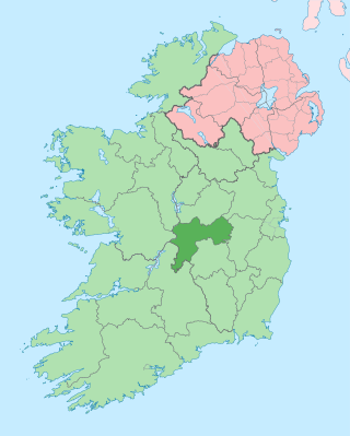
County Offaly is a county in Ireland. It is part of the Eastern and Midland Region and the province of Leinster. It is named after the ancient Kingdom of Uí Failghe. It was formerly known as King's County, in honour of Philip II of Spain. Offaly County Council is the local authority for the county. The county population was 82,668 at the 2022 census.

Banagher is a town in Ireland, located in the midlands, on the western edge of County Offaly in the province of Leinster, on the banks of the River Shannon. The town had a population of 3,000 at the height of its economic growth in the mid-19th century. According to the most recent census data of 2022, the population was just over 1,900.

Clarecastle is a village just south of Ennis in County Clare, Ireland. From 2008 to 2016 the village saw a significant population increase due to its proximity to Ennis, Shannon, and Limerick.

As with other cities in Ireland, Limerick has a history of great architecture. A 1574 document prepared for the Spanish ambassador attests to its wealth and fine architecture:

Eyrecourt, historically known as Donanaghta, is a village in County Galway, Ireland. Eyrecourt is on the R356 regional road 12 km west of the Banagher bridge over the River Shannon.

Portumna is a market town in the south-east of County Galway, Ireland, on the border with and linked by a bridge to County Tipperary. The town is located to the west of the point where the River Shannon enters Lough Derg. This historic crossing point over the River Shannon between counties Tipperary and Galway has a long history of bridges and ferry crossings. On the south-western edge of the town lie Portumna Castle and Portumna forest park.

A regional road in the Republic of Ireland is a class of road not forming a major route, but nevertheless forming a link in the national route network. There are over 11,600 kilometres of regional roads. Regional roads are numbered with three-digit route numbers, prefixed by "R". The equivalent road category in Northern Ireland are B roads.
Lusmagh is a civil parish in County Offaly, Ireland, bounded by three rivers: the Shannon, Lusmagh and Little Brosna to the west, east and south respectively. The town of Banagher is northeast across the River Lusmagh. Lusmagh was considered part of County Galway in 1628 and Connacht until 1373; the Lusmagh Roman Catholic parish is the only one in the Diocese of Clonfert east of the Shannon. According to the history of the O'Kellys of Hy-Many, Lusmhaigh means the plain of the healing herbs. In Christian times, the parish was named Cill Mochonna, "the Church of Mo Chua". Saint Mo Chua of Balla, also called Crónán, founded a monastery in 600 on the site of Cloghan Castle. The name Lusmagh was restored to the Catholic parish around 1810. Its parish church, named after St. Crónán, is about three miles southwest of Banagher.

Athlone was besieged twice during the Williamite War in Ireland (1689–91). The town is situated in the centre of Ireland on the River Shannon and commanded the bridge crossing the river into the Jacobite-held province of Connacht. For this reason, it was of key strategic importance.
Meelick, also Milic, is a townland on the River Shannon in Ireland. It lies approximately 4 km southeast of Eyrecourt in County Galway.It is best known for its walkway that connects to Lusmagh (Offaly). It also holds the oldest church still in use in Ireland at 608 years old given papal permission and built in 1414 AD it is also within the Parish of Clonfert which is home to the madonna statue Our Lady of Clonfert. Clonfert is the head of its diocese with its headquarters home to Most Rev. Bishop Michael Duignan, St. Brendans Presbytery Loughrea. It is home to the oldest hurling club in Ireland which was founded in 1884. It has a little pub 10 yards from The Church known locally as “George’s/The Shop” It holds a kayaking festival each year after the boating season halts to its winter end with a great quay half way between Portumna and Banagher home to SilverLine Cruisers, CarrickCraft and Emerald Star-line. It holds a car rally in association with Galway Rally ever few years. Its current Parish Priest (2021) is REV.Fr.Declan McInerney PP.

Lanesborough–Ballyleague, more commonly known simply as Lanesborough, is a town in the midlands of Ireland. Lanesborough is on the County Longford (east) side and Ballyleague on the County Roscommon (west) side of the River Shannon. They are located at the northern tip of Lough Ree on the N63 national secondary road at its junction with the R371 and R392. The town of Longford is 16 km north-east on the N63, the town of Roscommon is 15 km south-west on the N63, the town of Ballymahon is 20 km south-east on the R392 and the town of Strokestown is 15 km north-west on the R371.

Riverstown is a small village straddling the border between Counties Tipperary and Offaly on the outskirts of Birr in Ireland. It is mostly within the townland of Ballyloughnane, on the Tipperary side of the river.
Lorrha is a small village at the northern tip of County Tipperary, Ireland. It is located on a minor road between the R489 Birr to Portumna road and the N65 Nenagh to Portumna road about five kilometres east of the point where the River Shannon enters Lough Derg.

The 2008–09 All-Ireland Senior Club Hurling Championship was the 39th since the establishment of the competition by the Gaelic Athletic Association in 1970–71. The first matches of the season were played on 12 October 2008 and the championship ended on 17 March 2009. Portumna went into the 2008 championship as defending champions, having won their second All-Ireland title the previous year.
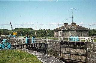

Portumna bridge lies east of the town of Portumna, in County Galway, Ireland. It is a five-span road bridge, which carries the N65 across the River Shannon to Lehinch in County Tipperary. The present bridge was designed by C. E. Stanier of London, and completed in 1911, with a central section resting on Hayes's Island which divides the river into two channels. The structure of the main bridge, consisting of steel girders supported by concrete filled cast iron cylinders, and the pivoting swing bridge over the navigation channel, are of technical and engineering interest. The house on Hayes Island, accessed from the bridge, was the bridge operator's house and pre-dates the present bridge. The opening section was replaced in October 2008.
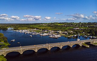
The R356 road is a regional road in Ireland; it links Killimor, County Galway with Cloghan, County Offaly. The road also travels through the towns of Eyrecourt and Banagher. At Banagher, the road crosses the River Shannon via a seven arch bridge. This bridge was erected by the Commissioners for the Improvement of Navigation of the Shannon in 1841–1843.
Clonahenoge is a townland in County Offaly, Ireland. It is located at the confluence of the Little Brosna River and the River Shannon.

The Dublin–Galway Greenway is a partially completed 'coast-to-coast' greenway and partial rail trail, in Ireland, funded by the Department of Transport, which is due to become the western section of EuroVelo EV2, a cycle route from Galway, Ireland, crossing Europe and ending in Moscow, Russia. The 276 km route was planned to be completed by 2020. It is due to be the fourth greenway in Ireland, after the Great Southern Trail, the Great Western Greenway and the Waterford Greenway.

Green and Silver is the account by Tom Rolt of a voyage through the inland waterways of Ireland just after the Second World War, published in 1949. It is notable because it was one of the last trips by any boat around the triangular loop of the River Shannon, Grand Canal and Royal Canal before the last named was closed to navigation. It was reopened in 2010.

