Chester Castle is in the city of Chester, Cheshire, England. It is sited at the southwest extremity of the area bounded by the city walls. The castle stands on an eminence overlooking the River Dee. In the castle complex are the remaining parts of the medieval castle together with the neoclassical buildings designed by Thomas Harrison which were built between 1788 and 1813. Parts of the neoclassical buildings are used today by the Crown Court and as a military museum. The museum and the medieval remains are a tourist attraction.
Athlone is a town on the border of County Roscommon and County Westmeath, Ireland. It is located on the River Shannon near the southern shore of Lough Ree. It is the second most populous town in the Midlands Region with a population of 22,869 in the 2022 census.

King John's Castle also known as Limerick Castle is a 13th-century castle located on King's Island in Limerick, Ireland, next to the River Shannon. Although the site dates back to 922 when the Vikings lived on the Island, the castle itself was built on the orders of King John of England in 1200. One of the best preserved Norman castles in Europe, the walls, towers and fortifications remain today and are visitor attractions. The remains of a Viking settlement were uncovered during archaeological excavations at the site in 1900.
Risteárd de Tiúit was an Anglo-Norman nobleman and a member of Richard de Clare, 2nd Earl of Pembroke's Irish invasion force, and Lord Chief Justice of Ireland. His part in the original invasion is acknowledged in The Song of Dermot and the Earl, which recorded his grant of land in the western part of Meath under the authority of Hugh de Lacy in Trim.

Bramber Castle is a Norman motte-and-bailey castle, formerly the caput of the large feudal barony of Bramber long held by the Braose family. It is situated in the village of Bramber, West Sussex, near the town of Steyning, overlooking the River Adur. The building is served by Brighton & Hove bus routes 2 and 60.
Jersey is a heavily fortified island with coastal fortifications that date to the English Civil War, the Napoleonic Wars, and Nazi Germany's occupation of the Channel Islands. The fortifications include castles, forts, towers, Martello towers, artillery batteries, and seawalls. Not infrequently, fortifications from one period are built on the site of earlier fortifications, or very near them, geography having remained the same even when firepower increased.
Carrigaholt is a small fishing village in County Clare, Ireland, a castle and a Catholic parish by the same name. The area was officially classified as part of the West Clare Gaeltacht; an Irish-speaking community; until 1956.
Halton Castle is a castle in the village of Halton, part of the town of Runcorn, Cheshire, England. The castle is on the top of Halton Hill, a sandstone prominence overlooking the village. The original building, a motte-and-bailey castle began in 1071, was replaced with the current sandstone castle in the 13th century. Building alterations continued until at least 1609, when the structure is recorded as in disrepair. The castle is recorded in the National Heritage List for England as a designated Grade I listed building, and a scheduled ancient monument.
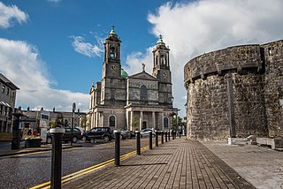
Athlone is a town on the River Shannon near the southern shore of Lough Ree in Ireland. Located on the border between County Westmeath and County Roscommon, the development of the Athlone owes much to the location of a strategic ford on the Shannon.

Ballinahown, also spelled Ballynahown, is a village in County Westmeath on the N62 regional road in Ireland. It is 10 km (6.2 mi) south of Athlone and 5 km (3.1 mi) east of the River Shannon. It contains the Roman Catholic St. Colmcilles Church, completed in 1902 to a design in the Early English Gothic-style by William Hague.

Clonony is a small village in County Offaly, Ireland. It is noted for Clonony Castle, a late medieval tower house built in 1500. The village is between the River Brosna and the Grand Canal, in the parish of Gallen and Reynegh. The nearest town is Cloghan, 2.8 km (1.7 mi) to the south-east along the R357 road. Athlone is 22 km (14 mi) to the north.

Ballymore is a village in County Westmeath, Ireland, on the R390 road between Athlone and Mullingar. The historic Hill of Uisneach is nearby. The village was known in medieval times as the medieval borough of Ballymore Lough Sewdy, or Loughsewdy, after the nearby lake, the site of an ancient bruighean, or hostel.

Street or Streete is a village and parish in County Westmeath, Ireland. It lies on the regional road between Lismacaffery and Rathowen. Its Irish name was historically anglicised as Straid or Strade.

While there are many castles in South Yorkshire, the majority are manor houses and motte-and-bailey which were commonly found in England after the Norman Conquest.
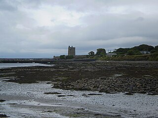
Portlick Castle is a late medieval tower house castle near the village of Glasson, County Westmeath, Ireland. It is located approximately 6 miles from Athlone on the shores of Lough Ree. It comprises a square late medieval 4-storey stone tower with an attached 2-storey Georgian wing and Victorian tower.

Ludgershall Castle is a ruined 12th-century fortified royal residence at Ludgershall in Wiltshire, England. Three large walls still remain of the castle, which was turned into a hunting lodge by Henry III but fell into disuse by the 15th century. The ruin was listed as a Scheduled Ancient Monument in 1981.

Clonlonan is a barony in south–west County Westmeath, Ireland. It was formed by 1672. It is bordered by County Offaly to the south and a small part of County Roscommon at Long Island on the River Shannon to the west. It also borders four other Westmeath baronies: Kilkenny West and Rathconrath, Moycashel and Brawny. The largest centre of population in the barony is the town of Moate.

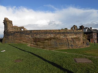
Roscrea Castle is a 13th-century motte-and-bailey castle in the town of Roscrea, Ireland. The castle consists of a walled courtyard, gate block, and angled towers. Along with 18th century Damer House and gardens, the castle forms part of Roscrea Heritage Centre.

The St. Mary's Church, Athlone is a Church of Ireland parish church situated in the town of Athlone, County Westmeath.