Castle Saunderson

Last updated • 3 min readFrom Wikipedia, The Free Encyclopedia

Castle Saunderson
Castle saunderson.jpg
Ireland adm location map.svg
Red pog.svg
General information
StatusPrivate dwelling house
TypeHouse
Architectural styleGothic revival
ClassificationRuined
Location Belturbet, County Cavan
CountryIreland
Coordinates 54°07′30″N7°21′07″W / 54.125°N 7.352°W / 54.125; -7.352
Renovated1835 (substantially remodelled)
OwnerScouting Ireland (CSI)
Technical details
Material limestone
Design and construction
Architect(s)George Sudden
DeveloperSaunderson family
References
[1]

Castle Saunderson (Irish : Caisleán Shandarsan) is a castle near Belturbet in County Cavan, Ireland. It was the former family seat of the Saunderson family, and is now in ruins. The Finn River flows along the north-eastern edge of the Castle Saunderson Demesne, where the river enters a narrow channel of Upper Lough Erne. The castle is about a half a mile west from Wattlebridge, a small hamlet in the south-south-east of County Fermanagh. [2] [3]

Contents

The Castle Saunderson International Scouting Centre is a Scouting Ireland facility, opened in 2012 within the grounds of the castle. [4] The centre provides indoor accommodation and campsites covering 34 acres (14 ha). It is open to Scouts year round, as well as to non-Scouts for most of the year. It currently acts as a World Scouting Centre for the Scouts, alongside Cairo International Scout Centre in Egypt and others.

History

Family home

The Saunderson family acquired the original castle during the Plantation of Ulster. The original castle was inhabited by the O'Reillys of Breffni and was formerly known as Breffni Castle from the 14th century. Robert Sanderson, who fought on the side of William of Orange, inherited the castle from his father in 1676. James II's troops burned the castle in 1689. Months later, 400 of King James's soldiers were ambushed here while on retreat from the battle at Newtownbutler. They were driven toward the Finn River and many drowned. [5]

The present castle dates to 1840 and was destroyed by fire in 1990. [5] A notable member of the family born there was Colonel Edward James Saunderson, a founder of the Ulster Unionist Party, and the castle hosted Orange Order events celebrating The Twelfth. [6] [7] Major Frederick John Sandys Lindesay of Loughry and Tullyhogue died there while a guest in 1877. [8] The Hon. Barry Maxwell, eldest son and heir apparent of The 10th Baron Farnham, died in a cycling accident on the estate in 1879. [9]

The last Saunderson who owned the castle was Edward's grandson, Captain Alexander "Sandy" Saunderson. [5] [10] He was a prisoner of war during the Second World War and was later present at the War Tribunal at Nuremberg as the legal advisor to Lord Justice Lawrence. [11] He sold the property to a businessman in 1977. He had planned to use it as a residence[ citation needed ], but this never transpired. It later served as a hotel,[ citation needed ] but was damaged by fire, the third fire to occur at the castle.

The Castle Saunderson Demesne, currently only 103 acres (42 ha),[ citation needed ] has entrances in County Fermanagh in Northern Ireland and County Cavan in the Republic of Ireland. The demesne includes a church with crypt and family graveyard.

International Scout Centre

In 1997 the castle and its grounds were acquired by Scouting Ireland (CSI). The subsequent formation of Scouting Ireland, and financial difficulties, delayed its development, and put the campsite project in doubt. [12] With support from the American Ireland Fund and Cavan County Council, substantial progress occurred, with the announcement in November 2008 of EU funding for the project, amounting to over €3 million. [13] [14] [15]

His Excellency Michael D. Higgins, President of Ireland, opened the €3.7 million European-funded Castle Saunderson International Scouting Centre in County Cavan on 18 August 2012. The President was joined by dignitaries from both sides of the Border, including Northern Ireland Executive Ministers Jonathan Bell, Nelson McCausland and Jennifer McCann, and Minister of State in the Republic, Fergus O’Dowd. [4]

In February 2015, Minister Heather Humphreys announced the approval of the restoration by Waterways Ireland of a canal, part of the Ulster Canal, connecting the site to the Erne basin. [16]

The site delivers programmes which complement the Messenger of Peace Award. [17]

The centre has been used by the Health Service Executive as a mass testing centre during the COVID-19 outbreak in Ireland. [18]

Related Research Articles

<span class="mw-page-title-main">County Fermanagh</span> County in Northern Ireland

County Fermanagh is one of the thirty-two counties of Ireland, one of the nine counties of Ulster and one of six counties of Northern Ireland.

<span class="mw-page-title-main">County Monaghan</span> County in Ireland

County Monaghan is a county in Ireland. It is in the province of Ulster and is part of Border strategic planning area of the Northern and Western Region. It is named after the town of Monaghan. Monaghan County Council is the local authority for the county. The population of the county was 65,288 according to the 2022 census.

<span class="mw-page-title-main">County Cavan</span> County in Ireland

County Cavan is a county in Ireland. It is in the province of Ulster and is part of the Northern and Western Region. It is named after the town of Cavan and is based on the historic Gaelic territory of East Breffny (Bréifne). Cavan County Council is the local authority for the county, which had a population of 81,704 at the 2022 census.

<span class="mw-page-title-main">Clones, County Monaghan</span> Town in County Monaghan, Ireland

Clones is a small town in the west of County Monaghan in Ireland. The area is part of the Border Region in the Republic of Ireland, earmarked for economic development by the Irish Government due to its currently below-average economic situation. The town was badly hit economically by the Partition of Ireland in 1921 because of its location on the border with County Fermanagh in Northern Ireland. The creation of the Irish border deprived it of access to a large part of its economic hinterland for many years. The town had a population of 1,680 at the 2016 census. The town is in a civil parish of the same name.

<span class="mw-page-title-main">Lough Erne</span> Lake system in Northern Ireland, UK

Lough Erne is the name of two connected lakes in County Fermanagh, Northern Ireland. It is the second-biggest lake system in Northern Ireland and Ulster, and the fourth biggest in Ireland. The lakes are widened sections of the River Erne, which flows north and then curves west into the Atlantic. The smaller southern lake is called the Upper Lough as it is higher up the river. The bigger northern lake is called the Lower Lough or Broad Lough. The town of Enniskillen lies on the short stretch of river between the lakes. The lake has more than 150 islands, along with many coves and inlets. The River Erne is 80 miles (129 km) long and drains an area of about 1,680 square miles (4,350 km2).

<span class="mw-page-title-main">Derrylin</span> Village in County Fermanagh, Northern Ireland

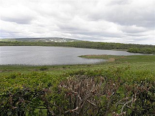
Derrylin is a village and townland in County Fermanagh, Northern Ireland. It is on the A509 road between Enniskillen and the border with County Cavan. It had a population of 634 in the 2011 census and is situated within Fermanagh and Omagh district.

<span class="mw-page-title-main">River Erne</span> River in northwestern Ireland

The River Erne in the northwest of the island of Ireland, is the second-longest river in Ulster, flowing through Northern Ireland and the Republic of Ireland, and forming part of their border.

Breffni Park, known for sponsorship reasons as Kingspan Breffni, is a GAA stadium in Cavan, Ireland. It is the home of Cavan GAA. The ground has an overall capacity of about 25,030 with a 5,030 seated capacity. Breffni is the historic name for the area of counties Cavan and Leitrim. Cavan is often referred to as the Breffni County. Kingspan Breffni is located on Park Lane to the south of Cavan town. Breffni Park hosted the first test in the 2006 Ladies' International Rules Series between Ireland and Australia. It also hosted the first test during the 2013 International Rules Series.

The Battle of Newtownbutler took place near Enniskillen in County Fermanagh, Ireland, in 1689 and was part of the Williamite War in Ireland between the forces of William III and Mary II and those of King James II.

<span class="mw-page-title-main">Ballyconnell</span> Town in County Cavan, Ireland

Ballyconnell is a town in County Cavan, Ireland. It is situated on the N87 national secondary road at the junction of four townlands: Annagh, Cullyleenan, Doon (Tomregan) and Derryginny in the parish of Tomregan, Barony of Tullyhaw.

<span class="mw-page-title-main">Ederney</span> Human settlement in Northern Ireland

Ederney is a village situated primarily in the townlands of Drumkeen and of Ederny in County Fermanagh, Northern Ireland.

<span class="mw-page-title-main">Scouting in Northern Ireland</span>

Scouting in Northern Ireland is represented by three Scouting associations:

Newtownbutler or Newtown Butler is a small town in County Fermanagh, Northern Ireland. It is in the southeast corner of the county, near Lough Erne, the border with County Monaghan, Republic of Ireland, and the town of Clones. It is surrounded by small lakes and bogland. In the 2011 census it had a population of 989 people.

<span class="mw-page-title-main">Ulster Canal</span> Disused canal in Ireland

The Ulster Canal is a canal running through part of County Armagh, County Tyrone and County Fermanagh in Northern Ireland and County Monaghan in the Republic of Ireland. The Ulster Canal was built between 1825 and 1842 and was 74 km (46 mi) long with 26 locks. It ran from Charlemont on the River Blackwater to near Wattlebridge on the Finn River, south-east of Upper Lough Erne. It was an ill-considered venture, with the locks built narrower than the other Irish waterways, preventing through trade, and an inadequate water supply. It was an abject failure commercially, and contributed to the collapse of the Lagan Navigation Company, who took it over from the government but were then refused permission to abandon it when they could not afford the maintenance costs. It finally closed in 1931. Waterways Ireland started work on rebuilding the canal at its southern end in 2015.

<span class="mw-page-title-main">Shannon–Erne Waterway</span> Canal in Ireland.

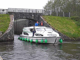
The Shannon–Erne Waterway is a canal linking the River Shannon in the Republic of Ireland with the River Erne in Northern Ireland. Managed by Waterways Ireland, the canal is 63 km (39 mi) in length, has sixteen locks and runs from Leitrim village in County Leitrim to Upper Lough Erne in County Fermanagh.

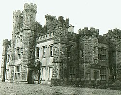
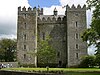
Crom Castle is a country house on the shores of Upper Lough Erne in County Fermanagh, Northern Ireland, the seat of the Earls Erne. Standing within the 1,900-acre (7.7 km2) Crom Estate, and within a formal garden, the castle is built in stone. A central battlemented tower includes the main entrance, and there are also smaller towers to one side. It stands apart from the ruins of Old Crom Castle, of which two towers, some walls, and a ha-ha survive, and near them two ancient yew trees, believed to be at least 800 years old.

<span class="mw-page-title-main">Marble Arch Caves Global Geopark</span> Lies on the Fermanagh-Cavan border, Ireland

The Cuilcagh Lakelands Geopark formerly known as the Marble Arch Caves Global Geopark straddles the border between Northern Ireland and the Republic of Ireland. It is centred on the Marble Arch Caves and in 2001 it became one of the first geoparks to be designated in Europe.

<span class="mw-page-title-main">Annagh, County Cavan</span> Townland in County Cavan, Ireland

Annagh is a townland in the Parish of Tomregan, Barony of Tullyhaw, County Cavan, Ireland.

<span class="mw-page-title-main">Finn River (County Fermanagh and County Monaghan)</span> Small river in Ulster, Ireland

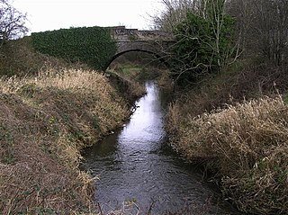
The Finn River, also known as the River Finn, is a small river that flows through parts of County Fermanagh and parts of County Monaghan in the south of Ulster, the northern province in Ireland. In certain places, the river forms part of the boundary between County Fermanagh, which is part of Northern Ireland, and County Monaghan, which is part of the Republic of Ireland. Two very short stretches of the river, just north of Redhills and at Castle Saunderson, near Belturbet, also form part of the boundary between County Fermanagh and County Cavan. This means that some stretches of the river form part of the border between Northern Ireland and the Republic of Ireland, these short stretches also forming part of the external border of the European Union.

Wattlebridge, sometimes written as Wattle Bridge, is a small hamlet in the south-south-east of County Fermanagh in Northern Ireland. The hamlet is located almost 3½ miles south of the village of Newtownbutler. The hamlet is in a region known unofficially as South Ulster.

References

  1. "Castle Saunderson". www.dia.ie. Retrieved 19 June 2024.
  2. Discoverer Series Sheet 27 (Edition F). Ordnance Survey of Northern Ireland (O.S.N.I.), Land and Property Services, Belfast, 2019.
  3. Barbara Chapman, A History of Newtownbutler, p. 30. Nonsuch Publishing, Lower Leeson Street, Dublin, 2005.
  4. 1 2 "Scouts' honour: President cuts ribbon at €3.7m scouts' centre". The Irish Times. 20 August 2012. Retrieved 20 October 2013.
  5. 1 2 3 Information sign outside the caste, 2018
  6. Maume, Patrick (1995). "Colonel Edward Saunderson: Land and Loyalty in Victorian Ireland". Irish Economic and Social History. 22: 147–149. doi:10.1177/033248939502200121. JSTOR   24341477. S2CID   164715405.
  7. "Colonel Saunderson, M.P., And His Constituents". Belfast News Letter . 24 August 1894. p. 7. Retrieved 16 June 2020 via Newspapers.com.
  8. "Calendars of Wills and Administrations, 1858-1922, The National Archives of Ireland" (PDF). 1878.
  9. Mórdha, P. B. Ó. (1992). "Notes and Comments". Bits and Pieces. 14 (2). Clogher Record: 132. JSTOR   27699347.
  10. "Alexander".
  11. "Interview with Sandy Saunderson. Film available for download". 1988.
  12. "Conclusion of Castle Saunderson Project". Scouting Ireland. 2006. Archived from the original on 30 October 2007. Retrieved 3 March 2015.
  13. "Castle Saunderson". American Ireland Funds Golf Classic 2005. American Ireland Fund. 2005. Archived from the original on 16 February 2006. Retrieved 3 March 2015.
  14. "Castle Saunderson". American Ireland Funds Golf Classic 2004. American Ireland Fund. 2004. Archived from the original on 11 April 2005. Retrieved 3 March 2015.
  15. "Campsite Locator". Scouting Ireland. Archived from the original on 19 October 2014. Retrieved 20 October 2013.
  16. "Minister Humphreys secures Government approval to restore Ulster Canal from Upper Lough Erne to Castle Saunderson" (Press release). Department of Arts, Heritage and the Gaeltacht. 24 February 2015. Archived from the original on 24 February 2015. Retrieved 24 February 2015.
  17. "CASTLE SAUNDERSON PEACE AWARD". Castle Saunderson International Scout Centre. Archived from the original on 24 March 2016. Retrieved 16 May 2016.
  18. "Council to repair test centre entrance". AngloCelt.ie . 12 January 2022. Retrieved 19 January 2022.