Huntington Castle, Clonegal

Last updated

Huntington Castle Huntington Castle.jpg
Huntington Castle

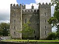
Huntington Castle, also known as Clonegal Castle, is a castle in Clonegal, County Carlow, Ireland, built in 1625.

Contents

The structure was originally a "plantation castle", [1] used for defensive purposes during the plantation of the area in the early 17th century. The original tower house, which served as a garrison, was built in the 15th century as a stronghold for the Caviness family, an old Irish clan. Due to the strategic importance of the village of Clonegal during the Cromwellian conquest of Ireland because of its location on the road between Dublin and Wexford, the castle was captured by Oliver Cromwell as he marched on Kilkenny [2] in 1650.

It is now a private house open to the public for guided tours throughout June, July, August and September. It was the setting for Stanley Kubrick's film Barry Lyndon . Its basement has been the base of a religion, the Fellowship of Isis, since 1976, [3] The castle hosted the Solas Festival in August 2008. [4] co-founded by Olivia Robertson, her brother Lawrence Durdin-Robertson and his wife Pamela. The castle is now owned by Alexander and Claire Durdin Robertson.

Gardens

The Esmonde family laid out most of the gardens in the 17th century. This includes the French limes on the Avenue, the parterre or lawns to the side of the house, the fish ponds on either side of the centre walk through the wilderness and the majority of yew trees which comprise the Yew Walk. Larger plantings have resulted in Huntington possessing a number of great Irish trees, including varieties of hickory, a cut leaved oak, Siberian crab and buckeye chestnut. A lake at the bottom of the wilderness was built for ornamental purposes but next to it is one of the earliest water turbine houses in Ireland, providing Huntington with its own electricity as early as 1888. The River Derry, which forms the boundary between Counties Wexford and Carlow, flows along the bottom of the wilderness, providing a pleasant setting for woodland walks.

Ghosts

There have been various myths that Huntington castle has been plagued by ghosts of druids in the fields and even in the castle. [5] It is said that the druids could, at a stroke, create a mist; start fires at will; and bring down showers of blood. They were feared because they would sacrifice men and women to please their gods.

See also

Related Research Articles

<span class="mw-page-title-main">County Carlow</span> County in Ireland

County Carlow is a county located in the Southern Region of Ireland, within the province of Leinster. Carlow is the second smallest and the third least populous of Ireland's 32 traditional counties. Carlow County Council is the governing local authority.

<span class="mw-page-title-main">River Barrow</span> Second-longest river in Ireland, one of the Three Sisters

The Barrow is a river in Ireland. It is one of The Three Sisters; the other two being the River Suir and the River Nore. The Barrow is the longest of the three rivers and, at 192 km (120 mi), the second-longest river in Ireland, behind the River Shannon. The catchment area of the River Barrow is 3,067 km2 before the River Nore joins it a little over 20 km before its mouth. The river's long term average flow rate, again before it is joined by River Nore, is 37.4 cubic metres per second. At the merger with the River Suir, its catchment area is ca. 5,500 km2 and its discharge over 80 m3/s.

<span class="mw-page-title-main">Wicklow Way</span> Walking trail in County Wicklow, Ireland

The Wicklow Way is a 131-kilometre (81-mile) long-distance trail that crosses the Wicklow Mountains in Ireland. It runs from Marlay Park in the southern suburbs of Dublin through County Wicklow and ends in the village of Clonegal in County Carlow. It is designated as a National Waymarked Trail by the Irish Sports Council and is waymarked by posts with a yellow "walking man" symbol and a directional arrow. Typically completed in 5–7 days, it is one of the busiest of Ireland's National Waymarked Trails, with up to 24,000 people a year walking the most popular sections. The Way is also used regularly by a number of mountain running competitions.

The Fellowship of Isis (FOI) is a multi-faith, multi-racial, and multi-cultural spiritual organization focused on increasing awareness for the Goddess Isis. The Fellowship of Isis believes Isis best represents the energies of the dawning Aquarian Age. Despite worshipping pagan deities, the fellowship does not consider itself to be a Neopagan faith.

<span class="mw-page-title-main">Bunclody</span> Town in County Wexford, Ireland

Bunclody, formerly Newtownbarry, is a small town on the River Slaney in Wexford, Ireland. It is located near the foot of Mount Leinster. Most of the town is in County Wexford; a small area at the north end of town is in County Carlow. Bunclody has received a number of high scores in the Tidy Towns competition. The town is known for the "Streams of Bunclody Festival" held during the month of July.

<span class="mw-page-title-main">Clonegal</span> Village in County Carlow, Ireland

Clonegal, officially Clonegall, is a village in the southeast of County Carlow, Ireland. It is in a rural setting, close to the border between counties Wexford and Carlow, 5 km (3 mi) from Bunclody, County Wexford and 22 km (14 mi) from Carlow town. It is just over a mile north of where the River Slaney and the River Derry meet. Clonegal has a much smaller "twin" village across the River Derry in County Wexford, Watch House Village.

<span class="mw-page-title-main">Daniel Robertson (architect)</span> British architect

Daniel Robertson was a British architect.

<span class="mw-page-title-main">Thomas Herbert Robertson</span> British lawyer and politician

(Thomas) Herbert Robertson was a British barrister and Conservative politician.

<span class="mw-page-title-main">Paulstown</span> Village in County Kilkenny, Ireland

Paulstown is a small village in County Kilkenny in Ireland.

<span class="mw-page-title-main">Ballymoon Castle</span> Ruined castle in County Carlow, Ireland

Ballymoon Castle is a National Monument situated 2 miles (3 km) east of Bagenalstown, County Carlow, Ireland. The castle is thought to date from the 13th century.

This is a list of coats of arms of Ireland. In the majority of cases these are arms assigned to county councils created by the Local Government (Ireland) Act 1898 or later legislation, either by the Chief Herald of Ireland in what is now the Republic of Ireland or by the College of Arms in Northern Ireland. All but two county councils in the Republic have a coat of arms. In Northern Ireland, county councils were abolished in 1973, but the traditional arms are still occasionally used.

<span class="mw-page-title-main">Olivia Robertson</span>

Olivia Melian Durdin-Robertson was an author, artist, co-founder and high priestess of the Fellowship of Isis.

The 2012 National Hurling League commenced in February 2012. 34 GAA county hurling teams: 32 from Ireland, London and Warwickshire, contested it.

<span class="mw-page-title-main">Enniscorthy Castle</span> Historic site in County Wexford, Ireland

Enniscorthy Castle is situated in Enniscorthy, County Wexford, Ireland. Construction on the castle commenced in the late 1190s and was first occupied by its Norman owners in 1203 A.D. on the site of a previous wooden castle they had erected some years earlier. It was built by Philip De Prendergast

Dunleckney Manor is a manor house in Bagenalstown, County Carlow, Ireland.

Huntington Castle may refer to:

<span class="mw-page-title-main">Mountgarret</span> Townland in County Wexford, Ireland

Mountgarret is a townland in New Ross, County Wexford, Ireland. It is known for the ruins of a medieval tower house that was built by the Bishop of Ferns in 1408.

<span class="mw-page-title-main">Slade, County Wexford</span> Townland in County Wexford, Ireland

Slade is a small village and townland in County Wexford, Ireland. The townland, which has an area of approximately 1 square kilometre (0.4 sq mi), sits on the Hook Peninsula and had a population of 52 people as of the 2011 census. Slade has historically been a fishing port, and was defended by Slade Castle from the late 15th century. In the south of the townland, there is evidence of an earlier ringfort. The harbour in Slade village was extended in the mid-19th century and built upon piers dating from at least the 17th century. A salt-house was built here in the 17th century, to salt (preserve) the fish landed in the harbour. There is a small beach next to the harbour, and Hook Sub Aqua Club is based nearby.

References

  1. Williams, Jeremy (1994). A Companion Guide To Architecture in Ireland 1837 - 1921. Irish Academic Press. p. 39. ISBN   0-7165-2513-5.
  2. Heron, Marianne (1999). The Hidden Houses of Ireland. Gill & Macmillan Ltd. pp. 28–30. ISBN   0-7171-2730-3.
  3. Rowan Kelleher, Suzanne (2004). Frommer's Ireland 2004 (14 ed.). John Wiley and Sons. pp.  177. ISBN   0-7645-4216-8.
  4. Newenham, Pamela (18 August 2008). "Bad weather, mess and muck 'but the vibe was great'". Irish Times. Retrieved 12 June 2009.
  5. "Castle Ghosts of Ireland (HD) (1995) (COMPLETE EPISODE)". YouTube .

52°41′23″N6°38′55″W / 52.6898°N 6.6486°W / 52.6898; -6.6486