
County Sligo is a county in Ireland. It is in the Northern and Western Region and is part of the province of Connacht. Sligo is the administrative capital and largest town in the county. Sligo County Council is the local authority for the county. The population of the county was 70,198 at the 2022 census. It is noted for Benbulben Mountain, one of Ireland's most distinctive natural landmarks.

The River Moy is a river in the northwest of Ireland.

The River Erne in the northwest of the island of Ireland, is the second-longest river in Ulster, flowing through Northern Ireland and the Republic of Ireland, and forming part of their border.

Ballysadare, locally also Ballisodare, is a town in County Sligo, Ireland. It is about 7 km (4 mi) south of Sligo town. The town developed on an important crossing of the Owenmore River. Ballysadare is in a townland and civil parish of the same name.

The Garavogue or Garvoge (Irish: An Gharbhóg is a river in County Sligo, northwest Ireland, known historically as the Sligeach or Sligo River.

The Arney River is a small river in County Fermanagh, Northern Ireland, feeding from Lower Lough MacNean and into Upper Lough Erne. It meanders through a wide, flat Glacial Trough between the uplands of Fermanagh, Belmore Mountain and the Cuilcagh Mountains. The valley is characterised by wide flat lowlands enclosed by low hills. The Cladagh River drains into the Arney River.

The River Fergus is a river within the Shannon River Basin which flows in County Clare, Ireland. The river begins at Lough Fergus in north Clare and flows into the Shannon Estuary. The source is at Lough Fergus in the townland of Kilmore North.
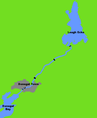
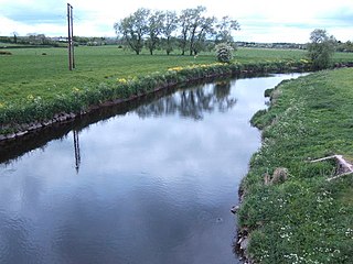
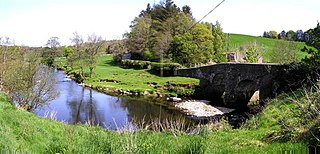
The River Eske is a river in County Donegal, Ireland. It begins at Lough Eske in the southeast of the county before flowing mainly westwards to the town of Donegal and into the Atlantic Ocean via Donegal Bay.

The Castletown River is a river which flows through the town of Dundalk, County Louth, Ireland. It rises near Newtownhamilton, County Armagh, Northern Ireland, and is known as the Creggan River in its upper reaches. Its two main tributaries are the Kilcurry and Falmore rivers and it enters the Irish Sea at Dundalk Bay.

The River Bush is a river in County Antrim, Northern Ireland. The River Bush is 33.5 miles (53.9 km) long. The river's source is in the Antrim Hills at 480m. From there the river flows northwest, with a bend at the town of Armoy. It then flows west, passing through Stranocum, and then bends north, passing through Bushmills before reaching the sea at Portballintrae on the North Antrim coast. It flows through a fertile valley devoted to grassland-based agriculture with limited arable cropping. The underlying geology is basalt and the water is slightly alkaline with magnesium making an unusually large contribution to total hardness. The river supports indigenous stocks of Atlantic salmon and brown trout. Saint Columb's Rill, which is a tributary of the river, is the source of water used for distilling Bushmills whiskey.

The River Duff, or Bunduff, is a river in County Sligo and County Leitrim, Ireland. The River Duff is 14 miles (23 km) long, flowing from Glenade Valley in County Leitrim to the sea. In County Leitrim it is also known as the Black River. It is joined by the Ballanaghtrillick River, which runs out of the Horseshoe Pass.

Sligo Bay is a natural ocean bay in County Sligo, Republic of Ireland.
The River Main or Maine is a river in Northern Ireland, flowing through County Antrim.

The River Maine is a river in County Kerry, Ireland.

The River Lennon or Leannan is a river in County Donegal, Ireland.
The River Faughan is a river in northwest Northern Ireland.

The River Erriff is a river in Ireland, flowing through County Mayo. A spate river, it is characterised by lively streams and deep fish-holding pools. A waterfall called Aasleagh Falls is near the mouth of the river.

The River Anner is a river in Ireland, flowing through County Tipperary, a tributary of the Suir.

The Glenamoy River is a river in north County Mayo, in the northwest of Ireland. It contains sea trout and salmon.

The Coolera Peninsula is a peninsula in Sligo Bay, County Sligo, Ireland. It is the most populous of County Sligo's peninsulas, and the second-largest by land area. The primary population centres on Coolera are the coastal town of Strandhill on its western shore, and Magheraboy, a suburb of Sligo town.

