County Leitrim is a county in Ireland. It is in the province of Connacht and is part of the Northern and Western Region. It is named after the village of Leitrim. Leitrim County Council is the local authority for the county, which had a population of 35,087 according to the 2022 census.
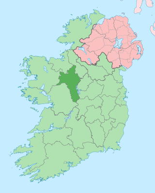
County Roscommon is a county in Ireland. It is part of the province of Connacht and the Northern and Western Region. It is the 11th largest Irish county by area and 27th most populous. Its county town and largest town is Roscommon. Roscommon County Council is the local authority for the county. The population of the county was 69,995 as of the 2022 census.

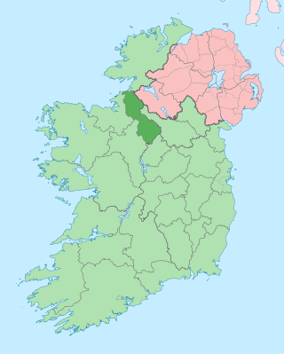
County Sligo is a county in Ireland. It is located in the Border Region and is part of the province of Connacht. Sligo is the administrative capital and largest town in the county. Sligo County Council is the local authority for the county. The population of the county was 65,535 at the 2016 census. It is noted for Benbulben Mountain, one of Ireland's most distinctive natural landmarks.

The Eurasian curlew or common curlew is a very large wader in the family Scolopacidae. It is one of the most widespread of the curlews, breeding across temperate Europe and Asia. In Europe, this species is often referred to just as the "curlew", and in Scotland known as the "whaup" in Scots.
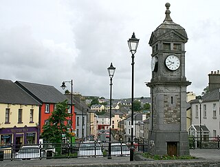
Boyle is a town in County Roscommon, Ireland. It is located at the foot of the Curlew Mountains near Lough Key in the north of the county. Carrowkeel Megalithic Cemetery, the Drumanone Dolmen and the lakes of Lough Arrow and Lough Gara are also close by. As of 2016, the population of the town was 2,568.

Lough Gill is a freshwater lough (lake) mainly situated in County Sligo, but partly in County Leitrim, in Ireland. Lough Gill provides the setting for William Butler Yeats' poem "The Lake Isle of Innisfree".

Ballysadare, locally also Ballisodare, is a town in County Sligo, Ireland. It is about 7 kilometres south of Sligo town. The town developed on an important crossing of the Owenmore River.
Monasteraden is a village in County Sligo, Ireland. The village is located on the shores of Lough Gara. St Aiden's church is the village's church. Other sites include Lough Gara Lodge, Slí na Croí's Roundhouse Ecolodge, Drury's pub and the general store.

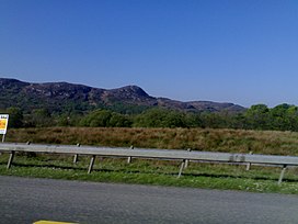
The Battle of Curlew Pass was fought on 15 August 1599 during the campaign of the Earl of Essex in the Nine Years' War, between an English force under Sir Conyers Clifford and a rebel Irish force led by Aodh Ruadh Ó Domhnaill. The English were ambushed and routed while marching through a pass in the Curlew Mountains, near the town of Boyle, in the west of Ireland. The English forces suffered heavy casualties. Losses by allied Irish forces were not recorded but were probably minimal.

Blacklion is a border village in west County Cavan, Ireland. It is situated on the N16 national primary road, just across the border from the County Fermanagh village of Belcoo.
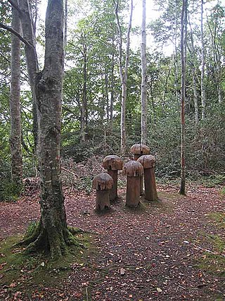
Hazelwood is an ancient area of woodland located just over 2 miles (3.2 km) outside the town of Sligo in northwest Ireland, in the parish of Calry. It is the setting for W.B.Yeats's The Song of Wandering Aengus. The wood is situated on the shores of Lough Gill, which contains Yeats's Lake Isle of Innisfree, and is popular for its scenic walks, which are dotted with sculptures. Swans, mallards and gulls congregate at the picnic area, and there is fishing on Lough Gill. The wood is part of the Hazelwood estate, owned by the Wynne family for two hundred years. The walk along forests trails provides views of the lake and Church Island, Cottage Island and Goat Island.

Ballynary is the name of a townland on the eastern shore of Lough Arrow in the southern corner of County Sligo in Ireland. Ballynary was the ancestral seat of the O'Higgins family for 700 years, until they were forced off their lands in 1654 by Oliver Cromwell.

The Diocese of Elphin is a Roman Catholic diocese in the western part of Ireland. It is in the Metropolitan Province of Tuam and is subject to the Metropolitan Archdiocese of Tuam. The current bishop is Kevin Doran who was appointed in 2014.
The Roman Catholic Diocese of Achonry is a Roman Catholic diocese in the western part of Ireland. It is one of the five suffragan sees of the Archdiocese of Tuam. The diocese was often called the "bishopric of Luighne" in the Irish annals. It was not established at the Synod of Rathbreasail, but Máel Ruanaid Ua Ruadáin signed as "bishop of Luighne" at the Synod of Kells.

Benbulbin, sometimes Benbulben or Ben Bulben, is a large flat-topped nunatak rock formation in County Sligo, Ireland. It is part of the Dartry Mountains, in an area sometimes called "Yeats Country".

Lough Gara is a lake in Counties Sligo and Roscommon, Ireland. It is an Important Bird Area protecting 1,788 ha of which most is covered by a Ramsar Site.
Kilfree Junction is a former station in County Sligo and was located on the Sligo line in the townland of Cloontycarn between Boyle and Ballymote about 1 mile (1.6 km) from the track summit though the Curlew Mountains. It enabled connections on the branch line to Ballaghaderreen in County Roscommon. The junction faced Ballymote and Sligo station and was a trailing junction in the Boyle and Dublin Connolly direction requiring a reversal. The station was not located near any significant settlement, the nearest, Gorteen in County Sligo being over 6 km away.

The Bricklieve Mountains or Bricklieve Hills are a range of hills in south County Sligo, Ireland. They are dotted with ancient passage tombs known as the Carrowkeel tombs or Bricklieve tombs. The name of the hills is a possible reference to their appearance when more quartz rock survived outside the cairns, making them sparkle in the sun. The hills cover an area of 25 square kilometres (9.7 sq mi) and include only two major hills, Carrowkeel at 321 metres (1,053 ft), and Kesh Corann at 359 metres (1,178 ft). The Caves of Kesh are on the west side of Kesh Corran.

Boyle is a barony in County Roscommon, Republic of Ireland.

The Coolera Peninsula is a peninsula in Sligo Bay, County Sligo, Ireland. It is the most populous of County Sligo's peninsulas, and the second-largest by land area. The primary population centres on Coolera are the coastal town of Strandhill on its western shore, and Magheraboy, a suburb of Sligo town.