County Leitrim is a county in the Republic of Ireland. It is in the province of Connacht and is part of the Border Region. It is named after the village of Leitrim. Leitrim County Council is the local authority for the county, which had a population of 32,044 according to the 2016 census. The county encompasses the historic Gaelic territory of West Breffny (Bréifne) corresponding to the northern part of the county, and Muintir Eolais or Conmaicne Réin, corresponding to the southern part.

The Western Way is a long-distance trail in Ireland. It is 179 kilometres long and begins in Oughterard, County Galway and ends in Ballycastle, County Mayo. It is typically completed in seven days. It is designated as a National Waymarked Trail by the National Trails Office of the Irish Sports Council and is managed by Coillte, Galway County Council, Mayo County Council, South Mayo Development Company and Mayo North & East Development Company.

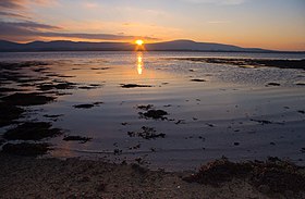
Lough Gill is a freshwater lough (lake) mainly situated in County Sligo, but partly in County Leitrim, in Ireland. Lough Gill provides the setting for William Butler Yeats' poem "The Lake Isle of Innisfree".
The Sligo, Leitrim and Northern Counties Railway (SL&NCR) was a 5 ft 3 in railway in counties Cavan, Fermanagh, Leitrim and Sligo in north-west Ireland. It consisted of one main line, with no branch lines and remained privately owned until its closure.

Monasteraden is a village in County Sligo, Ireland. The village is located on the shores of Lough Gara. St Aiden's church is the village's church. Other sights include Lough Gara Lodge, Slí na Croí's Roundhouse Ecolodge, Drury's pub and the general store.

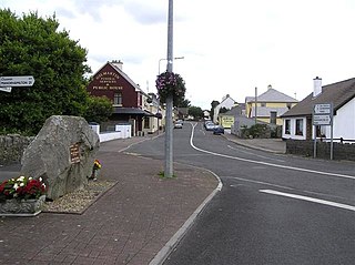
Dromahair is a village in County Leitrim, Ireland. Dromahair is 10 km (6 mi) from Manorhamilton and 17 km (10 mi) from Sligo town.
Kinlough is a village in north County Leitrim. It lies between the Dartry Mountains and the Atlantic Ocean, and between the River Duff and the River Drowes, at the head of Lough Melvin. It borders counties Donegal and Fermanagh and is near Yeats Country. It lies 2.5 miles from Bundoran, County Donegal, and across Lough Melvin from Garrison, County Fermanagh.

Blacklion is a border village in west County Cavan, Ireland. It is situated on the N16 national primary road, just across the border from the County Fermanagh village of Belcoo.

The R295 road is a regional road in Ireland that runs from Ballymote, County Sligo to Boyle, County Roscommon.

The Dartry Mountains are a mountain range in the north west of Ireland, in the north of counties Sligo and Leitrim. They lie between Lough Melvin, Lough Gill and Lough MacNean. The highest point is Truskmore at 647 metres (2,123 ft). Other notable mountains include Benbulbin at 526 metres (1,726 ft), Benwiskin at 514 metres (1,686 ft), and Tievebaun at 611 metres (2,005 ft).

The Ox Mountains or Slieve Gamph are a mountain range in County Sligo on the west coast of Ireland. They are also known as Saint Patrick's Mountains after the saint who built churches on its slopes and left his name to some of its wells.

Lough Gara is a lake in Counties Sligo and Roscommon, Ireland. It is an Important Bird Area protecting 1,788 ha of which most is covered by a Ramsar Site.

Lough Talt is a lake in the Ox Mountains of south County Sligo, Ireland. The lake is located between the villages of Tubbercurry and Bonniconlon on the R294 road. Lough Talt is part of the Lough Hoe Bog Special Area of Conservation, an area of montane bogland and oligotrophic lakes.

The Miners' Way and Historical Trail is a long-distance trail in Ireland. It is a 118-kilometre (73-mile) long circular route that begins and ends in Arigna, County Roscommon. It is typically completed in five days. It is designated as a National Waymarked Trail by the National Trails Office of the Irish Sports Council and is managed by Roscommon Integrated Development Company, Roscommon County Council, Leitrim County Council and Sligo County Council. The trail was developed to encourage tourism in the area in the wake of the closure of the Arigna mines in 1990. The route was originally conceived by a local priest, Father Sean Tynan, and built with funding from the European Regional Development Fund. The trail was opened by broadcaster Donncha Ó Dúlaing in July 2000.

The Sligo Way is a long-distance trail mainly in County Sligo, Ireland. It is 78 kilometres long and begins in Larrigan, near Lough Talt and ends in Dromahair, County Leitrim. It is typically completed in three days. It is designated as a National Waymarked Trail by the National Trails Office of the Irish Sports Council and is managed by Sligo County Council, Sligo Integrated Development Company and the Sligo Walks Partnership.

Glencar Lough, locally known as Glencar Lake, is a freshwater lake in the northwest of Ireland. It covers an area of 1.15 square kilometres and lies mostly in County Leitrim with a smaller part in County Sligo. Glencar Waterfall is located near the lake's north shore on the Leitrim side.

Easky Lough, also known as Easkey Lough or Lough Easky, is a freshwater lake in the northwest of Ireland. It is located in west County Sligo in the Ox Mountains.

Lough Arrow is a freshwater lake in the northwest of Ireland. This large, scenic lake covers an area of 12.47 square kilometres (4.8 sq mi) and lies mostly in County Sligo with a smaller part in County Roscommon. It is a popular trout fishing lake.

The R286 road is a regional road in Ireland. It is largely a loop road from the N16 linking Sligo and north County Leitrim.