Benbulbin

Last updated

Benbulbin
Benbulbenmount.jpg
Benbulbin's northern side on a cloudy day.
Highest point
Elevation 526 m (1,726 ft)
Listing Marilyn
Coordinates 54°22′N8°28′W / 54.367°N 8.467°W / 54.367; -8.467
Naming
Native nameBinn Ghulbain (Irish)
Geography
Ireland relief location map.png
Red triangle with thick white border.svg
Benbulbin
Location in Ireland
Location County Sligo, Ireland
Parent range Dartry Mountains
OSI/OSNI grid G692463
Topo map OSi Discovery 16
Climbing
Easiest route Hike

Benbulbin (Irish : Binn Ghulbain), [1] sometimes Benbulben or Ben Bulben, is a large flat-topped nunatak [2] rock formation in County Sligo, Ireland. It is part of the Dartry Mountains, in an area sometimes called "Yeats Country". [3] [4] [5]

Contents

Benbulbin is a protected site, designated as a County Geological Site by Sligo County Council. [6] [7]

Etymology

"Benbulbin", "Benbulben" and "Ben Bulben" are all anglicisations of the Irish name "Binn Ghulbain". "Binn" means "peak" or "mountain"; "ghulbain" may mean beak or jaw, or may refer to Conall Gulban, a son of Niall of the Nine Hostages, who was associated with the mountain. [3] [8]

Geology

Benbulbin from Mullaghmore Head, with Classiebawn Castle in the foreground Benbulben love.jpg
Benbulbin from Mullaghmore Head, with Classiebawn Castle in the foreground

Formation

Benbulbin was shaped during the ice age, when Ireland was under glaciers. Originally it was a large plateau. Glaciers moving from the northeast to southwest shaped it into its present distinct formation. [4] [9]

Rock composition

Benbulbin, and the Dartry Mountains as a whole, are composed of limestones on top of mudstones. These rocks formed in the area approximately 345-330 million years ago in the Viséan Stage of the Carboniferous Period. The environment was a shallow sea. Uppermost in the limestone layer is a thicker, harder limestone called the Dartry Limestone Formation. [10] Below this is a thinner transitional limestone formation – the Glencar Limestone Formation. Further down, the lower slopes consist of shaly mudstone known as the Benbulben Shale Formation. [11] Scree deposits are found near the base. [4] [6]

Fossils exist throughout the layers of the mountains. All layers have many fossilised sea shells. The shale layer also holds some corals. [6]

Baryte was mined at Glencarbury near Benbulbin in the Dartry range between 1894 and 1979. [6]

Climbing

Benbulbin across Sligo Bay Benbulbin July 2020.jpg
Benbulbin across Sligo Bay

Benbulbin is an established walking destination. [12] [13] [14] If climbed by the north face, it is a hazardous climb. That side bears the brunt of the high winds and storms that come in from the Atlantic Ocean. However, if approached by the south side, it is an easy walk, since that side slopes very gently. From the summit there are views over the coastal plain of north County Sligo and the Atlantic ocean. [4] The land adjacent to the western edge of the ridge is privately owned farmland and not accessible to the general public. However, there is a paved path up the south face to the east near Glencar Waterfall just over the County Leitrim border.

Walking

One of the trails running alongside Benbulbin mountain is the Gortarowey Looped Walk, which runs both through the forest and out in the open, overlooking Benbulbin and Donegal Bay. It is 5.5 kilometres (3 mi) in length and takes approximately 1.5 hours to walk. [15]

Flora and fauna

Benbulbin hosts a variety of plants, including some found nowhere else in Ireland. Many are Arctic–alpine species, due to the mountain's height, which allows for cooler temperature at altitude than the surrounding terrain. These plants are believed to have evolved and established themselves just after the glaciers that formed Benbulbin had receded. In 2012, research revealed that the fringed sandwort found growing on Benbulbin (found nowhere else in the country) has, indeed, been present since the last ice age; the endemic plants are thought to be collectively around 100,000 years old. This discovery reopens the debate over whether or not Ireland's ecology, as we know it today, predates the Ice Age. [16] Other notable flora found on Benbulbin includes Alpine saxifrage, Arabidopsis spp., arctic meadow-rue, bluebells, Meconopsis spp., Poa alpina , Polystichum lonchitis , and snowbed willow.

Wild badger, hare and red fox may be seen in the area. [4] The formation also hosts a population of red-billed chough—birds with a similar appearance to crows, ravens and other Corvids, albeit with bright red bills.

In Irish history

One of the Carrowmore tombs and Benbulbin County Sligo - Carrowmore Passage Tomb - 20190922144246.jpg
One of the Carrowmore tombs and Benbulbin
Northern side Benbulben.jpg
Northern side

Irish legends

Benbulbin is the setting of several Irish legends. It is said to be one of the hunting grounds of the Fianna, a band of warriors who are said to have lived in the 3rd century. One example is the story of The Pursuit of Diarmuid and Gráinne , [17] in which the warrior Diarmuid Ua Duibhne (Diarmuid) is tricked by Fionn mac Cumhaill (Finn McCool) into fighting an enchanted boar, which later kills the warrior by piercing his heart with its tusk. McCool is also said to have found his long-lost son Oisín at this location. The mountain is said to be Diarmuid and Gráinne's resting place. Also, in the 6th century, St. Columba fought a battle on the plain below Benbulbin at Cúl Dreimhne (Cooladrumman) for the right to copy a Psalter he had borrowed from St. Finnian. [18]

Irish Civil War

On 20 September 1922, during the Irish Civil War, an Irish Republican Army column, including an armoured car were cornered in Sligo. The car was destroyed by another armoured car belonging to the Irish Free State's National Army, and six of the IRA soldiers fled up the Benbulbin's slopes. In the end, all were killed, allegedly after they had surrendered. They are known as the "Noble Six". Brigadier Seamus Devins TD, Div. Adj. Brian MacNeill, Capt. Harry Benson, Lieut. Paddy Carroll, Vols. Tommy Langan and Joe Banks were those killed on the mountain. [19] The six anti-treaty fighters were hunted down on the slopes of Benbulbin and put to death by Free State forces which were out to avenge the killing of Brigadier Joseph Ring eight days earlier. Two of those killed and Ring were ancestors of current and recent politicians: Ring is the grand uncle of Michael Ring, McNeill is the uncle of former Tánaiste and Minister for Justice, Equality and Law Reform Michael McDowell and Devins is the grandfather of Jimmy Devins. [20] Mary O'Rourke once narrated a radio documentary telling how her grandmother's home was used as a safehouse. [20]

Plane crashes

During World War II there were two plane crashes in the Dartry mountains close to Benbulbin.

On 9 December 1943, a USAAF Boeing B-17G Flying Fortress plane (en route from Goose Bay, Labrador to Prestwick, Scotland) crashed on Truskmore just east of Benbulbin. 10 airmen were aboard, of whom three died, two at the scene and one from injuries sustained in the crash. [21] Local residents undertook a rescue mission, taking the injured off the mountain where they were then transferred to Sligo County Hospital. Substantial wreckage of the plane stayed on the mountain for many years following the crash and today limited amounts of aircraft fragments still remain at the site. [21]

Near the location of the Flying Fortress crash, there was an earlier crash also involving a military aircraft. On 21 March 1941, an RAF Catalina flying boat (AM265) using the Donegal Corridor crashed into the mountain at Glenade, County Leitrim on the east side of Truskmore. All nine airmen aboard died in the crash. [21] [22]

Recent history

In the 1970s and 1980s, Sinn Féin had engaged in a slogan campaign around the theme 'Brits out of Ireland'. Roads and walls throughout Ireland had been marked with these slogans as was Benbulbin in 1977. It was marked first with 'Brits Out' (180 ft wide and 25 ft high) and then later with the slogan 'H-Block'.[ citation needed ]

Benbulbin overlooks the village of Mullaghmore, the site of the assassination of Lord Mountbatten in 1979. [23] [24]

As stated above, Benbulbin is a protected site, designated as a County Geological Site by Sligo County Council. However, in May 2018, 'Vote No' (8th amendment) campaigners erected a large "NO" sign, severely impacting the iconic view. Sligo County Council responded on social media with the following statement, "As the land where the lettering was placed is commonage, Sligo County Council has no role in this matter". The sign was removed the next day. [25]

Notable people

The athlete Mary Cullen is from nearby Drumcliffe. [26] Andy "The Bull" McSharry, involved in a famous 17-year-long dispute over allowing access rights over his land, lives near Benbulbin. [27]

In literature

Benbulbin features prominently in the poetry of W. B. Yeats, after whom Yeats Country is named. [17] County Sligo is considered integral to the poet's work. [28] The mountain is one of the destinations on the Passport Trail of the poet's life. [28]

Yeats wrote the following in The Celtic Twilight:

But for Ben Bulben and Knocknarea,
Many a poor sailor'd be cast away
. [29]

The mountain is also mentioned in Yeats's On a Political Prisoner, in which he recalls the Countess Markiewicz riding past it to political meetings. [17]

Yeats's famous poem, Under Ben Bulben , is essentially a description of Yeats Country. It describes the sights that he saw in Yeats Country. The following is an excerpt from Under Ben Bulben:

Under bare Ben Bulben's head
In Drumcliff churchyard Yeats is laid.
An ancestor was rector there
Long years ago, a church stands near,
By the road an ancient cross.
No marble, no conventional phrase;
On limestone quarried near the spot
By his command these words are cut:

Cast a cold eye
On life, on death.

Horseman, pass by!

Under Ben Bulben, W.B. Yeats

This was Yeats's final poem, published in The Irish Times . [30] He is buried in Drumcliffe Churchyard, in the shadow of Benbulbin. [17] [30] [31]

See also

Related Research Articles

<span class="mw-page-title-main">County Sligo</span> County in Ireland

County Sligo is a county in Ireland. It is in the Northern and Western Region and is part of the province of Connacht. Sligo is the administrative capital and largest town in the county. Sligo County Council is the local authority for the county. The population of the county was 70,198 at the 2022 census. It is noted for Benbulben Mountain, one of Ireland's most distinctive natural landmarks.

<span class="mw-page-title-main">Twelve Bens</span> Mountain range in Connemara, Ireland

The Twelve Bens or Twelve Pins, also called the Benna Beola, is a mountain range of mostly sharp-peaked quartzite summits and ridges in the Connemara National Park in County Galway, in the west of Ireland. The widest definition of the range includes the Garraun Complex to the north as well as several isolated peaks to the west, and is designated a 16,163-hectare (39,940-acre) Special Area of Conservation.

<span class="mw-page-title-main">Drumcliff</span> Village in County Sligo, Ireland

Drumcliff or Drumcliffe is a village in County Sligo, Ireland. It is 8 km north of Sligo town on the N15 road on a low gravel ridge between the mountain of Ben Bulben and Drumcliff bay. It is on the Drumcliff river, originally called the "Codnach", which drains Glencar Lake. Drumcliff is the resting place of the Irish poet W. B. Yeats.

<span class="mw-page-title-main">Kinlough</span> Village in County Leitrim, Ireland

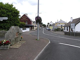
Kinlough is a large village in north County Leitrim. It lies between the Dartry Mountains and the Atlantic Ocean, and between the River Duff and the River Drowes, at the head of Lough Melvin. It borders County Donegal and County Fermanagh, both in Ulster, and is near Yeats Country in County Sligo. It lies 2.5 miles from Bundoran in County Donegal, and across Lough Melvin from the village of Garrison in County Fermanagh.

<span class="mw-page-title-main">Cuilcagh</span> Mountain in Cavan/Fermanagh, Republic of Ireland/Northern Ireland

Cuilcagh is a mountain on the border between County Fermanagh and County Cavan. With a height of 666 metres (2,185 ft) it is the highest point in both counties. It is also the 170th highest peak on the island of Ireland, and Ireland's only cross-border county top. Water from the southern slope flows underground until it emerges some miles away in the Shannon Pot, the traditional source of the River Shannon. The area is sometimes referred to as the Cuilcagh Mountains.

Joe McGowan is an Irish historian, folklorist, and author specialising in the history and heritage of Ireland. He is based in Sligo.

<span class="mw-page-title-main">Dartry Mountains</span> Mountain range in north-west Ireland

The Dartry Mountains are a mountain range in the north west of Ireland, in the north of counties Sligo and Leitrim. They lie between Lough Melvin, Lough Gill and Lough MacNean. The highest point is Truskmore at 647 metres (2,123 ft). Other notable mountains include Benbulbin at 526 metres (1,726 ft), Benwiskin at 514 metres (1,686 ft), and Tievebaun at 611 metres (2,005 ft).

"Under Ben Bulben" is a poem written by Irish poet W. B. Yeats.

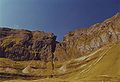
Hanging Rock is a large limestone cliff with an obtuse angle. It is located beside the village of Florencecourt in County Fermanagh, Northern Ireland, and is part of the Cuilcagh mountain region. The cliff is situated in an area dedicated The Hanging Rock Nature Reserve, which is in turn part of the Marble Arch Caves Global Geopark.

<span class="mw-page-title-main">Benaughlin Mountain</span> Mountain in County Fermanagh, Northern Ireland

Benaughlin Mountain, or simply Benaughlin, is a large hill in the Cuilcagh Mountain range in County Fermanagh, Northern Ireland. It rises to 373 metres (1,224 ft) above sea level and is mainly composed of sandstone, limestone and shale. A section of the Ulster Way formerly passed around the side of Benaughlin, within 300 m of the summit until it was revised in 2009 and now instead ascends from Florencecourt.

<span class="mw-page-title-main">Ballaghnatrillick</span> Village in County Sligo, Ireland

Ballaghnatrillick, locally Ballintrillick, is a village in County Sligo, Ireland.

<span class="mw-page-title-main">Duff River</span> River in Counties Leitrim and Sligo, Ireland

The River Duff, or Bunduff, is a river in County Sligo and County Leitrim, Ireland. The River Duff is 14 miles (23 km) long, flowing from Glenade Valley in County Leitrim to the sea. In County Leitrim it is also known as the Black River. It is joined by the Ballanaghtrillick River, which runs out of the Horseshoe Pass.

<span class="mw-page-title-main">Marble Arch Caves Global Geopark</span> Lies on the Fermanagh-Cavan border, Ireland

The Cuilcagh Lakelands Geopark formerly known as the Marble Arch Caves Global Geopark straddles the border between Northern Ireland and the Republic of Ireland. It is centred on the Marble Arch Caves and in 2001 it became one of the first geoparks to be designated in Europe.

<span class="mw-page-title-main">Cliffs of Magho</span>

The Cliffs of Magho are a 9-kilometre-long (5.6 mi) limestone escarpment located in the townland of Magho, County Fermanagh, Northern Ireland. The NNW-facing cliffs overlook the western reaches of Lower Lough Erne and define the northern edge of Lough Navar Forest, a major plantation managed by the Forest Service of Northern Ireland. A popular viewpoint atop the cliffs is accessed by a forest drive.

<span class="mw-page-title-main">Gortarowey Forest Recreation Area</span>

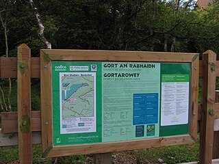
Gortarowey Forest Recreation Area is a forest park and recreation area at the foot of Ben Bulben near Drumcliffe in County Sligo, Ireland. The park is currently managed by Coillte, Ireland's commercial forestry company, as part of the larger Benbulben Forest. The park lies adjacent to the Benbulben, Gleniff and Glenade Special Area of Conservation and is known as the only area in Ireland where chickweed willowherb and alpine saxifrage can be found.

Gortnaleck Court Tomb is a court cairn and National Monument located in County Sligo, Ireland.

The Tyrone Group is a lithostratigraphical term coined to refer to a particular succession of rock strata which occur in Northern Ireland within the Visean Stage of the Carboniferous Period. It comprises a series of limestones, shales and sandstones which accumulated to a thickness of 2400m in the northwest Carboniferous basin of Ireland. The type areas for the group are the Clogher Valley of County Tyrone and the Fermanagh Highlands of nearby County Fermanagh. The rocks of the group sit unconformably on older rocks of the Shanmullagh Formation of the Fintona Group which are the local representatives of the Lower Old Red Sandstone. The top of the Dartry Limestone, the uppermost part of the group, is a disconformity, above which are the layered sandstones and shales of the Meenymore Formation of the Leitrim Group. The succession continues south and west across the border into the Republic of Ireland, though different names are typically applied.

The Leitrim Group is a lithostratigraphical term coined to refer to the succession of rock strata which occur in Northern Ireland within the Visean and Namurian stages of the Carboniferous Period. The group disconformably overlies the Dartry Limestone of the Tyrone Group.

<span class="mw-page-title-main">Ben Lugmore</span> Mountain in County Mayo, Ireland

Ben Lugmore at 803 metres (2,635 ft) is the 29th-highest peak in Ireland on the Arderin scale, and the 37th-highest peak on the Vandeleur-Lynam scale. It is in a horseshoe-shaped massif that includes the slightly higher peak of Mweelrea at 814 metres (2,671 ft), the highest mountain in the Irish province of Connacht. The massif is between Killary Harbour and Doo Lough, in County Mayo.

<span class="mw-page-title-main">Mullaghmore Peninsula</span> Peninsula in County Sligo, Ireland

The Mullaghmore Peninsula, also referred to as Mullaghmore Head, is a small peninsula in the north of County Sligo, Ireland. The coastal village of Mullaghmore is the peninsula's sole settlement. The village has 136 year-round residents according to the 2016 Census; however, its population is significantly higher during summer months. The peninsula is bounded by two large beaches on either side, and sports panoramic views of Ben Bulben and the Dartry Mountains, making it one of Sligo's most popular seaside destinations.

References

  1. Benbulbin. Placenames Database of Ireland.
  2. "The Geological Society Benbulben".
  3. 1 2 "Mountain Views: Benbulbin in area Dartry Mountains" . Retrieved 4 April 2007.
  4. 1 2 3 4 5 Reader's Digest Natural Wonders of the World . The Reader's Digest Association, Inc. 1988. ISBN   0-89577-087-3.
  5. "Yeats Country Drive Sligo" . Retrieved 28 July 2012.
  6. 1 2 3 4 Williams, Mary Anne (2008). Landscapes, Rocks and Fossils: The Geological Heritage of County Sligo: An Action of the County Sligo Heritage Plan. Sligo Regional Technical College. pp. 21, 22. ISBN   978-0955565311.
  7. Marese McDonagh (14 March 2009). "Yeats-link 19th century house could face demolition". The Irish Times . Retrieved 7 February 2010. Sligo Borough Council has confirmed there is a recommendation in the recently published draft Sligo Environs Development Plan that Markievicz House be removed from the list of protected structures. If the elected members vote to delist the building, which in the late 1800s was home to Yeats's maternal grandparents William and Elizabeth Pollexfen, it clears the way for its demolition. [...] Stella Mew, chief executive of the Yeats Society, which is preparing for the 50th International Yeats Summer School this summer, said Sligo's Yeatsian heritage was being "whittled away piece by piece". "Luckily Ben Bulben and Knocknarea are sacrosanct – they cannot delist the mountains or they might be at risk too," she said.
  8. McGarry, James (1976). Place names in the writings of William Butler Yeats . Smythe. p.  21. ISBN   0901072397.
  9. "RootsWeb: IRL-SLIGO-L Climbing Benbulben". Archived from the original on 3 October 2011. Retrieved 10 April 2007.
  10. "Dartry Limestone Formation". British Geological Survey. Retrieved 16 February 2023.
  11. "Benbulben Shale Formation". British Geological Survey. Retrieved 16 February 2023.
  12. Marese McDonagh (7 January 2010). "10-fold increase in AE patients in Sligo". The Irish Times . Retrieved 7 February 2010. These are not people climbing Ben Bulben," he stressed. "This is happening outside people's front doors when they are walking on footpaths or crossing the road.
  13. Lorna Siggins (24 March 2009). "Arrival of the fittest". The Irish Times . Retrieved 7 February 2010. She is said to be looking forward to climbing Ben Bulben again, having already done so several times as a student.
  14. "Léargas". RTÉ . Retrieved 7 February 2010. As he ascends Ben Bulben, he acutely feels the lack of certainty about his right of access to the uplands.
  15. "Benbulben (Gortarowey) Looped Walk". Sligo Walks. Retrieved 15 March 2018.
  16. Edel O'Connell (18 August 2012). "Researchers find first hardy Irish plant that beat Ice Age". Irish Independent . Retrieved 5 September 2012.
  17. 1 2 3 4 Conner, L.I. (1998). A Yeats Dictionary: Persons and Places in the Poetry of William Butler Yeats. Irish studies. Syracuse University Press. p. 14. ISBN   978-0-8156-2770-8.
  18. Bright, Michael (2005). 1001 Natural Wonders You Must See Before You Die. Quintet Publishing Limited. ISBN   0-7641-5817-1.
  19. Sligo: Benbulbin "The Noble Six Cross"© Copyright Michael Murtagh and licensed for reuse under this Creative Commons Licence. Retrieved 3 June 2012.
  20. 1 2 "Another link in the Ben Bulben story". The Mayo News. 4 May 2006. Retrieved 7 February 2010.
  21. 1 2 3 Burke, Dennis P. "Boeing B-17G Flying Fortress, Sligo, December 1943" . Retrieved 4 October 2020.
  22. Joe McGowan (2003). "The Donegal corridor and the Battle of the Atlantic". History Ireland. Retrieved 5 September 2012.
  23. Kim Bielenberg (11 July 2009). "The day death came from a clear blue sky". Irish Independent . Retrieved 7 February 2010.
  24. Valerie Shanley (23 August 2009). "The shadow of Mullaghmore". Sunday Tribune . Archived from the original on 9 September 2010. Retrieved 7 February 2010.
  25. Rónán Duffy (18 May 2018). "Pro-life group says the 'No' on Ben Bulben was 'vandalised' and removed". TheJournal.ie . Retrieved 18 June 2022.
  26. "Athletics: Cullen back on track after year from hell". Irish Independent . 5 December 2009. Retrieved 7 February 2010. She's from picturesque Drumcliffe, in the heart of Yeats country, surrounded by idyllic sea, sands and Benbulbin but, ironically, the weather has been unseasonably foul and her preparations epitomise the loneliness of the long-distance runner.
  27. Anita Guidera (22 September 2009). "Hills alive as 17-year walker row resolved". Irish Independent . Retrieved 7 February 2010.
  28. 1 2 Anita Guidera (29 January 2009). "Poetry fans tread softly on trail of Yeats's most beloved haunts". Irish Independent . Retrieved 7 February 2010.
  29. Christopher Somerville (7 November 2009). "Walk of the week: The Rosses Co Sligo". Irish Independent . Retrieved 7 February 2010.
  30. 1 2 Joe Joyce (18 September 1948). "WB Yeats laid to rest in Drumcliffe". The Irish Times . Archived from the original on 18 October 2012. Retrieved 7 February 2010. The scene at Drumcliffe was set by Yeats himself. In his last poem, published in The Irish Times, he wrote: Under bare Ben Bulben's head / In Drumcliffe Churchyard Yeats is laid . . .
  31. Orla Tinsley (18 July 1948). "Irish coasting". The Irish Times . Retrieved 7 February 2010. After a quick leg-stretch in Mullaghmore we travel past the looming presence of Ben Bulben on our way to Yeats's grave at Drumcliff.

Yeats