The Twelve Bens or Twelve Pins, also called the Benna Beola, is a mountain range of mostly sharp-peaked quartzite summits and ridges in the Connemara National Park in County Galway, in the west of Ireland. The widest definition of the range includes the Garraun Complex to the north as well as several isolated peaks to the west, and is designated a 16,163-hectare (39,940-acre) Special Area of Conservation.

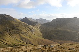
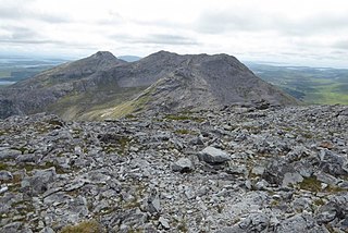
Bencorr at 711 metres (2,333 ft), is the 82nd–highest peak in Ireland on the Arderin scale, and the 102nd–highest peak on the Vandeleur-Lynam scale. Bencorr is situated near the centre of the core massif of the Twelve Bens mountain range in the Connemara National Park in Galway, Ireland. It is the second-tallest mountain of the Twelve Bens range, after Benbaun 729 metres (2,392 ft); it lies close to Benbaun, separated only by the third-highest mountain in the range of Bencollaghduff 696 metres (2,283 ft), and the col of Maumina.

Letterbreckaun is one of the Maumturk Mountains of Connemara in County Galway, Ireland. At 677 metres (2,221 ft), it is the second-tallest of the Maumturks, the 129th–highest peak in Ireland on the Arderin list, and 159th–highest on the Vandeleur-Lynam list. Letterbreckaun is in the middle sector of the long north-west to south-east spine of the Maumturks.

Binn Chaonaigh is one of the Maumturk Mountains of Connemara in County Galway, Ireland. At 633 metres (2,077 ft), it is the fourth-highest of the Maumturks, the 185th-highest peak in Ireland on the Arderin list, and the 223rd-highest on the Vandeleur-Lynam list. It is in the middle sector of the long north-west to south-east spine of the Maumturks.

Garraun at 598 metres (1,962 ft), is the 224th–highest peak in Ireland on the Arderin scale, however, while it is just short of the elevation threshold of 600-metres for other classifications, it does have the prominence to be a Marilyn. Garraun lies on an isolated massif near the mouth of Killary Harbour at the far north sector of the Twelve Bens/Garraun Complex Special Area of Conservation in the Connemara National Park in Galway. The southern slopes are a scenic backdrop to Kylemore Abbey and Kylemore Lough.

Diamond Hill or Bengooria is an isolated peak overlooking the village of Letterfrack, in the northwest corner of the Twelve Bens in Connemara National Park in County Galway, Ireland. At only 442 metres (1,450 ft), it does not rank as an Arderin, or a Vandeleur-Lynam; however, it has the prominence to rank as a Marilyn.
Bencollaghduff at 696 metres (2,283 ft), is the 93rd–highest peak in Ireland on the Arderin scale, and the 115th–highest peak on the Vandeleur-Lynam scale. Bencollaghduff is situated near the centre of the core massif of the Twelve Bens mountain range in the Connemara National Park in Galway, Ireland. It is the 3rd tallest mountain of the Twelve Bens range, after Benbaun 729 metres (2,392 ft), to which it is connected by the northern col of Maumina; and after Bencorr 711 metres (2,333 ft), to which it is connected by a high southeast rocky ridge.
Lough Inagh is a freshwater lake in the Inagh Valley, in Connemara, Galway, in the west of Ireland.

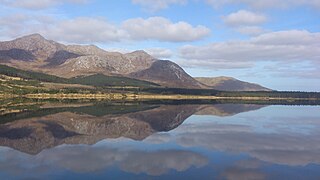
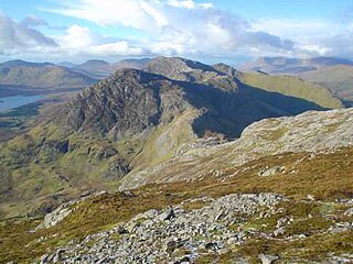
Derryclare Lough is a freshwater lake at the entrance of the Inagh Valley, in Connemara, Galway, in the west of Ireland.
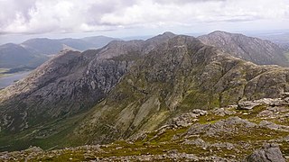
Benbreen at 691 metres (2,267 ft), is the 100th–highest peak in Ireland on the Arderin scale, and the 122nd–highest peak on the Vandeleur-Lynam scale. Benbreen lies in the southern end of the Twelve Bens mountain range in the Connemara National Park in Galway, Ireland. Benbreen is the 4th-tallest mountain of the Twelve Bens range, after Benbaun 729 metres (2,392 ft), Bencorr 711 metres (2,333 ft), and Bencollaghduff 696 metres (2,283 ft). Benbreen's profile is of a "high narrow rocky ridge with several summits", than a typical "peaked mountain".

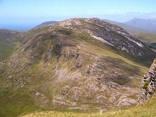
Bengower at 664 metres (2,178 ft), is the 135th–highest peak in Ireland on the Arderin scale, and the 166th–highest peak on the Vandeleur-Lynam scale. Bengower is in the southern end of the Twelve Bens mountain range in the Connemara National Park in Galway, Ireland, and is the 6th-tallest of the core Twelve Bens.

Derryclare is a mountain at the southern edge of Twelve Bens mountain range in Connemara National Park in County Galway, Ireland. At 677 metres (2,221 ft), it is the 119th–highest peak in Ireland on the Arderin list, and the 145th–highest peak on the Vandeleur-Lynam list. It is the 5th tallest of the core Twelve Bens. The Derryclare Lough on its southern slopes is a scenic location in Connemara, while Derryclare Wood, on its eastern slopes, contains a Statutory Nature Reserve (SRN).
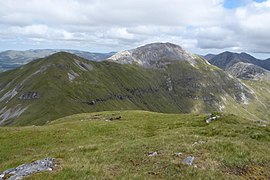
Knocknahillion is one of the Maumturk Mountains of Connemara in County Galway, Ireland. At 607 metres (1,991 ft), it is the 210th–highest peak in Ireland on the Arderin list, and 256th–highest on the Vandeleur-Lynam list. Knocknahillion is in the middle sector of the long north-west to south-east spine of the Maumturks. The summit is offset to the west of the rocky central ridge of the Maumturks, and its western-facing slopes have a distinctive "diagonal" rock stratification when viewed from the Inagh Valley.
Benbrack at 582 metres (1,909 ft), is the 251st–highest peak in Ireland on the Arderin scale; while it does not have the elevation to be a Vandeleur-Lynam, it has the prominence to rank as a Marilyn. Benbrack is situated on its own small massif to the north of the core Twelve Bens mountain range in the Connemara National Park in Galway, Ireland. It is the 10th-tallest of the core Twelve Bens, and is linked by a deep col to Muckanaght, which is itself attached by a high ridge to the tallest mountain of the Twelve Bens range, Benbaun at 729 metres (2,392 ft).

Benlettery at 557 metres (1,827 ft), is the 259th–highest peak in Ireland on the Arderin scale. Benlettery is in the southernmost peak of the Twelve Bens mountain range in the Connemara National Park in Galway, Ireland, and is the 11th-tallest of the core Twelve Bens. The Ben Lettery An Oige youth hostel is on the southern slopes of Benlettery, off the N59 road to Clifden.

Benglenisky at 516 metres (1,693 ft), is the 368th–highest peak in Ireland on the Arderin scale. Benglenisky is the second most southern peak, after neighbouring Benlettery, of the Twelve Bens mountain range in the Connemara National Park in Galway, Ireland, and is the lowest of the core Twelve Bens.

Mullach Glas is one of the Maumturk Mountains of Connemara in County Galway, Ireland. At 622 metres (2,041 ft), it is the fifth-highest of the Maumturks, the 197th–highest peak in Ireland on the Arderin list, and 238th–highest on the Vandeleur-Lynam list. Mullach Glas is on a massif that includes Binn Mhór and Corcogemore ; this massif is at the far southeastern sector of the long north-west to south-east spine of the Maumturks.

Leenaun Hill at 618 metres (2,028 ft), is the 201st–highest peak in Ireland on the Arderin scale, and the 243rd–highest peak on the Vandeleur-Lynam scale. Leenaun Hill lies on a massif that overlooks Leenaun village and Killary Harbour, and which is at the far northeastern sector of the Maumturks mountain range in the Connemara National Park in Galway, Ireland; this massif is connected to the main range via the "Col of Despondency". Leenaun Hill is the 6th-highest mountain in the Maumturks, and its grassy massif, constructed from sandstone and siltstone, contrasts with the rocky ridges and summits constructed from quartzites, grits, and graphitic, of the middle and southern sectors of the range.

Lissoughter at 401 metres (1,316 ft), does not qualify to be an Arderin or a Vandeleur-Lynam, however, its prominence of 336 metres (1,102 ft) ranks it as a Marilyn. Lissoughter is an isolated peak, situated between the Twelve Bens and Maumturks mountain ranges, at the southern entrance to the Inagh Valley, in the Connemara National Park, in Recess, County Galway, Ireland.

Ben Lugmore at 803 metres (2,635 ft) is the 29th-highest peak in Ireland on the Arderin scale, and the 37th-highest peak on the Vandeleur-Lynam scale. It is in a horseshoe-shaped massif that includes the slightly higher peak of Mweelrea at 814 metres (2,671 ft), the highest mountain in the Irish province of Connacht. The massif is between Killary Harbour and Doo Lough, in Mayo.