Errit Lough

Last updated

Errit Lough
Loch Eirid (Irish)
Island of Ireland relief location map.png
Red pog.svg
Location in Ireland
Location County Roscommon
Coordinates 53°48′48″N8°42′12″W / 53.81333°N 8.70333°W / 53.81333; -8.70333
Primary outflows River Lung
Catchment area 7.15 km2 (2.8 sq mi)
Basin  countries Ireland
Max. length1.25 km (0.8 mi)
Max. width0.7 km (0.4 mi)
Surface area0.82 km2 (0.32 sq mi)
Surface elevation83 m (272 ft)
References [1] [2]

Errit Lough (Irish : Loch Eirid) [3] is a freshwater lake in the west of Ireland. It is located in west County Roscommon in the catchment of the Boyle River. The lake is a Natura 2000 site. It is protected as a Special Area of Conservation (or SAC) since May 2016 under the qualification of a specific habitat type: the presence of ‘Hard Water Lakes’, alternatively known as ‘Hard oligo-mesotrophic waters with benthic vegetation of Chara spp.’ [4] [5] [6] [7]

Contents

Location

Errit Lough is located approximately 10 km south-west of the town of Ballaghaderreen in County Roscommon. The lake is situated in the upper part of the Boyle River catchment. The area of Errit Lough included in the SAC designation is located in the townlands of Cloondart, Derreenamackaun, Errit, Gortaganny (Electoral District Artagh South) and Tully (Electoral District Artagh South) in County Roscommon. Schedule 1 of the Statutory Instrument for this site identifies it as encompassing an area of 84.59 ha. [4] [5]

Photo of Lough Errit, a hard water lake and SAC Lough Errit, County Roscommon.jpg
Photo of Lough Errit, a hard water lake and SAC

SAC qualification

The Errit Lough site was proposed as a Site of Community Importance (SCI) in 1998. [6] In 2016, the site as designated as a Special Area of Conservation, with site code IE0000607. Statutory Instrument 266 of 2016 established the site as an SAC. [4] The feature which qualifies this site for SAC status is the presence of Hard Water Lakes – this habitat is also known as ‘‘Hard oligo-mesotrophic waters with benthic vegetation of Chara spp.’. Under the EU Habitats Directive, this is an Annex I habitat type (code 3140). The Interpretation Manual of European Union Habitats defines this habitat as comprising:

“Lakes and pools with waters fairly rich in dissolved bases (pH often 6-7) (Pal. 22.12) or with mostly blue to greenish, very clear, waters poor (to moderate) in nutrients, base-rich (pH often >7.5) (Pal. 22.15). The bottom of these unpolluted water bodies are covered with charophyte, Chara and Nitella, algal carpets. In the Boreal region this habitat type includes small calcareous-rich oligo-mesotrophic gyttja pools with dense Chara (dominating species is Chara strigosa) carpets, often surrounded by various eutrophic fens and pine bogs.” [8]

Hard water lakes are typically base-rich, oligotrophic and unpolluted, with clear water. The NPWS publication "Benthic vegetation in Irish marl lakes: monitoring habitat 3140 condition 2011 to 2018" notes that the alkalinity of this lake was 136 mg/l CaCO3 and the euphotic depth (a measure of water clarity: the depth at which photosynthetic available radiation is 1% of its surface value) was 3.3 m. Typically lakes with total phosphorus of less than 0.01 mg/l have euphotic depth of over 5.0 m, but Lough Errit, a high-colour lake (of over 45 Hazen units), has low levels of phosphorus (total phosphorus of approximately 0.01 mg/l) and a low euphotic depth. This document notes four Charophyte species occurring in this lake, with charophyte cover of 0.52 (52%). It is noted that in Ireland, marl lakes and cut-over bogs often occur in the same location, an issue for this habitat type is the leaching of coloured water into these lakes, resulting in a high water colour. This may explain the low levels of deeper water vegetation in Errit Lough. [9]

Erit Lough, a hard water lake and SAC Errit Lough, County Roscommon.jpg
Erit Lough, a hard water lake and SAC

Vegetation

The east side of this marl lake has exposed stony shores. On the west side of the lake are more sheltered areas. Within these more protected bays can be found emergent species such as Common Club-rush (Scirpus lacustris or Schoenoplectus lacustris) and Common Reed (Phragmites australis). Bottle Sedge (Carex rostrata) and Common Spike-rush (Eleocharis palustris) also occur on the west side of the site. [5]

As part of the designation criteria for the site (Hard Water lake with Chara Spp), there are beds of stonewort species (Chara spp) growing on the lake bed. These species include Chara pedunculata, C. rudis, C. desmacantha and C. fragilis. In certain areas of the lake, floating Yellow water-lily (Nuphar lutea) are recorded.

Nearby Special Areas of Conservation and proposed Natural Heritage Areas

As can be seen from the National Parks and Wildlife Service (NPWS) designated sites map, other designated SAC sites nearby include Urlaur Lough (NPWS site code 001571), Derrinea bog (NPWS site code 000604), Carrowbehy/Caher Bog (NPWS site code 000597), Drumalough Bog (NPWS site code 002338), and the River Moy SAC (NPWS site code 002298). This concentration of designated SACs in the area indicates that this location is ecologically very valuable. [10] The Errit Lough site has been included as a proposed Natural Heritage Area (or pNHA) by the National Parks and Wildlife Service (NPWS). Other nearby pNHA sites include Urlaur Lough, Carrowbehy/Caher Bog, Derrinea Bog, Mannin And Island Lakes, Drumalough Bog and Lough Glinn. [10]

Other features

Geology

The area surrounding the lake is a County Geological Site (or CGS). This area comprises the Erris and Cloonagh Loughs Deltas (site code RO012). The deltas are wide, flat-topped ridges of gravel and sand, situated above the nearby bog area. The deltas are considered to be good examples of deglacial, ice-marginal, meltwater-deposited features which frequently form at the edge of glacial lakes. The deltas were deposited at this site during deglaciation after the last Ice Age, at the edge of the northwestward-retreating ice sheet and date from the Quaternary period. These deltas were formed on Lower Carboniferous limestone bedrock and are made up of limestone clasts, which came from the bedrock around the site. The ice carried them until they were released into a meltwater conduit within the ice. They were then deposited at the margin of the ice sub-aqueously at the point where the river left the ice, flowing in a southeastward direction. [11] [12]

Archaeology

The Historic Environment Viewer map of Irish recorded monuments includes a number of historic features at Errit Lough. A number of crannógs have been recorded from the lake (site codes RO019-004, RO019-005, RO109-009 and RO019-011). From the recorded monuments records, site code RO019-010 refers to a well (with no evidence that it is a holy well) known as Tober Skeheen, which has a pump-house. Site RO019-006 refers to a circular embanked enclosure with external diameter of approximately 35 metres, which was noted on the 1837 Irish Ordnance Survey maps. It is suggested from these records that this may have been a rath. Site RO019-008 refers to a souterrain sited on the crest of a low north-south ridge south-west of the lake. The precise location is unknown and the information about it comes from local knowledge. Site RO019-012 to the east of the lake refers to a children’s burial ground. [13]

Walking trails

There is a walking trail around Errit Lough – the Lough Errit Walking Trail – which includes a range of looped walks (difficulty rating: Easy) of between 4 and 11 km in length. Dogs on leads are allowed but the walks are not buggy-accessible. [14]

Conservation objectives

The primary conservation objective for the site is to “maintain the favourable conservation condition of Hard oligo-mesotrophic waters with benthic vegetation of Chara spp. in Errit Lough SAC”. [15] This includes objectives to maintain the habitat area /extent subject to natural processes, to prevent decline of the habitat distribution, to prevent decline of the lake vegetation composition, zonation and depth, and to maintain the hydrological regime (groundwater flows) in order to support the habitat. The water quality should be maintained with low (oligotrophic) nutrient concentrations, high transparency, high chlorophyll, phytoplankton and algal biomass status. [15]

See also

Related Research Articles

<span class="mw-page-title-main">Turlough (lake)</span> Type of seasonal or periodic lake found in limestone areas of Ireland

A turlough is a seasonal or periodic water body found mostly in limestone karst areas of Ireland, west of the River Shannon. The name comes from the Irish tur, meaning "dry", and loch, meaning "lake". The water bodies fill and empty with the changes in the level of the water table, usually being very low or empty during summer and autumn and full in the winter. As groundwater levels drop the water drains away underground through cracks in the karstic limestone.

<span class="mw-page-title-main">Lough Derravaragh</span> Lake in County Westmeath, Ireland

Lough Derravaragh is a lake in County Westmeath, Ireland, north of Mullingar between Castlepollard, Crookedwood and Multyfarnham.

<span class="mw-page-title-main">Lough Lene</span> Lake in north County Westmeath, Ireland

Lough Lene is a lake situated in north County Westmeath, Ireland, between the villages of Castlepollard, Collinstown and Fore.

<span class="mw-page-title-main">Lough Oughter</span> Lake in County Cavan, Ireland

Lough Oughter is a lake, or complex of lakes, in County Cavan covering more than 8,900 hectares. The complex of lakes lies on the River Erne, and forms the southern part of the Lough Erne complex. The lakes are bounded roughly by Belturbet in the north, Cavan town to the east, Crossdoney to the south and Killeshandra to the west.

<span class="mw-page-title-main">Lough Bane</span> Lake in Counties Meath and Westmeath, Ireland

Lough Bane is a lake on the border of County Meath and County Westmeath in Ireland. The county border runs east–west through the centre of the lake.

<i>Chara</i> (alga) Genus of green algae

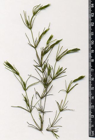
Chara is a genus of charophyte green algae in the family Characeae. They are multicellular and superficially resemble land plants because of stem-like and leaf-like structures. They are found in freshwater, particularly in limestone areas throughout the northern temperate zone, where they grow submerged, attached to the muddy bottom. They prefer less oxygenated and hard water and are not found in waters where mosquito larvae are present. They are covered with calcium carbonate (CaCO3) deposits and are commonly known as stoneworts. Cyanobacteria have been found growing as epiphytes on the surfaces of Chara, where they may be involved in fixing nitrogen, which is important to plant nutrition.

<span class="mw-page-title-main">Lough Yganavan and Lough Nambrackdarrig</span> Lakes in County Kerry, Ireland

Lough Yganavan and Lough Nambrackdarrig are two lakes of ecological importance in County Kerry, Ireland. In 1988, Lough Nambrackdarrig and the southern half of Lough Yganavan were designated as National Nature Reserves. Since 1998, the lakes have been included in a Special Area of Conservation (SAC) of 271.6 hectares (3 km2), which protects land in private ownership and the two state-owned nature reserves. The habitats in the SAC include fixed dunes, a type of machair.

Kylecorragh Wood is an old oak woodland along the freshwater stretches of the River Nore in County Kilkenny, Ireland. Located 5 kilometres (3.1 mi) west of New Ross, it consists of 100 acres (400,000 m2). Kylecorragh Woods are of regional importance as an relatively undisturbed example of the original deciduous woodland which covered the river valley.

<span class="mw-page-title-main">Shannon Callows</span> Low lying areas between Athlone and Portumna, Ireland

The Shannon Callows are areas of flat land along the shores of the River Shannon. These areas lie between Athlone in County Westmeath, where the river flows out of Lough Ree, and Portumna in County Galway, where it enters Lough Derg, in central Ireland. The shallow grade of the river here results in occasional flooding of the Callows.

Scohaboy Bog is a raised bog in County Tipperary in Ireland. It lies approximately 6 km northwest of Cloughjordan, County Tipperary, between the N52 and R490 roads.

<span class="mw-page-title-main">Lough Arrow</span>

Lough Arrow is a freshwater lake in the northwest of Ireland. This large, scenic lake covers an area of 12.47 square kilometres (4.8 sq mi) and lies mostly in County Sligo with a smaller part in County Roscommon. It is a popular trout fishing lake.

<span class="mw-page-title-main">Lough Funshinagh</span> Ecological site in County Roscommon, Ireland

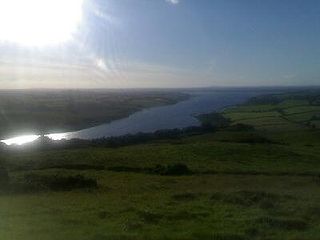
Lough Funshinagh is a lake and Special Area of Conservation in County Roscommon, Ireland, found to the west of Lough Ree. It has been called Ireland's amazing disappearing lake, due to the way it empties quickly - in as little as two days - and unpredictably, sometimes killing thousands of fish. Lough Funshinagh is one of a number of seasonal lakes, or turlough, found in the karst areas of Ireland, west of the River Shannon.

Annaghmore Lough is a freshwater lake in the west of Ireland. It is located in County Roscommon in the catchment of the upper River Shannon.

<span class="mw-page-title-main">Ballynafagh Lake</span> Lake in County Kildare, Ireland

Ballynafagh Lake is a shallow alkaline lake, located approximately 2 km (1.2 mi) north-west of the village of Prosperous in County Kildare, Ireland. It is designated as a special area of conservation (SAC) and protected under European Union and Irish legislation. It is one of the European protected nature sites that comprise the Natura 2000 network. It is a short distance north of the Ballynafagh Bog.

<span class="mw-page-title-main">Rye Water Valley / Carton</span> Ecological site in County Kildare, Ireland

The Rye Water Valley/Carton Special Area of Conservation or SAC is a Natura 2000 site based along the Rye Water / River Rye in north County Kildare, Ireland. It is protected as an SAC since November 2018 due to the presence of a rare hydrogeological habitat at a site close to the River Rye, and the presence of protected species.

The Mouds Bog Special Area of Conservation or SAC is a Natura 2000 site based close to the Hill of Allen and to Newbridge, County Kildare, Ireland. The qualifying interests by which it is protected as an SAC are the presence of three habitat types: the presence of active raised bogs, the presence of degraded raised bogs still capable of natural regeneration, and the presence of depressions on peat substrates of Rhynchosporion vegetation.

The Red Bog Special Area of Conservation or SAC is a Natura 2000 site in County Kildare, close to the town of Blessington in County Wicklow, Ireland. The qualifying interests by which it is protected as an SAC are the presence of a specific habitat type: transitional mires and quaking bogs.

The Carrigeenamronety Hill Special Area of Conservation or SAC is a Natura 2000 site in the Ballyhoura Mountains, Ireland. The qualifying interests for which it is protected as an SAC are the presence of the Killarney fern and the presence of a dry heath habitat.

The Ballynafagh Bog Special Area of Conservation or SAC is a Natura 2000 site in County Kildare, close to the town of Prosperous in County Kildare, Ireland. The three qualifying interests by which this site is protected as an SAC are the presence of active raised bog, of degraded raised bogs still capable of natural regeneration, and of depressions on peat substrates of the Rhynchosporion.

The Four Roads Turlough Special Area of Conservation is a Natura 2000 site based at the village of Four Roads, Ireland, close to Roscommon town, in County Roscommon, Ireland. The Four Roads Turlough is one of a number of seasonal lakes, or turloughs, found in the karst areas of Ireland, west of the River Shannon.

References

  1. Google (1 March 2016). "Errit Lough" (Map). Google Maps . Google. Retrieved 1 March 2016.
  2. Free, Gary; Little, Ruth; Tierney, Deirdre; Donnelly, Karol & Caroni, Rossana (2006). A Reference Based Typology and Ecological Assessment System for Irish Lakes (PDF) (Report). Environmental Protection Agency (Ireland). p. 11. Retrieved 11 October 2022.
  3. "Loch Eirid/Errit Lough". Placenames Database of Ireland (logainm.ie). Government of Ireland - Department of Arts, Heritage and the Gaeltacht and Dublin City University . Retrieved 30 January 2020.
  4. 1 2 3 "Statutory Instrument S.I. No. 266/2016 - European Union Habitats (Errit Lough Special Area of Conservation 000607) Regulations 2016". irishstatutebook.ie/. Archived from the original on 26 May 2024. Retrieved 26 May 2024.
  5. 1 2 3 "NPWS Errit Lough Site Synopsis" (PDF). npws.ie. Archived (PDF) from the original on 26 May 2024. Retrieved 26 May 2024.
  6. 1 2 "EUNIS-Errit Lough SAC". eunis.eea.europa.eu. Archived from the original on 26 May 2024. Retrieved 26 May 2024.
  7. "Errit Lough Biodiversity Information System for Europe". biodiversity.europa.eu/. Archived from the original on 29 May 2024. Retrieved 29 May 2024.
  8. "EUNIS Habitat type: Hard oligo-mesotrophic waters with benthic vegetation of Chara spp". eunis.eea.europa.eu. Archived from the original on 26 May 2024. Retrieved 26 May 2024.
  9. Roden, Cilian; Murphy, Paul; Ryan, James. "Benthic vegetation in Irish marl lakes: monitoring habitat 3140 condition 2011 to 2018" (PDF). npws.ie/. Archived (PDF) from the original on 29 May 2024. Retrieved 29 May 2024.{{cite web}}: CS1 maint: multiple names: authors list (link)
  10. 1 2 "NPWS Designations Viewer". dahg.maps.arcgis.com. Retrieved 28 May 2024.
  11. "County Geological Site Report" (PDF). gsi.geodata.gov.ie/. Archived (PDF) from the original on 28 May 2024. Retrieved 28 May 2024.
  12. "Department of the Environment, Climate & Communications Public Data Viewer". dcenr.maps.arcgis.com/home/index.html. Retrieved 28 May 2024.
  13. "National Monuments Service Historic Environment Viewer". heritagedata.maps.arcgis.com. Retrieved 29 May 2024.
  14. "Lough Errit Walking Trail". visitroscommon.ie. Archived from the original on 28 May 2024. Retrieved 28 May 2024.
  15. 1 2 "NPWS Errit Lough Conservation Objectives" (PDF). npws.ie. Archived from the original on 28 May 2024. Retrieved 28 May 2024.