Little Brosna River

Last updated

Little Brosna
Riverstown Bridge - geograph.org.uk - 1254015.jpg
Little Brosna River at Riverstown
EtymologyPossibly means "place of twigs" [1]
Native nameAn Bhrosnach Bheag (Irish)
Location
CountryIreland
Physical characteristics
Source 
  locationNear Dunkerrin, County Offaly
Mouth  
  location
Atlantic via the River Shannon
Length57.6 kilometres (35.8 mi)
Basin size662 km2 (256 sq mi)
Discharge 
  average8.062 m3/s (284.7 cu ft/s) [2]
Basin features
River system Shannon
Tributaries 
  left Camcor River

The Little Brosna River (Irish : An Bhrosnach Bheag) [3] rises near Dunkerrin, County Offaly, Ireland. It flows for 36 miles [4] before joining the River Shannon. [5]

Contents

Course

The river rises near Dunkerrin, and flows near Birr; it forms part of the boundary between County Offaly and County Tipperary. [6] It crosses an area of limestone, then passes through an area of callow before merging with the easternmost of four channels of the Shannon near Victoria Lock, by Clonahenoge and facing Meelick. [7]

Tributaries

The most significant tributary is the River Camcor at Birr, while others include the Pallas Stream, Bunow River, Clareen Stream, Golden Grove Stream and Keeloge Stream. [7]

Bridges

Sharavogue Bridge, built in the early 1850s, carries the R492 road over the river which here forms the boundary between the townlands of Sharavogue and Ballincor Demesne. The bridge is listed as being of architectural and technical interest. [8]

Railway Bridge at Glasderry More is a latticed metal bridge carrying the (disused) railway line over the Little Brosna. [9]

Riverstown Bridge, with five arches, carries the N52 across the Little Brosna near Riverstown. This is a narrow bridge at 5.15m between parapets, with traffic negotiating the bridge one direction at a time with the aid of traffic lights. [9]

Croghan Bridge a stone bridge of three arches from the mid-18th century, it carries the Croghan Road, Birr across the Little Brosna. [10]

Ivy Bridge crosses the river within the demesne of Birr Castle, just downstream of the confluence of the rivers Camcor and Little Brosna. [11]

Derrinsallow Bridge, built about 1850, has three arches of dressed limestone and rubble. It crosses from County Offaly to County Tipperary at Derrinsallow. [12]

New Bridge built about 1820 is the last crossing before joining the Shannon. It has five rounded arches of limestone. The bridge takes the R438 road between County Tipperary and County Offaly. [13]

Angling

The Little Brosna is a historic and popular angling river, particularly known for its brown trout. [14] An electric fishing survey of the river at Riverstown was conducted in September 2012 by Inland Fisheries Ireland. Species noted here were brown trout (87), lamprey (1), salmon (38) and stone loach (7). [15]

Some good Fishing can be had around Shinrone and Birr during the months of late spring and early Summer. Dry Fly Fishing is the preferred method used by anglers To catch Trout on the river. In some cases, Spinning can be used to catch some of the bigger brown trout

Inland fisheries Ireland operate a Fish Farm Outside Shinrone, near Brosna. Rainbow & Brown trout are bred in the Farm. The Fish farm is located on the River.

Drainage

The Little Brosna Water Management Unit Action Plan [16] covers 681km2 in County Offaly, North Tipperary and County Laois.

Sharavogue Bog is a raised bog situated on the flood plain of the Little Brosna at Sharavogue in County Offaly. It is an example of a type of habitat that is becoming increasingly rare in Ireland and Europe and is on the list of Special Areas of Conservation, as listed by the National Parks and Wildlife Service. [17] [18] [19]

Redwood raised bog, named for Redwood, North Tipperary, has developed on the southern margin of the Little Brosna flood plain at its confluence with the Shannon. It forms part of the Little Brosna Callows Area of Scientific Interest, which is of international importance as a wildfowl habitat and as a classical example of a flood plain ecosystem. The reserve includes the last relatively intact bog dome on the flood plain margin as well as a dried out portion of another dome and an area of fen. The intact dome has a typical raised bog flora and in the centre it retains quaking areas and numerous bog pools. Established in 1991 it is in state ownership. [20]

See also

Related Research Articles

<span class="mw-page-title-main">County Offaly</span> County in Ireland

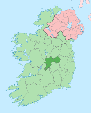
County Offaly is a county in Ireland. It is part of the Eastern and Midland Region and the province of Leinster. It is named after the ancient Kingdom of Uí Failghe. It was formerly known as King's County, in honour of Philip II of Spain. Offaly County Council is the local authority for the county. The county population was 82,668 at the 2022 census.

<span class="mw-page-title-main">Birr Castle</span> 17th-century castle with demesne, telescopes and science museum

Birr Castle is a large castle in the town of Birr in County Offaly, Ireland. It is the home of the 7th Earl of Rosse and his family, and as such the residential areas of the castle are not open to the public, though the grounds and gardens of the demesne are publicly accessible, and include a science museum and a café, a reflecting telescope which was the largest in the world for decades and a modern radio telescope.

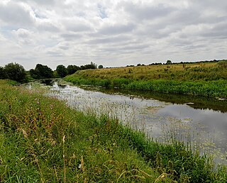
The River Camcor is a tributary of the Little Brosna River in central Ireland. It joins the Little Brosna in the Birr Castle Desmesne, Birr, County Offaly. The Little Brosna, in turn, joins the River Shannon close to Victoria Lock at Meelick.

<span class="mw-page-title-main">Riverstown (near Birr)</span> Village in Munster, Ireland

Riverstown is a small village straddling the border between Counties Tipperary and Offaly on the outskirts of Birr in Ireland. It is mostly within the townland of Ballyloughnane, on the Tipperary side of the river.

<span class="mw-page-title-main">Shinrone</span> Village in Leinster, Ireland

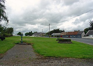
Shinrone is a village in County Offaly, Ireland. It is in the southernmost part of the county, close to the border with County Tipperary. It lies at the junction of the R491 regional road between Nenagh and Roscrea with the R492 to Sharavogue. At the 2016 census, the village population was 645.

<span class="mw-page-title-main">Brosna, County Offaly</span> Village in Leinster, Ireland

Brosna is a small village and townland in County Offaly, Ireland. It lies in the valley of the Little Brosna River less than one kilometer off the N62 national secondary road. As of the 2011 census, Brosna townland had a population of 31 people. The area takes its named from the Little Brosna River, which flows through the townland.

Rathcabbin often Rathcabban is a small village and an electoral district situated at the very north of County Tipperary in Ireland. The village is located off the R489 regional road between Portumna, County Galway and Birr, County Offaly. It is 5 km east of the River Shannon and Lough Derg.

<span class="mw-page-title-main">Dunkerrin</span> Village in Leinster, Ireland

Dunkerrin is a small village in County Offaly, Ireland, just south of Roscrea and near the County Tipperary border. It on the R445 road which was once the main road from Dublin to Limerick. Dunkerrin is now bypassed by the M7, the nearest access is junction 23 at Moneygall.

The Ballyfinboy River rises close to Moneygall in County Offaly, Ireland and flows in a generally northwesterly direction into Lough Derg at Drominagh. It forms part of the boundary between County Tipperary and County Offaly. The river flows through the towns of Cloughjordan and Borrisokane west of which it flows past Ballyfinboy Castle, a ruined tower house with a Sheela na gig in the townland of Ballyfinboy.

Derrinsallow is a townland in the historical Barony of Ormond Lower, County Tipperary, Ireland. It is located North-West of Birr on the south-west bank of the Little Brosna River within the civil parish of Dorrha. The Little Brosna River provided power to the 19th century corn mills at Derrinsallow which although now in ruins are mentioned in the National Inventory of Architectural Heritage. The mill race is a popular fishing area. A triple arched limestone bridge from the 19th century crosses the river here.

<span class="mw-page-title-main">Victoria Lock (River Shannon)</span>

Victoria Lock, also known as Meelick Lock, is the first lock on the River Shannon upstream of Lough Derg, it is situated between Meelick, County Galway and Clonahenoge, County Offaly where the Little Brosna River enters the Shannon. It is very near the tripoint where the provinces of Munster, Leinster and Connacht meet. The lock is of architectural and technical interest and is listed on the Nation Inventory of Architectural Heritage, the dimensions are 142 ft x 40 ft. Thomas Rhodes on the instructions of the Shannon Commissioners constructed the lock in the 1840s as part of a widescale upgrade of the Shannon Navigation. The lock is still in use today by pleasure craft, both private and fleets of rental cruisers who use the River Shannon and the connecting canals. A second lock, Hamilton Lock is also located nearby but is now disused.

<span class="mw-page-title-main">Carrig (electoral division)</span>

Carrig is a settlement and electoral district in the historical Barony of Ormond Lower, County Tipperary, Ireland. It is located on the N52 road between Birr and Borrisokane. The early medieval Christian psalter known as the Faddan More Psalter was discovered near here in July 2006 in a peat bog.

Clonahenoge is a townland in County Offaly, Ireland. It is located at the confluence of the Little Brosna River and the River Shannon.

<span class="mw-page-title-main">Nenagh River</span> Tributary of the Shannon in County Tipperary, Ireland

The Nenagh River rises in the Silvermine Mountains in County Tipperary, Ireland. It flows east of Nenagh and into Lough Derg just north of Dromineer.

<span class="mw-page-title-main">R492 road (Ireland)</span> Road in County Offaly, Ireland

The R492 is a regional road in County Offaly linking Shinrone to the N62 at Sharavogue between Roscrea and Birr. The road is approximately 6 km (3.7 mi) long.

Sharavogue is a townland in the historical Barony of Clonlisk, County Offaly, Ireland. It is a rural area located near the junction of the N52 road and the R492 between Roscrea and Birr. The Little Brosna River flows under Sharavogue bridge.

<span class="mw-page-title-main">Figile River</span> River in Ireland

The Figile River is a river in eastern Ireland.

<span class="mw-page-title-main">River Ara</span> River in County Tipperary, Ireland

The River Ara is a river in County Tipperary, Ireland.

The Yellow River is a river in central Ireland, a tributary of the River Boyne.

Birr Distillery is a distillery built in 1805 in County Offaly in Ireland.

References

  1. "An Bhrosnach". logainm.ie. Retrieved 26 January 2020.
  2. "IHA: Co. Offally".
  3. "Bunachar Logainmneacha na hÉireann - Placenames Database of Ireland". Logainm.ie. Retrieved 22 May 2013.
  4. Ordnance Survey of Ireland: Rivers and their Catchment Basins 1958 (Table of Reference)
  5. "Fishing in Ireland. An angler's guide to the best fishing in Ireland". Shannon-fishery-board.ie. Retrieved 22 May 2013.
  6. Pocket Guide to The Little Brosna & Camcor Rivers, published by the Shannon Regional Fisheries Board
  7. 1 2 "Archived copy" (PDF). Archived from the original (PDF) on 2 May 2015. Retrieved 13 October 2020.{{cite web}}: CS1 maint: archived copy as title (link)
  8. "Sharavogue Bridge, County Offaly: Buildings of Ireland: National Inventory of Architectural Heritage". Buildingsofireland.ie. Retrieved 18 February 2014.
  9. 1 2 "Bridges of Offaly County : An Industrial Heritage Review" (PDF). Offaly.ie. Retrieved 18 February 2014.
  10. "Croghan Bridge, TOWNPARKS (BB. BY.), Birr, OFFALY".
  11. "Ivy Bridge, CROGHAN, TIPPERARY NORTH".
  12. "Derrinsallow Bridge, County Offaly: Buildings of Ireland: National Inventory of Architectural Heritage". Buildingsofireland.ie. Retrieved 22 May 2013.
  13. "New Bridge, Tipperary North: Buildings of Ireland: National Inventory of Architectural Heritage". Buildingsofireland.ie. Retrieved 22 May 2013.
  14. "publications | publications" (PDF). Shannon-fishery-board.ie. Retrieved 22 May 2013.
  15. "Preliminary Synopsis of WFD Surveillance Monitoring Fish Stock Surveys at River Sites in the Shannon International River Basin District" (PDF). Wfdfish.ie. September 2012. Retrieved 18 February 2014.
  16. "Little Brosna Water Management Unit Action Plan" (PDF). Shannonrbd.com. Archived from the original (PDF) on 25 April 2012. Retrieved 18 February 2014.
  17. "Sharavogue Bog SAC - National Parks & Wildlife Service". Npws.ie. Archived from the original on 25 February 2014. Retrieved 18 February 2014.
  18. Rights for Natura 2000 data: EEA standard re-use policy: unless otherwise indicated, re-use of content on the EEA website for commercial or non-commercial purposes is permitted free of charge, provided that the source is acknowledged (Eea.europa.eu/legal/copyright). Copyright holder: Directorate-General for Environment.
  19. "NPWS Maps Data (archived)". Archived from the original on 17 December 2007. Retrieved 11 August 2013.
  20. "Tipperary - National Parks & Wildlife Service". Npws.ie. Archived from the original on 18 May 2012. Retrieved 22 May 2013.

Coordinates: 53°10′N8°04′W / 53.167°N 8.067°W / 53.167; -8.067