Pollagh

Last updated

Pollagh
Pollach
Village
Pollagh Main Street Offaly 00001.jpg
By the Grand Canal
Ireland adm location map.svg
Red pog.svg
Pollagh
Location in Ireland
Coordinates: 53°16′36″N7°42′29″W / 53.2767°N 7.7081°W / 53.2767; -7.7081
Country Ireland
Province Leinster
County Offaly
Elevation
68 m (223 ft)
Population
 (2016) [1]
227
Irish Grid Reference N185250

Pollagh (Irish : Pollach, meaning 'land full of holes or pits'), [2] also spelled Pullough, is a village in County Offaly, Ireland, located in the midlands of Ireland. It is a rural village on the Grand Canal and lies between Ferbane and Tullamore. Much of the surrounding area is bogland, and is used to produce fossil fuels such as peat turf. The River Brosna flows close to the village. The Grand Canal was used for transporting peat and bricks produced in the area. Pollagh benefited from the canal in earlier years when it brought investment and employment from Bord na Móna, and it is now a tourist attraction. Pollagh is also known for its church, including its bog oak altar and stained glass windows, designed by the Harry Clarke studios.

Contents

Amenities

Turraun Nature Reserve

The nature reserve at Turraun is based around the former site of Bord na Móna operations in the area. Bord Na Móna produced peat in Turraun, but the plant has long since closed and is now the nature reserve. There is still some evidence of the operations here, such as the railway line, and factory floor. Near the factory ruins there are remnants of a charcoal factory from this period. Much of the bog-land that was used for peat production is now under water, as a lake was created to encourage wildlife into the area. The lake is a common location for bird watching, and a wooden hut allows for a discreet view of the lake. A gravel road runs through the reserve leading eventually to further lakes, a heritage site, and onwards to Lough Boora. [3] Lough Boora has been developed as a tourist attraction including environmental sculptures and a mesolithic site containing evidence of dwellings. The Bog of Allen surrounding the area is the largest example of raised bog in Ireland. [4] Peat production has slowed since the closing of the Ferbane power station, and people changing to other forms of heat production.

St. Mary's Church

St Mary's Church has a bog oak (elm) altar and stained glass windows from the Harry Clarke studio St marys church pollagh.JPG
St Mary's Church has a bog oak (elm) altar and stained glass windows from the Harry Clarke studio

The local church, dedicated to St. Mary, was built in 1907, and is still in use today. Pollagh is in the Ballinahown parish, consisting of Ballinahown, Boher and Pollagh Churches. Inside the church the altar, backed by two large stained glass windows faces the door. The shape of the church is somewhat unusual, [5] resembling an inverted "V", with the sanctuary at its point. The church is divided by a central isle, which was used to divide the congregation into men and women, but now there is no evidence of this partition remaining. The stained glass windows of the Harry Clarke studio were installed in 1936, and depict the Blessed Virgin and the Sacred Heart. Between the two windows is the tabernacle, which was part of the bog oak work, including the altar, seat and pulpit. The altar depicts Jesus on the front facing the congregation with his arms outstretched, as on the cross. In 2007 the carpet surrounding the altar was replaced with wood, in preparation for the celebration of mass live on Irish television channel RTÉ One.

Canal

The canal runs from Dublin to Shannon Harbour in Offaly. The stretch of the canal that Pollagh is on was opened in 1804. [6] The canal is separated by locks, allowing for a drop in height of the surrounding land. Pollagh is built on the longest stretch between locks on the canal. The canal divides Pollagh in two, and the Plunkett Bridge, built in 1809, [7] is the only bridge in the nearby area that allows for passage across the canal. It is peculiar in shape, resembling an 'n', meaning the a driver must make two sharp turns at the peak of the bridge.

The Street, Pollagh
View of canal through Pollagh taken from Plunkett Bridge Pollagh from bridge.JPG
The Street, Pollagh
View of canal through Pollagh taken from Plunkett Bridge

See also

Related Research Articles

<span class="mw-page-title-main">County Offaly</span> County in Ireland

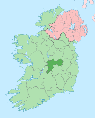
County Offaly is a county in Ireland. It is part of the Eastern and Midland Region and the province of Leinster. It is named after the ancient Kingdom of Uí Failghe. It was formerly known as King's County, in honour of Philip II of Spain. Offaly County Council is the local authority for the county. The county population was 82,668 at the 2022 census.

<span class="mw-page-title-main">Grand Canal (Ireland)</span> Canal in Ireland

The Grand Canal is the southernmost of a pair of canals that connect Dublin, in the east of Ireland, with the River Shannon in the west, via Tullamore and a number of other villages and towns, the two canals nearly encircling Dublin's inner city. Its sister canal on the Northside of Dublin is the Royal Canal. The last working cargo barge passed through the Grand Canal in 1960.

Bord na Móna, is a semi-state company in Ireland, created in 1946 by the Turf Development Act 1946. The company began developing the peatlands of Ireland with the aim to provide economic benefit for Irish Midland communities and achieve security of energy supply for the recently formed Irish Republic. The development of peatlands involved the mechanised harvesting of peat, which took place primarily in the Midlands of Ireland.

<span class="mw-page-title-main">Bog of Allen</span>

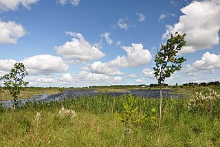
The Bog of Allen is a large raised bog in the centre of Ireland between the rivers Liffey and Shannon.

<span class="mw-page-title-main">Ferbane</span> Town in County Offaly, Ireland

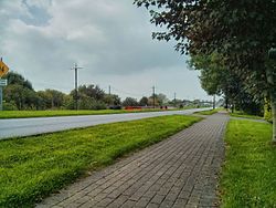
Ferbane is a town on the north bank of the River Brosna in County Offaly, Ireland, between Birr and Athlone at the junction of the N62 National secondary road and the R436 regional road. The name of the town is said to come from the white bog cotton which grows in the surrounding Bog of Allen.

<span class="mw-page-title-main">Shannonbridge</span> Village in County Offaly, Ireland

Shannonbridge is a village located on the River Shannon, at the junction of the R444 and R357 regional roads in County Offaly, Ireland. It lies within the townland of Raghra, at the borders of counties Offaly, Galway and Roscommon, with the majority of the population living east of the bridge in County Offaly. As of the 2016 census, the village had a population of 175. There are two housing estates within the village. Its location along Ireland's largest river and its proximity to Clonmacnoise have contributed to tourism being a key contributor to the local economy. The village is flanked by a Special Area of Conservation – the Shannon Callows. The physical environment consists of the River Shannon, callows, boglands and the Esker Riada. The village has one of the oldest bridges still in use over the River Shannon, completed in 1757.

<span class="mw-page-title-main">Daingean</span> Town in Leinster, Ireland

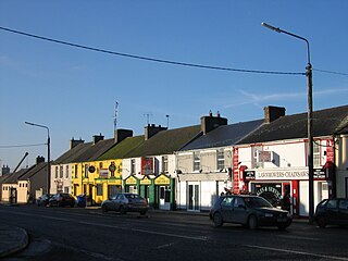
Daingean, formerly Philipstown, named after King Philip II of Spain, is a small town in east County Offaly, Ireland. It is situated midway between the towns of Tullamore and Edenderry on the R402 regional road. The town of Daingean had a population, as of the 2016 census, of 1,077. It is the principal town of the Daingean Catholic Parish. The other main poles of this parish are Ballycommon, Kilclonfert and Cappincur.

<span class="mw-page-title-main">Kilcormac</span> Small town in County Offaly, Ireland

Kilcormac is a small town in County Offaly, Ireland, located on the N52 at its junction with the R437 regional road, between the towns of Tullamore and Birr. It is a small town of 935 people, many of whom were previously employed by Bord na Móna to work the local peat bogs. The town is located near the Slieve Bloom Mountains. The Silver River flows through the town. The town was more commonly referred to as Frankford prior to Irish independence.

<span class="mw-page-title-main">Littleton, County Tipperary</span> Village in Munster, Ireland

Littleton is a village in County Tipperary, Ireland. It is within the townlands of Ballybeg and Ballydavid, about 18 km (11 mi) northeast of Cashel and to the southeast of Thurles. By-passed by the M8 in December 2008, Littleton lies at a crossroads on the R639 road. Its population was 394 at the 2016 census. It is in the barony of Eliogarty.

<span class="mw-page-title-main">Coole, County Westmeath</span> Village in Leinster, Ireland

Coole is a village in County Westmeath, Ireland, on the R395 regional road. It is situated on a plateau that overlooks the part of the Bog of Allen, cultivated for peat for fuel consumption purposes by Bórd na Móna, the government-owned peat production industry and for garden plant soil compost products by Harte Peat Ltd., a private enterprise, and Bórd na Móna.

<span class="mw-page-title-main">Rhode, County Offaly</span> Village in Leinster, Ireland

Rhode is a village in County Offaly, Ireland. It is situated on the R400 at its junction with the R441 which leads to Edenderry, 12 km to the east. Rhode village is on an "island" of high ground surrounded by an expanse of raised bog which forms part of the Bog of Allen.

<span class="mw-page-title-main">Clonmacnoise and West Offaly Railway</span> Railway in Ireland

The Clonmacnoise and West Offaly Railway was a former tourist attraction based on a narrow-gauge industrial railway in the Midlands of Ireland.

<span class="mw-page-title-main">John Griffith (engineer)</span> Welsh politician (1848-1938)

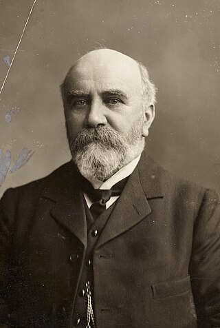
Sir John Purser Griffith was a Welsh-born Irish civil engineer and politician.

<span class="mw-page-title-main">Boora Bog</span>

Boora Bog is a cutaway peat bog situated in County Offaly, Ireland. Peat was harvested for fuel between the 1950s and 1970s, and the land is now being reclaimed for agricultural and eco-tourism use. There was a lake called Lough Boora, which was drained by Bord na Móna, but was not used for peat production: this area is now maintained as a nature reserve by the Irish Wildlife Trust. There are two angling lakes.

Kilnamadoo is a townland in County Fermanagh, Northern Ireland. It is situated within the civil parish of the area of Boho, as well as Fermanagh and Omagh district.

<span class="mw-page-title-main">Sculpture in the Parklands</span>

Raheenmore Bog is a raised bog north-west of Daingean, County Offaly, in Ireland. Since the 1980s the greater part of the bog has been maintained as a 162 hectare Nature Reserve, which is currently managed by the National Parks and Wildlife Service. A Special Area of Conservation covers 182 ha, including some land in private ownership.

<span class="mw-page-title-main">Offaly Way</span> Trail in County Offaly, Ireland

The Offaly Way is a long-distance trail in County Offaly, Ireland. It is 37 kilometres long and begins in Cadamstown and ends at Lemanaghan, on the R436 road between the towns of Clara and Ferbane. It is typically completed in two days. It is designated as a National Waymarked Trail by the National Trails Office of the Irish Sports Council and is managed by Offaly County Council, Bord na Mona and the Offaly Integrated Development Company. The trail provides a link between the Slieve Bloom Way and the Grand Canal Way.

The Derrinlough briquette factory is a production facility in County Offaly, Ireland, opened in 1957 and planned for closure in June 2023.

References

  1. "Census 2016 Sapmap Area: Settlements Pollagh". Central Statistics Office (Ireland) . Retrieved 19 May 2019.
  2. "Pollach/Pollagh". Placenames Database of Ireland. Government of Ireland - Department of Arts, Heritage and the Gaeltacht and Dublin City University . Retrieved 19 May 2019.
  3. "Virtual Tour of Parklands". 10 April 2007. Archived from the original on 27 September 2007.
  4. "Irish Peatland Conservation Council". 10 April 2007. Archived from the original on 19 May 2011. Retrieved 10 May 2007.
  5. "St. Mary's Church, Pollagh" (PDF). 10 April 2007. Archived from the original (PDF) on 24 July 2007. Retrieved 10 May 2007.
  6. "History of Grand Canal". 10 April 2007. Archived from the original on 6 October 2009. Retrieved 10 May 2007.
  7. "Plunkett Bridge, County Offaly". 10 April 2007.