This article needs additional citations for verification .(January 2017) |
Ferrard Fir Arda (Irish) | |
|---|---|
| Sovereign state | Ireland |
| County | Louth |
| Area | |
| • Total | 197.51 km2 (76.26 sq mi) |

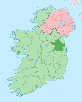
Ferrard (Irish : Fir Arda) is a barony in County Louth, Ireland.
This article needs additional citations for verification .(January 2017) |
Ferrard Fir Arda (Irish) | |
|---|---|
| Sovereign state | Ireland |
| County | Louth |
| Area | |
| • Total | 197.51 km2 (76.26 sq mi) |
Ferrard (Irish : Fir Arda) is a barony in County Louth, Ireland.
Ferrard derives its name from Fera Arda Ciannachta, "men of the high Ciannachta", referring to the uplands around Mount Oriel. [1]
Ferrard is found in south County Louth, between the White River, River Boyne and Mattock River.
Ferrard barony is bordered to the north by Ardee; to the west by Lower Slane, Upper Slane, County Meath and to the south by Drogheda and Lower Duleek, County Meath.
Ferrard derives its name from Fera Arda, or Fatharta, the ancient home of the Fir Arda Ciannachta. [2]
Below is a list of settlements in the historical Ferrard barony: [3]
Slane is a village in County Meath, in Ireland. The village stands on a steep hillside on the left bank of the River Boyne at the intersection of the N2 and the N51. As of the 2022 census, Slane's population was 1,445. The village and surrounding area contains many historic sites dating back over 5,000 years. The village centre, as it is laid-out today, dates mainly from the 18th century.

The River Boyne is a river in Leinster, Ireland, the course of which is about 112 kilometres (70 mi) long. It rises at Trinity Well, Newberry Hall, near Carbury, County Kildare, and flows towards the Northeast through County Meath to reach the Irish Sea between Mornington, County Meath, and Baltray, County Louth.
County Meath is a county in the Eastern and Midland Region of Ireland, within the province of Leinster. It is bordered by County Dublin to the southeast, Louth to the northeast, Kildare to the south, Offaly to the southwest, Westmeath to the west, Cavan to the northwest, and Monaghan to the north. To the east, Meath also borders the Irish Sea along a narrow strip between the rivers Boyne and Delvin, giving it the second shortest coastline of any county. Meath County Council is the local authority for the county.
Parsonstown is the former name of the town of Birr, County Offaly in Ireland.

Meath was a kingdom in Ireland from the 1st to the 12th century AD. Its name means "middle," denoting its location in the middle of the island.
Conaille Muirthemne was a Cruithin kingdom located in County Louth, Ireland, from before 688 to after 1107 approximately.
North Meath was a UK Parliament constituency in Ireland, returning one Member of Parliament (MP) from 1885 to 1922.
Brittas may refer to:

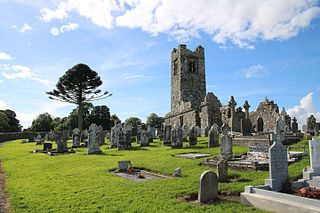
Tullyallen is a village, civil parish and townland 6 km north-west of the town of Drogheda in County Louth, Ireland. It is in the historic Barony of Ferrard. It is located in the historical Boyne Valley, in the Catholic parish of Mellifont ; it is also close to Newgrange, Knowth and Dowth burial mounds, Monasterboice monastery, and to the Battle of the Boyne site.
The Kings of Brega were rulers of Brega, a petty kingdom north of Dublin in medieval Ireland.

Airgíalla was a medieval Irish over-kingdom and the collective name for the confederation of tribes that formed it. The confederation consisted of nine minor kingdoms, all independent of each other but paying nominal suzerainty to an overking, usually from the most powerful dynasty. Airgíalla at its peak roughly matched the modern dioceses of Armagh and Clogher, spanning parts of counties Armagh, Monaghan, Louth, Fermanagh, Tyrone and Londonderry. Its main towns were Armagh and Clogher. The name's usage survives as a cultural area of folk tradition in South East Ulster and adjoining areas of County Louth.

Farney is a barony in County Monaghan, Ireland.
Donnchad Ua Cerbaill or Donnchadh Ó Cearbhaill, king of Airgíalla, fl. c. 1130–1168.
The Ciannachta were a population group of early historic Ireland. They claimed descent from the legendary figure Tadc mac Céin. Modern research indicates Saint Cianán and his followers may have been the origin behind the tribal name as it is a late construction similar in form to Eóganachta and Connachta. They first appear in historical sources in the 6th century, and were found in several parts of the island, including in Brega and Airgialla. The Ciannachta groups were absorbed over time. Modern descendants have formed a Clan Cian society.

Coleraine is a barony in County Londonderry, Northern Ireland. It connects to the north-Londonderry coastline, and is bordered by five other baronies: Keenaght to the west; Loughinsholin to the south; North East Liberties of Coleraine, Dunluce Upper, and the Kilconway to the east. Before its creation it was once a territory known as "Firnacreeve".

Farbill is a barony in east County Westmeath, in Ireland. It was formed by 1672. It is bordered by County Meath to the south and east and three other baronies: Fartullagh, Moyashel and Magheradernon and Delvin. The largest centre of population in the barony is the town of Kinnegad.

Ardee is a barony in County Louth, Ireland. Ity is named after the town of Ardee.
Drogheda is a barony in County Louth, Republic of Ireland.

Kells Lower is a barony in County Meath, Ireland.
Places in County Louth | ||
|---|---|---|
| Towns |  | |
| Villages and Townlands | ||