
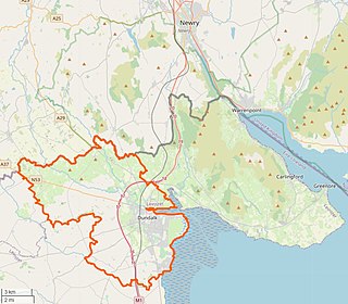
Dundalk is the county town of County Louth, Ireland. The town is on the Castletown River, which flows into Dundalk Bay on the east coast of Ireland. It is halfway between Dublin and Belfast, close to the border with Northern Ireland. It is surrounded by several townlands and villages that form the wider Dundalk Municipal District. It is the seventh largest urban area in Ireland, with a population of 43,112 as of the 2022 census.

Ardee is a town and townland in County Louth, Ireland. It is located at the intersection of the N2, N52, and N33 roads. The town shows evidence of development from the thirteenth century onward but as a result of the continued development of the town since then much of the fabric of the medieval town has been removed. The town is in a civil parish of the same name.

Dunleer is a town and townland in County Louth, Ireland. Dunleer is situated midway between Dundalk and Drogheda and is located on the junction of the R132, R169 and R170 regional roads that intersect the town. As of the 2022 census, the town had a population of 2,143.

Ballintra is a village in the parish of Drumholm in the south of County Donegal, Ireland, just off the N15 road between Donegal town and Ballyshannon. Ballintra lies on the northern bank of the Blackwater river. The river rises in the hills that lie inland from the town, and flows through a number of small lakes before spilling over a small waterfall in a gorge behind the village.

Stradone is a village located in County Cavan, Ireland. It is situated in the civil parish of Laragh six miles from Cavan, near the N3 road between Cavan and Virginia. Stradone is classified as a 'small village' in the Cavan County Council Development Plan 2014-2020.
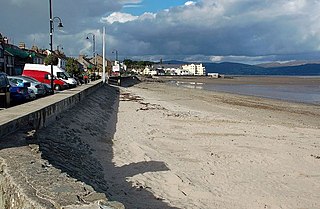
Blackrock is a seaside village just to the south of Dundalk, County Louth, Ireland. The village is in the townland of Haggardstown, in the Barony of Upper Dundalk, and part of the Dundalk metropolitan area. The population of the village is approximately 3,000.

Durrus is a village and civil parish in West Cork in Ireland. It is situated ten kilometres (6 mi) from Bantry in County Cork, at the head of the Sheep's Head and the Mizen Head peninsulas.

Hugginstown is a small village and townland in south County Kilkenny, Ireland. The local Gaelic Athletic Association club, Carrickshock GAA, play their home games in the village.

Knockbridge is a village in County Louth, Ireland. 7 km south-west of Dundalk, it is in the townland of Ballinlough in the historical barony of Dundalk Upper. As of the 2022 census, the village had a population of 759 people. Knockbridge won a "best kept village" award in the 2008 Tidy Towns competition.

Ravensdale is a village, townland and electoral division located at the foothills of the Cooley Mountains on the Cooley Peninsula in the north of County Louth in Ireland. Bordering with the townland of Doolargy, Ravensdale is approximately 8 km to the north of Dundalk. The dual carriageway between Dublin and Belfast runs nearby, and the R174 connects it with Jenkinstown.

Ballindrait is a townland, village and census town in County Donegal, Ireland. Located near Lifford, the village and townland of Ballindrait is in the civil parish of Clonleigh and the barony of Raphoe North. The Burn Dale flows through the centre of Ballindrait.

Farran is a village in County Cork, Ireland, in the parish of Ovens. It lies on the southside of the River Lee. Farran is 12 miles (19 km) west from Cork City on the N22 road.
Staplestown is a village and townland in north County Kildare, Ireland, located 40 kilometres west of Dublin. The village has a church, a school and is home to St Kevin's GAA. The local national (primary) school is Scoil Naomh Mhuire National School.

Stonetown is a small rural community spanning the townlands of Stonetown Upper and Stonetown Lower in County Louth. It lies in the parish of Louth, 14 west of Dundalk, and 7 km east of Carrickmacross. The community consists of a small chapel, a primary school, a football field and a community centre.
Geraldines are a GAA club from Haggardstown, County Louth, and Blackrock, County Louth, Ireland. The club fields Gaelic football teams in competitions organized by Louth GAA.
Dundalk Upper is a barony in County Louth, Ireland.
Aughnacliffe, officially Aghnacliff , is a village in County Longford, Ireland. It is located close to Lough Gowna and the border with County Cavan.

Rathtoe, also spelled Rathoe, is a village and townland in County Carlow, Ireland. The village is located in the civil parish of Gilbertstown, between Tullow and Ballon, County Carlow. The Burren River flows through the area. Rathtoe is a census town, and had a population of 304 as of the 2016 census.
Lordship is a rural area and census town in County Louth, Ireland. It is located in the civil parish of Ballymascanlan.

Ballysteen is a small village and townland in County Limerick, Ireland. It is located in the civil parish of Iveruss and the historical barony of Kenry.


