Dunleer

Last updated • 5 min readFrom Wikipedia, The Free Encyclopedia

Dunleer
Dún Léire
Lann Léire [1]
Town
Upper Main Street, Dunleer, Co. Louth - geograph.org.uk - 1310757.jpg
Upper Main Street, Dunleer
Ireland adm location map.svg
Red pog.svg
Dunleer
Location in Ireland
Coordinates: 53°49′48″N6°23′42″W / 53.830°N 6.395°W / 53.830; -6.395
Country Ireland
Province Leinster
County County Louth
Dáil Éireann Louth
EU Parliament Midlands–North-West
Elevation
39 m (128 ft)
Population
 (2022) [2]
2,143
Time zone UTC±0 (WET)
  Summer (DST) UTC+1 (IST)
Eircode routing key
A91
Telephone area code +353(0)41

Dunleer (Irish : Dún Léire) [3] is a town and townland in County Louth, Ireland. Dunleer is situated midway between Dundalk and Drogheda and is located on the junction of the R132, R169 and R170 regional roads that intersect the town. As of the 2022 census, the town had a population of 2,143. [2]

Contents

Dunleer used to be the principal town borough in the historical barony of Ferrard and has a charter dating back to 1252. The town is in a civil parish of the same name. [3]

History

Athclare Castle lies approximately 1.5km south of Dunleer Athclare, Co. Louth (Geograph-2494834-by-Mike-Searle).jpg
Athclare Castle lies approximately 1.5km south of Dunleer

The town has ties to the early sixth century Christian monastery of Lann Léire which was founded by brothers St. Furudran and St. Baothan. [4] [5] The monastery, which was located approximately where today Dunleer's Church of Ireland church is now located, [4] suffered numerous attacks over its history and was finally burned to the ground in 1148. [6] After a period of ruin, the Norman family of De Audley settled the area about thirty years later.[ citation needed ]

In 1513, John Barnewall was knighted and received large grants of land in the Dunleer area, including the manor of Dunleer. It is possible that it was at this time that the settlement became known as "Dún" Leire. While it is not determined when the name changed from "Lann Léire" to "Dún Léire", [1] [6] there is a reference to "the ville of Dún Leire" in records dating from 1227. The town was raised to the status of a "manor" at this time. Dunleer was subsequently granted a Market Town Charter in 1252, with the right to hold a Fair and Markets at various times. [7]

Dunleer is the principal town in the former Barony of Ferrard,[ citation needed ] and was granted an enhanced charter by King Charles II in 1671 to hold markets and fairs. [8] This was followed by a Royal Charter in 1678 establishing Dunleer as a municipal corporation (town borough council). [8] The corporation had 12 members (burgesses), [8] and annually elected a mayor, known as "sovereign" of the borough. It was the very last borough to be established in Ireland.[ citation needed ]

Dunleer, at one time, also elected two members of parliament to the old Irish House of Commons, which was abolished by the Act of Union in 1801. After the Act of Union between the English and Irish House of Commons, there was very little business for the corporation to do.[ citation needed ] It last convened in 1811. [8]

In 2023, Taoiseach Leo Varadkar visited the area. [9]

Demographics

Dunleer's population grew from 1,104 to 1,822 inhabitants between the 1991 and 2016 census. [10] [11] As of the 2022 census, it had grown further, to 2,143 inhabitants. [2]

Dunleer's proximity to Drogheda, Ardee, Dundalk, and its location as a crossroads on the main north–south economic corridor of Ireland, have contributed to its growth.[ citation needed ]

Industry

Dunleer has been a centre of industry from the 17th century, and previously had three water-powered mills.[ citation needed ] Rosevale; which was a flax mill (location of today's Glen Dimplex on the Barn Road), Skibbolmore; which was a steel pin manufacturing mill (later converted to flour milling and in 2021 restored as a house),[ citation needed ] and Glebe Mill (operating since 1698) which still produces stone ground flour in small amounts from time to time for the artisan trade.[ citation needed ]

Dunleer has also been a centre of domestic appliance manufacturing since the late 1930s. [12] [13] As of the 21st century, the area is home to several factories, including a GlenDimplex facility. [14]

Education

Dunleer is served by several schools, all of which are co-educational facilities.

The town has three mixed gender national (primary) schools, all of which are under the trusteeship of Dunleer Parish in the Roman Catholic Archdiocese of Armagh. These include: St. Kevins National School, St. Fintan's National School, and St. Brigids National School. [15]

Scoil Ui Mhuiri Post Primary, the only secondary school in the local area, is a mixed post-primary school which is located on Barn Road in Dunleer. [16] As of 2024, the school had over 630 pupils enrolled. [17] In November 2020, after a number of "major delays", [18] [19] a significant extension (incorporating 26 rooms, a new administration section, sensory room and outdoor area) was opened at the school. [18] This extension replaced a number of prefabs which had surrounded the school for several years. [18]

Amenities and community life

St. Brigid's Church, in Dunleer dates to the early 19th century St. Brigid's Church, Dunleer, Co. Louth - geograph.org.uk - 1311454.jpg
St. Brigid's Church, in Dunleer dates to the early 19th century

Dunleer has a Roman Catholic church (St. Brigid's) and a Church of Ireland church. There is also a community library which is located in a former bank. [20]

The Market House of Dunleer reopened in July 2014. [21] It is used as a civic centre in Dunleer, and is a civic body established by the Dunleer Community Development Board, acting as trustees of the building.[ citation needed ]

Dunleer has a number of community groups, including the Dunleer Tidy Towns committee. Represented by the Tidy Towns committee, Dunleer came second in the All-Ireland "small towns" category of the 2017 Pride of Place competition, and won both the Leinster and All-Ireland "small town" awards at the 2017 event. [22]

Sport

Colours of Lann Leire's GAA club Dunleer flag.png
Colours of Lann Léire's GAA club

Dunleer is home to Lann Léire GFC, the town's only Gaelic football club.

The local athletics club, Dunleer Athletic Club (Dunleer AC), has an outdoor athletics track on the Lann Léire sports campus. The athletics club also organise the annual Rás na hÉireann International Cross Country races. The 50th such event was hosted, by Dunleer AC, at Oldbridge in County Meath on 17 February 2019. [23]

The local Pavilion Centre has an indoor basketball arena and gym facilities.[ citation needed ]

Transport

Dunleer is located adjacent to the M1 motorway to its west, and there is access to and from the M1 via three motorway interchanges (M1 Junctions 12, 13 and 14). These linkages played a part in Dunleer becoming a commuter town for those working primarily in Dublin, Drogheda and Dundalk.[ citation needed ]

Dunleer station and platform on the Belfast-Dublin Line Dunleer Station - geograph.org.uk - 312354.jpg
Dunleer station and platform on the Belfast-Dublin Line

The town is served by a bus service, Bus Éireann routes 100 and 100X, which link the town to Drogheda, Dundalk and Dublin. [24] [25]

Dunleer railway station, a disused station on the Dublin-Belfast railway line, opened on 1 April 1851, closed for goods traffic on 2 December 1974 and closed altogether on 26 November 1984. [26] While the possibility of the station being rebuilt was referenced in local development plans published in 2009 by Louth County Council, [27] as of 2021 the National Transport Authority reportedly had "no plans" for a station at Dunleer. [28] The disused railway station building was refurbished in 2014.[ citation needed ]

Annalistic references

Related Research Articles

<span class="mw-page-title-main">Drogheda</span> Town in County Louth, Ireland, with suburbs in County Meath

Drogheda is an industrial and port town in County Louth on the east coast of Ireland, 43 km (27 mi) north of Dublin city centre. It is located on the Dublin–Belfast corridor on the east coast of Ireland, mostly in County Louth but with the south fringes of the town in County Meath, 40 km (25 mi) north of Dublin city centre. Drogheda had a population of 44,135 inhabitants in 2022, making it the eleventh largest settlement by population in all of Ireland, and the largest town in Ireland, by both population and area. It is the second largest in County Louth with 35,990 and sixth largest in County Meath with 8,145. It is the last bridging point on the River Boyne before it enters the Irish Sea. The UNESCO World Heritage Site of Newgrange is located 8 km (5.0 mi) west of the town.

<span class="mw-page-title-main">Dundalk</span> County town of County Louth, Ireland

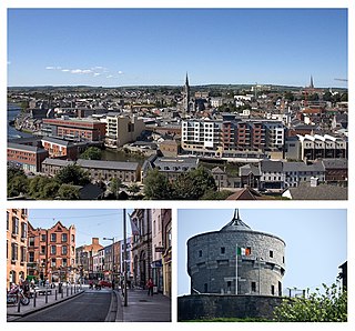
Dundalk is the county town of County Louth, Ireland. The town is situated on the Castletown River, which flows into Dundalk Bay on the north-east coast of Ireland, and is halfway between Dublin and Belfast, close to and south of the border with Northern Ireland. It is surrounded by several townlands and villages that form the wider Dundalk Municipal District. It is the seventh largest urban area in Ireland, with a population of 43,112 as of the 2022 census.

<span class="mw-page-title-main">County Louth</span> County in Ireland

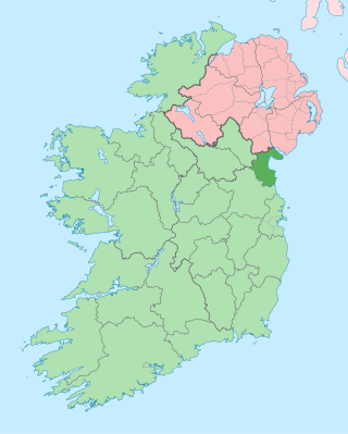
County Louth is a coastal county in the Eastern and Midland Region of Ireland, within the province of Leinster. Louth is bordered by the counties of Meath to the south, Monaghan to the west, Armagh to the north and Down to the north-east, across Carlingford Lough. It is the smallest county in Ireland by land area and the 17th most populous, with just over 139,100 residents as of 2022. The county is named after the village of Louth. Louth County Council is the local authority for the county.

<span class="mw-page-title-main">Pádraig Faulkner</span> Irish politician (1918–2012)

Pádraig Faulkner was an Irish Fianna Fáil politician who served as Ceann Comhairle of Dáil Éireann from 1980 to 1981, Minister for Defence 1979 to 1980, Minister for Posts and Telegraphs and Minister for Tourism and Transport from 1977 to 1979, Minister for Education from 1969 to 1973, Minister for the Gaeltacht and Minister for Lands from 1968 to 1969 and Parliamentary Secretary to the Minister for the Gaeltacht from 1965 to 1968. He served as a Teachta Dála (TD) for the Louth constituency from 1957 to 1987.

<span class="mw-page-title-main">Ardee</span> Town in County Louth, Ireland

Ardee is a town and townland in County Louth, Ireland. It is located at the intersection of the N2, N52, and N33 roads. The town shows evidence of development from the thirteenth century onward but as a result of the continued development of the town since then much of the fabric of the medieval town has been removed. The town is in a civil parish of the same name.

<span class="mw-page-title-main">Blackrock, County Louth</span> Seaside village in County Louth, Ireland

Blackrock is a seaside village just to the south of Dundalk, County Louth, Ireland. The village is in the townland of Haggardstown, in the Barony of Upper Dundalk, and part of the Dundalk metropolitan area. The population of the village is approximately 3,000.

<span class="mw-page-title-main">Laytown</span> Village in Leinster, Ireland

Laytown is a village in County Meath, Ireland, located on the R150 regional road and overlooking the Irish Sea. Historically it was called Ninch, after the townland it occupies. Together with the neighbouring villages of Mornington, Bettystown and Donacarney, it comprises the census town of Laytown–Bettystown–Mornington–Donacarney, which recorded a population of 15,642 in the 2022 census.

<span class="mw-page-title-main">Kingscourt</span> Town in County Cavan, Ireland

Kingscourt, historically known as Dunaree, is a town in County Cavan, Ireland. It is located near the Cavan–Meath border. The town was founded near the site of the old village of Cabra, by Mervyn Pratt, towards the end of the 18th century, and was completed by his brother, the Reverend Joseph Pratt. As of the 2022 census, the population was 2,955.

<span class="mw-page-title-main">Baltray</span> Village in County Louth, Ireland

Baltray is a village and townland in County Louth, Ireland. It sits on the northern shore of the River Boyne estuary.

<span class="mw-page-title-main">Bettystown</span> Village in County Meath, Ireland

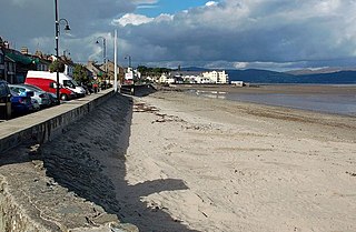
Bettystown, previously known as Betaghstown and transliterated to Beattystown/Bettystown, is a village in County Meath, Ireland. Together with the neighbouring villages of Laytown, Mornington and Donacarney, it comprises the urban area of Laytown–Bettystown–Mornington–Donacarney with a combined population of 15,642 at the 2022 census. During the Celtic Tiger, with increasing property prices in Dublin, Bettystown expanded to cater for large numbers of commuters to Dublin. The area was well known before that as a spot for Dublin summer holiday visitors, with a number of caravan parks and seaside amusements.

<span class="mw-page-title-main">Tinure</span> Village in County Louth, Ireland

Tinure, also Tenure, is a small village and townland in the parish of Monasterboice, County Louth, Ireland.

<span class="mw-page-title-main">Annagassan</span> Village in County Louth, Ireland

Annagassan is a village in the townland of Ballynagassan, County Louth, Ireland. It sits where the River Glyde enters the Irish Sea. It is approximately 16km south of Dundalk and 22km north of Drogheda. As of the 2022 census, Annagassan had a population of 189 people.

<span class="mw-page-title-main">Donore, County Meath</span> Village in Leinster, Ireland

Donore, historically Dunower, is a small village in County Meath, Ireland. It lies near Drogheda on the border between County Meath and County Louth, in the Boyne Valley on the road between Drogheda and the Brú na Bóinne heritage site. The village is in a civil parish of the same name.

<span class="mw-page-title-main">Dunleer railway station</span> Disused station in County Louth, Ireland

Dunleer railway station is a disused railway station on the Dublin-Belfast railway line in Dunleer, County Louth Ireland. Opened by the Dublin and Belfast Junction Railway in 1851, the station was the major stop between Dundalk and Drogheda. The station survived longer than most following the rationalisation of the railway network, until it was closed by Córas Iompair Éireann in 1984.

Hunterstown Rovers is a Gaelic football (GAA) club located in Ardee, County Louth, Ireland. The club's pitch is located about 3 kilometres south of Ardee on the main Dublin-Derry Road (N2). Hunterstown has teams at all age levels starting from U5's through to senior level.

Bus Éireann Route 101 is a bus route in Ireland, that runs from Talbot Street, in Dublin city centre, to the Bus Station in the town of Drogheda, via Swords, Balbriggan and Julianstown. It is operated by Bus Éireann and is the main bus route connecting Drogheda to Dublin. Routes 101X and 100X are peak time express services using the Dublin Port Tunnel and M1 motorway. In 2023 the 101 route was upgraded to a full 24-hour service from Sunday May 7th, with 293 departures targeted per week. The new timetable is operated by Bus Eireann and includes a fleet of new, fully accessible double and single deck coaches on the route.

The Louth Minor Football Championship is an annual competition organised by Louth GAA between the premier teams in minor (under-17) Gaelic football in County Louth.

Lann Léire CPG is a Gaelic Athletic Association (GAA) club that fields gaelic football teams in competitions organised by Louth GAA. It is based in the County Louth town of Dunleer. The club plays home matches at Páirc Uí Mhuirí, named after Larry Murray, the Louth priest who made a significant contribution to GAA affairs in the county and elsewhere.

St Kevin's GAA is a Gaelic Athletic Association (GAA) club that fields teams in competitions organised by Louth GAA. It is located in the townland of Philipstown, just over 2 miles from the town of Dunleer in mid-Louth.

The Louth Intermediate Football League is an annual Gaelic football competition organised by Louth GAA for Division 2 teams in County Louth.

References

  1. 1 2 Garstin, John Ribton (December 1921). "Some Inscriptions in Irish in the County of Louth". Journal of the County Louth Archaeological Society. 5 (1): 3–12. JSTOR   27728130. The origin of the name Dunleer has been a subject of controversy, but it seems to be tolerably settled according to Bishop Reeves, and Dr. Joyce following Dr. Todd that its original form was "Lann Léire" (Church of Austerity). How the "Lann" was exchanged into "Dun" is not clearly shown
  2. 1 2 3 "Census Mapping - Towns: Dunleer - Population Snapshot". Census 2022. Central Statistics Office. Retrieved 20 February 2024.
  3. 1 2 "Dún Léire/Dunleer". Placenames Database of Ireland (logainm.ie). Retrieved 8 October 2021.
  4. 1 2 "History of Dunleer Church". drogheda.armagh.anglican.org. Drogheda, Ardee and Collon Union, Kilsaran Union. Retrieved 20 February 2024.
  5. "De hellige Baithin og Furudran av Dunleer (500-t)". Den katolske kirke (in Norwegian). Retrieved 26 March 2024.
  6. 1 2 Ó Fachtna, Pádraig (1954). "Dunleer through the Ages". Seanchas Ardmhacha: Journal of the Armagh Diocesan Historical Society. 1 (1): 151–162. doi:10.2307/29740577. ISSN   0488-0196. JSTOR   29740577.
  7. O'Flanagan, James Roderick (1870). Lives of the Lord Chancellors and Keepers of the Great Seal of Ireland.
  8. 1 2 3 4 Lewis, Samuel, ed. (1837). "Dunleer". A Topographical Dictionary of Ireland . Dublin: Lewis.
  9. "Around the Districts: Dunleer and Slane". Independent.ie. 9 August 2023. Retrieved 20 February 2024.
  10. "Dunleer (Ireland) Census Town". City Population. Retrieved 8 February 2020.
  11. "Sapmap Area - Settlements - Dunleer". Census 2016. Central Statistics Office. April 2016. Retrieved 8 February 2020.
  12. "The story of GEC Dunleer in the words of the people who made it". Dundalk Democrat. 15 November 2014. Retrieved 20 February 2024.
  13. "Dunleer's factory days recalled". Drogheda Independent. 11 October 2014. Retrieved 20 February 2024.
  14. "Glen Dimplex to invest €15million in Louth but jobs cuts planned for later in 2024". The Argus. 8 February 2024. Retrieved 20 February 2024.
  15. "Schools". dunleerparish.ie. Dunleer Parish. Retrieved 20 February 2024.
  16. "Scoil Ui Mhuiri, SchoolDays". www.schooldays.ie. Retrieved 1 August 2018.
  17. "Directory Page - Scoil Ui Mhuiri". gov.ie. Department of Education. 22 January 2024. Retrieved 19 February 2024.
  18. 1 2 3 "Multi-million euro school extension delight for Dunleer". Drogheda Independent. 7 November 2020. Retrieved 20 February 2024.
  19. Murphy, Hubert (7 July 2018). "Anxious times for Dunleer extension". Drogheda Independent. independent.ie. Retrieved 1 August 2018.
  20. "Former County Louth bank building transformed into modern new Dunleer Library". Drogheda Independent. 12 September 2024. Retrieved 25 January 2025.
  21. "People of Dunleer can be proud of Market House restoration project". Dundalk Democrat. 31 July 2014. Retrieved 20 February 2024.
  22. "History of Dunleer Tidy Towns". dunleertidytowns.ie. Retrieved 20 February 2024. Dunleer came in second in our category of small towns in the whole of Ireland in the Pride of Place Competition in 2016 [..] The following year in 2017 [..] Dunleer was announced as winners of the Leinster Section of the Competition and [..] also as the winner in the All-Ireland small towns category
  23. "50th Rás na hÉireann - Larry Mc Guill Rás na hÉireann 2019 - Celebrating our 50th Rás event". dunleerac.net. Retrieved 20 February 2024.
  24. "Expressway Route 100 - Dublin to Dundalk" (PDF). Bus Éireann. Retrieved 20 February 2024.
  25. "Bus stop reinstated in Dunleer". Dundalk Democrat. 15 February 2024. Retrieved 20 February 2024.
  26. "Dunleer station" (PDF). Railscot - Irish Railways. Retrieved 12 October 2007.
  27. "Louth County Council Development Plan Review (pre-draft submissions) 2009-2015" (PDF). 2009.
  28. "Dunleer station hopes dashed as National Transport Authority says it has no plans for it". Drogheda Independent. Independent News & Media. 6 February 2021. Retrieved 23 October 2021.