Clogherhead

Last updated

Clogherhead
Ceann Chlochair
Village
Ceann Chlochair Tra - geograph.org.uk - 491566.jpg
Beach at Clogherhead
Ireland adm location map.svg
Red pog.svg
Clogherhead
Location in Ireland
Coordinates: 53°47′31″N6°14′17″W / 53.792°N 6.238°W / 53.792; -6.238
Country Ireland
Province Leinster
County County Louth
Dáil constituency Louth
EU Parliament Midlands–North-West
Population
 (2016) [1]
2,145
Irish Grid Reference O157840
Clogherhead Beach in autumn Clogherhead Beach.jpg
Clogherhead Beach in autumn

Clogherhead (Irish : Ceann Chlochair, meaning 'rocky headland ') [2] is a fishing village in County Louth, Ireland. Located in a natural bay on the east coast it is bordered by the villages of Annagassan to the north and Termonfeckin to the south. It has a population of 2,145 according to the 2016 census. It is located in the townlands of Clogher and Callystown, about 12 km (7 mi) northeast of Drogheda. As a seaside village, its main industries are fishing and farming, and there has been an RNLI lifeboat stationed in the village for over 100 years. [3]

Contents

Name

Historically, the village was known simply as Clogher (Clochair) or Killclogher (Cill Chlochair) [4] [5] while the headland was called Clogher Head. Today the headland remains Clogher Head, the village is called Clogherhead and the townland they are in is called Clogher.

The headland has a walking trail from the village along steep sea cliffs to the nearby harbour of Port Oriel (Port Oirialla). At low tide, it is also possible to walk the beach as far as the Boyne Estuary.[ citation needed ] From the headland and at the harbour there are views of Ireland's east coast from the Mourne and Cooley Mountains in the north as far south as Lambay Island and the Rockabill Lighthouse.[ citation needed ]

The headland is also the site of the Red Mans Cave, where Cromwellian soldiers are reputed to have put to death a number of Catholic Priests during the time of the Cromwellian Wars of 1649.[ citation needed ]

Public transport

Bus Éireann route 189 serves Clogherhead, linking it to Drogheda. Most buses operate via Termonfeckin and Baltray though a few go via Grangebellew and Ballymakenny. [6] Drogheda railway station is approximately 13 km distant.

Economy

Clogherhead is a tourist destination, and the village has a sandy Blue Flag beach [7] which extends from near the lifeboat station and on to the Boyne estuary.

Clogherhead hosts the Seafood Rocks festival, [8] a successor to the former Clogherhead Prawn Festival. [9]

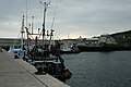
Port Oriel is a fishing port with a large fleet, and also the harbour provides a platform for onshore sea fishing for anglers.[ citation needed ]

Oriel Sea Salt and Oriel Sea Minerals are produced at Clogherhead and have protected designation of origin.

Amenities

The village has two main beaches. Port Beach in the centre of the village is a Blue Flag beach with the Neptune watersports centre which is run by the local council. The centre is the location for Celtic Adventures which provides schools and groups with a range of sports and training services including watersports, archery and climbing. In addition, it is the location for the local RNLI lifeboat station which houses a Mersey class lifeboat, the Doris Bleasdale. The other beach is on the north side of the village and is known as the 'Big Strand'. Both have bathing facilities with a lifeguard on duty at the village beach during summer months.

There are three public houses in the village, as well as a number of restaurants.[ citation needed ]

Education

Callystown National School (a Catholic school under the trusteeship of the Archbishop of Armagh) has been in "official" existence since 1832. [10] It is located on the north side of the village with access through the estate of John Kirk Park. [11] As of the 21st century, it has approximately 300 pupils and has been extended a number of times to cater for the population growth in the village and an influx of pupils from the surrounding areas.

Sport

As well as fishing and watersports, the local Gaelic Athletic Association club, Dreadnots Gaelic Football Club, have had three senior players in the Louth County team: Pádraig Rath, Anthony Williams, and James Califf. The club reached the Louth senior championship finals in 2012 and 2014 losing to St Patrick's on both occasions. [12] [13]

Links golf courses nearby include Seapoint Golf Club located at Termonfeckin, and County Louth Golf Club (which hosted the Irish Open in 2004 and again in May 2009) located at Baltray. There is also a pitch and putt course.[ citation needed ] Walshestown clay-pigeon shooting club is near Clogherhead at Murray's Cross. [14]

Clogherhead has been used as a filming location for a number of films, including: [15]

Songs featuring this town include "Is Clogherhead Like it Used to Be". [19]

Notable people

See also

Related Research Articles

<span class="mw-page-title-main">County Louth</span> County in Ireland

County Louth is a coastal county in the Eastern and Midland Region of Ireland, within the province of Leinster. Louth is bordered by the counties of Meath to the south, Monaghan to the west, Armagh to the north and Down to the north-east, across Carlingford Lough. It is the smallest county in Ireland by land area and the 17th most populous, with just over 139,100 residents as of 2022. The county is named after the village of Louth. Louth County Council is the local authority for the county.

<span class="mw-page-title-main">Ballycotton</span> Coastal village in County Cork, Ireland

Ballycotton is a coastal village in County Cork, Ireland, situated about 25 miles (40 km) east of Cork city. It is a fishing village that sits on a rocky ledge overlooking Ballycotton Bay and has a sandy beach that stretches for about 25 kilometres (16 mi) east to Knockadoon Head. The current village is actually a re-settlement of an older village which is now entirely underwater. Ballycotton experiences severe coastal erosion with metres of land crumbling into the sea every few years. It is a site of international research interest on coastal erosion.

<span class="mw-page-title-main">Rosslare Harbour</span> Village in County Wexford, Ireland

The village of Rosslare Harbour, also known as Ballygeary, grew up to serve the needs of the harbour of the same name, first developed in 1906 by the Great Western Railway and the Great Southern and Western Railway to accommodate steamferry traffic between Great Britain and Ireland. This port also serves France and Spain, traffic is mainly roll-on roll-off (RoRo). Rosslare Harbour railway station opened on 30 August 1906.

<span class="mw-page-title-main">Mellifont Abbey</span> First Cistercian abbey built in Ireland

Mellifont Abbey, was a Cistercian abbey located close to Drogheda in County Louth, Ireland. It was the first abbey of the order to be built in Ireland. In 1152, it hosted the Synod of Kells-Mellifont. After its dissolution in 1539, the abbey became a private manor house. This saw the signing of the Treaty of Mellifont in 1603 and served as William of Orange's headquarters in 1690 during the Battle of the Boyne.

<span class="mw-page-title-main">Moelfre, Anglesey</span> Village and community in Anglesey, Wales

Moelfre ( ) is a village, a community and, until 2012, an electoral ward on the north-east coast of the Isle of Anglesey in Wales. The community area covers the village and harbour, and several smaller, dispersed settlements. It includes six scheduled Iron Age hut groups and many other sites of archaeological interest. The harbour was formerly a local fishing port; a lifeboat station has been based here since 1854. Among many shipwrecks off the coast was that of the Royal Charter in 1859. Near the modernised lifeboat station is the RNLI Seawatch Centre. The coastline includes a rocky headland north of the village and a large sandy beach at Lligwy Bay, both traversed by the Anglesey Coastal Path. The 2011 census measured the village population as 710. It was estimated at 614 in 2019.

<span class="mw-page-title-main">Groomsport</span> Suburb of Bangor, County Down, Northern Ireland

Groomsport is a suburb of Bangor in County Down, Northern Ireland. It is on the south shore of Belfast Lough and on the north coast of the Ards Peninsula. Groomsport has a population of 3,005 people according to the 2011 Census. It is part of the Ards and North Down Borough.

<span class="mw-page-title-main">Cadgwith</span> Human settlement in England

Cadgwith is a village and fishing port in Cornwall, England, United Kingdom. It is on the Lizard Peninsula between The Lizard and Coverack. It is in the civil parish of Grade Ruan.

<span class="mw-page-title-main">Laytown</span> Village in Leinster, Ireland

Laytown is a village in County Meath, Ireland, located on the R150 regional road and overlooking the Irish Sea. Historically it was called Ninch, after the townland it occupies. Together with the neighbouring villages of Mornington, Bettystown and Donacarney, it comprises the census town of Laytown–Bettystown–Mornington–Donacarney, which recorded a population of 15,642 in the 2022 census.

<span class="mw-page-title-main">Termonfeckin</span> Village in County Louth, Ireland

Termonfeckin or Termonfechin is a small village and townland in County Louth, Ireland. It is within a civil parish of the same name, and is 8 km (5.0 mi) north-east of Drogheda. The population of the village almost quadrupled in the period between the 1996 and 2022 census, growing from 530 to 1,983 inhabitants.

<span class="mw-page-title-main">Courtown</span> Village in County Wexford, Ireland

Courtown is a village in County Wexford, Ireland. It was developed after Lord Courtown ordered the construction of a harbour during the Famine years, 1839–1846. The economic boost of the new harbour led to a small village developing with fishing being the primary economy of the village.

<span class="mw-page-title-main">Baltray</span> Village in County Louth, Ireland

Baltray is a village and townland in County Louth, Ireland. It sits on the northern shore of the River Boyne estuary.

<span class="mw-page-title-main">Togher, County Louth</span> Civil parish in County Louth, Ireland

Togher is a large parish in County Louth, Ireland. A rural parish in the Roman Catholic Archdiocese of Armagh, Togher is situated approximately halfway between Drogheda and Dundalk.

<span class="mw-page-title-main">Mornington, County Meath</span> Village in Leinster, Ireland

Mornington is a coastal village on the estuary of the River Boyne in County Meath, Ireland approximately 5 km downriver from the centre of Drogheda. Together with the neighbouring villages of Laytown, Bettystown and Donacarney, it comprises the urban area of Laytown–Bettystown–Mornington–Donacarney with a combined population of 15,642 at the 2022 census.

Clogher is a village in County Tyrone, Northern Ireland, seat of a cathedral, and former parliamentary borough

<span class="mw-page-title-main">Annagassan</span> Village in County Louth, Ireland

Annagassan is a village in the townland of Ballynagassan, County Louth, Ireland. It sits where the River Glyde enters the Irish Sea. As of the 2022 census, Annagassan had a population of 189 people.

<span class="mw-page-title-main">Sandpit, County Louth</span> Village in County Louth, Ireland

Sandpit is a small village in the rural hinterland of Drogheda in County Louth, Ireland. It lies in the townland of Milltown, which had a population of 213 as of the 2011 census.

<span class="mw-page-title-main">Ferrard</span> Barony in Louth, Ireland

Ferrard is a barony in County Louth, Ireland.

<span class="mw-page-title-main">Clogherhead Lifeboat Station</span> RNLI Lifeboat Station in Ireland, Ireland

Clogherhead Lifeboat Station is situated in Clogherhead, Co Louth, Ireland and has been in operation since 1899

Baltray Lifeboat Station is a former Royal National Lifeboat Institution (RNLI) station, located at The Haven, in the village of Baltray, on the north side of the River Boyne, near Drogheda in County Louth, Ireland.

<span class="mw-page-title-main">Blackrock Lifeboat Station</span> Former lifeboat station in County Louth, Ireland

Blackrock Lifeboat Station is a former Royal National Lifeboat Institution (RNLI) station, located in the village of Blackrock, on the south side of Dundalk Bay, in County Louth, Ireland.

References

  1. "Sapmap Area - Settlements - Clogherhead". Census 2016. CSO . Retrieved 25 December 2019.
  2. "Clogherhead". logainm.ie.
  3. "Clogherhead Lifeboat Station". The Royal National Lifeboat Institution. Retrieved 7 June 2024.
  4. CLOGHER, or KILCLOGHER in Lewis Topographical Dictionary of Ireland (1837)
  5. Placenames Database of Ireland (see archival records)
  6. "Planned Revision to Route 189/189A Ashbourne-Drogheda -Clogher Head-Grangebellow service". Bus Éireann . 13 November 2013.
  7. Clogherhead beach regains Blue Flag status (retrieved 5 June 2009)
  8. "Celebrate Irish Food and Culture at SeaFood Rocks Festival In Louth". TheTaste.ie. Retrieved 7 June 2024.
  9. "Clogherhead Prawn Festival - Home". Archived from the original on 16 October 2010. Retrieved 15 June 2010.
  10. "School history". Callystown N.S.
  11. Historyof Callystown National School Archived 15 January 2007 at the Wayback Machine
  12. "Louth SFC final: Keenan proves the difference for Pat's". Hogan Stand . 31 October 2011.
  13. Carroll, Joe (29 September 2014). "O'Connor helps St Pat's over the line". Irish Examiner .
  14. "Shooting club targets recruitment boost". Independent News & Media. Irish Independent. 21 February 2006. Retrieved 7 June 2024.
  15. "Movie Locations in Ireland". Archived from the original on 7 July 2011. Retrieved 24 October 2007.
  16. Locals get in character
  17. The Devil's Own at IMDb OOjs UI icon edit-ltr-progressive.svg
  18. Captain Lightfoot at the Internet Movie Database
  19. http://www.callystownnationalschool.ie Archived 23 December 2006 at the Wayback Machine and source podcast 9