Related Research Articles
Newtown may refer to:

County Tipperary is a county in Ireland. It is in the province of Munster and the Southern Region. The county is named after the town of Tipperary, and was established in the early 13th century, shortly after the Norman invasion of Ireland. It is Ireland's largest inland county and shares a border with eight counties, more than any other. The population of the county was 159,553 at the 2016 census. The largest towns are Clonmel, Nenagh and Thurles.

North Tipperary was a county in Ireland in the province of Munster. It was named after the town of Tipperary and consisted of 48% of the land area of the traditional county of Tipperary. North Tipperary County Council was the local authority for the county. In 2011, the population of the county was 70,322.

South Tipperary was a county in Ireland in the province of Munster. It was named after the town of Tipperary and consisted of 52% of the land area of the traditional county of Tipperary. South Tipperary County Council was the local authority for the county. The population of the county was 88,433 according to the 2011 census. It was abolished on 1 June 2014, and amalgamated with North Tipperary to form County Tipperary under a new Tipperary County Council.
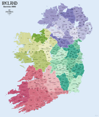
In Ireland, a barony is a historical subdivision of a county, analogous to the hundreds into which the counties of England were divided. Baronies were created during the Tudor reconquest of Ireland, replacing the earlier cantreds formed after the original Norman invasion. Some early baronies were later subdivided into half baronies with the same standing as full baronies.
Birdhill is a village in County Tipperary, Ireland. It is in the barony of Owney and Arra and is part of the parish of Newport, Birdhill and Toor in the Roman Catholic Archdiocese of Cashel and Emly. Its Irish name was historically anglicised as Knockan or Knockaneeneen.
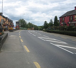
Newtown is a town in County Tipperary, Ireland. It is located on the R494 regional road 7 km (4.3 mi) west of Nenagh. As of the 2016 census, the population was 309. It is in the barony of Owney and Arra. It is also part of the parish of Youghalarra in the Roman Catholic Diocese of Killaloe.
Ormond Lower is a barony in County Tipperary, Ireland. This geographical unit of land is one of 12 baronies in County Tipperary. Its chief town is Nenagh. The barony lies between Ormond Upper to the south-east and Owney and Arra to the south-west. As a "peninsula", it is surrounded on three sides by counties Galway and Offaly.
Owney and Arra is a barony in County Tipperary, Ireland. This geographical unit of land is one of 12 baronies in County Tipperary. Its chief town is Newport. The barony lies between Ormond Lower to the north, Kilnamanagh Upper to the south and Ormond Upper to the east. To the west lies the River Shannon which separates it from County Clare. The territory is currently administered by Tipperary County Council.
Ikerrin is a barony in County Tipperary, Ireland. This geographical unit of land is one of 12 baronies in County Tipperary. Its chief town is Roscrea. The barony lies between Eliogarty to the south and Ormond Upper to the west. As a "peninsula", it is surrounded on three sides by counties Offaly and Laois. The territory is currently administered by Tipperary County Council.

Eliogarty is a barony in County Tipperary, Ireland. This geographical unit of land is one of 12 baronies in County Tipperary. Its chief town is Thurles. The barony lies between Ikerrin to the north, Kilnamanagh Upper to the west, Middle Third to the south and County Kilkenny to the east. It is currently administered by Tipperary County Council.
Kilnamanagh Upper is a barony in County Tipperary, Ireland. This geographical unit of land is one of 12 baronies in County Tipperary. Its chief town is Borrisoleigh. The barony lies between Ormond Upper to the north, Kilnamanagh Lower to the south and Eliogarty to the east. It is currently administered by Tipperary County Council.
Clanwilliam is a barony in County Tipperary, Ireland. This geographical unit of land is one of 12 baronies in County Tipperary. Its chief town is Tipperary. The barony lies between Kilnamanagh Lower to the north, Iffa and Offa West to the south and Middle Third to the east. It is currently administered by Tipperary County Council.
Kilnamanagh Lower is a barony in County Tipperary, Ireland. This geographical unit of land is one of 12 baronies in County Tipperary. Its chief town is Dundrum. The barony lies between Kilnamanagh Upper to the north, Clanwilliam to the south and Eliogarty to the east. It is currently administered by Tipperary County Council.
Iffa and Offa West is a barony in County Tipperary, Ireland. This geographical unit of land is one of 12 baronies in County Tipperary. Its chief town is Cahir. The barony lies between Clanwilliam to the north-west, Middle Third to the north-east and Iffa and Offa East to the east. The area is currently administered by Tipperary County Council. The barony is within the geographic remit of the Roman Catholic Diocese of Waterford and Lismore.
Iffa and Offa East is a barony in County Tipperary, Ireland. This geographical unit of land is one of 12 baronies in County Tipperary. Its chief town is Clonmel. The barony lies between Iffa and Offa West to the west, Middle Third to the north-west and Slievardagh to the north-east. It is currently administered by Tipperary County Council. The entire barony lies within the geographic remit of the Roman Catholic Diocese of Waterford and Lismore with the exception of the parish of Clerihan which is in the Roman Catholic Archdiocese of Cashel and Emly.
Middle Third is a barony in County Tipperary, Ireland. This geographical unit of land is one of 12 baronies in County Tipperary. Its chief town is Cashel. The barony lies between Eliogarty to the north, Iffa and Offa East to the south, Clanwilliam to the west and Slievardagh to the east. It is currently administered by Tipperary County Council.
Slievardagh is a barony in County Tipperary, Ireland. This geographical unit of land is one of 12 baronies in County Tipperary. Its chief town is Mullinahone. The barony lies between Eliogarty to the north, Iffa and Offa East to the south and Middle Third to the west. It is currently administered by Tipperary County Council.
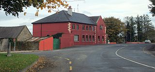
Donohill or Dunohil is a village and civil parish in County Tipperary, Ireland. It is one of nine civil parishes in the barony of Kilnamanagh Lower. The village is located on the R497 regional road from Nenagh to Tipperary town, 8 kilometres north of Tipperary.

Tulla Lower is a barony in County Clare, Ireland. This ancient geographical division of land is in turn divided into eight civil parishes.
References
- ↑ Murphy, Donal A. (1994). The two Tipperarys: the national and local politics —devolution and self-determination— of the unique 1838 division into two ridings, and the aftermath. Regional studies in political and administrative history. Vol. 1. Relay. p. 71. ISBN 0-946327-14-9.
- ↑ Database of Ireland - civil parishes.
