
Glenties is a town in County Donegal, Ireland. It is situated where two glens meet, north-west of the Bluestack Mountains, near the confluence of two rivers. Glenties is the largest centre of population in the parish of Iniskeel. Glenties has won the Irish Tidy Towns Competition five times in 1958, 1959, 1960, 1962 and 1995. As of the 2022 census, the population was 927.

The Rosses is a traditional 'district' in the west of County Donegal in Ulster, the northern province in Ireland. The Rosses has a population of over 7,000 centred on the town of Dungloe, which acts as the educational, shopping and civic centre for the area. Defined by physical boundaries in the form of rivers, as well as history and language use, the area has a distinctive identity, separate from the rest of County Donegal. The extensive district lies between the parish and district of Gweedore to the north and the town of Glenties to the south. A large part of the Rosses is in the Gaeltacht, which means that Irish is the spoken language. The Rosses, Cloughaneely and Gweedore, known locally as "the three parishes", with 16,000 Irish speakers, together form a social and cultural region different from the rest of the county, with Gweedore serving as the main centre for socialising and industry. Gaeltacht an Láir is another Irish-speaking area.
West Donegal was a UK Parliament constituency in Ireland, returning one Member of Parliament from 1885 to 1922.

Loch an Iúir, anglicised as Loughanure, is a village and townland in The Rosses, a district in the west of County Donegal in Ulster, the northern province in Ireland. The village is in the Gaeltacht, being halfway between Gweedore and Dungloe, with the N56 road passing through the village. According to the 2016 census, 37% of the population spoke Irish on a daily basis outside the education system. The village of Loughanure lies within the Barony of Boylagh.

The N56 road is a national secondary road in the Republic of Ireland that runs from Donegal Town clockwise to Letterkenny. As originally designated, it included the section of the N13 between Stranorlar and Letterkenny, forming a circular route including parts of the N15.

Leitir Mhic an Bhaird or Leitir Mhic a' Bhaird is a Gaeltacht village in the Rosses region of County Donegal, Ireland. The village, known colloquially as Leitir, is between the larger towns of Glenties and Dungloe. It is also a civil parish in the historic barony of Boylagh.
Bantry is a barony in the west of County Cork in Ireland. Patrick Weston Joyce said the name Beanntraí means "descendants of Beann [Ban]", a son of Conchobar mac Nessa; similarly for the Wexford barony of Bantry. The barony borders the top end the southern shore of Bantry Bay. On the opposite shore is the barony of Bear. It is also bordered by Carbery West and Muskerry West to the northeast. To the north is County Kerry.
Barretts is a barony in northwest County Cork in Ireland. The name is derived from the Old English Barrett family.
Barrymore is a barony in County Cork in Ireland. It is the namesake of the Norman de Barry family, latterly created Earls of Barrymore. Barrymore is bordered by eight baronies:
Carbery East is a barony in County Cork in Ireland. It has been split since the nineteenth century into East and West Divisions.
Carbery West is a barony in County Cork in Ireland. It has been split since the nineteenth century into East and West Divisions.

Banagh is a historic barony in County Donegal in Ireland. Patrick Weston Joyce said the name Banagh came from Enna Bogaine, son of Conall Gulban, son of Niall of the Nine Hostages. It was created along with Boylagh when the former barony of Boylagh and Banagh was split in 1791 by an Act of the Parliament of Ireland.
Balrothery East is one of the baronies of Ireland. Originally part of the Lordship of Meath, it was then constituted as part of County Dublin. Today, it is in the modern county of Fingal.
Fermoy is a historical barony in County Cork in Ireland. It is bordered by the baronies of Orrery and Kilmore to the north-west; Duhallow to the west; Barretts to the south-west; Barrymore to the south; Condons and Clangibbon to the east; and Coshlea, County Limerick to the north. It is bounded to the south by the Nagle Mountains and the valley of the Munster Blackwater. The Ballyhoura Mountains mark the northern boundary. A tributary of the Blackwater, the Awbeg has two branches in its upper stretches; one branch forms the northern boundary while the other near Buttevant, forms the western limit. To the east, lies another Blackwater tributary, the Funcheon. Anomalously, the namesake town of Fermoy is actually in the barony of Condons and Clangibbon. The town with the greatest population in the barony is Mallow.
Smallcounty or Small County is a historical barony in County Limerick, Ireland. Settlements in the barony include Hospital, Herbertstown, Fedamore and Knockainy.
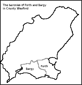
Forth is a barony in County Wexford in Ireland.
Leitrim is a barony in Ireland that lies partly in County Galway and partly in County Clare. It is located in the south-eastern corner of County Galway and the north-eastern corner of County Clare. Prior to 1898, the entire barony was contained in County Galway. The Local Government (Ireland) Act 1898 split the barony: part of the barony was transferred to County Clare. Leitrim is bounded, clockwise from the southwest, by the Clare baronies of Tulla Upper and Tulla Lower; the Galway baronies of Loughrea to the west, Kilconnell to the north, and Longford to the east; and by Lough Derg to the south and southeast. It measures 20 miles (32 km) from north to south and 9.5 miles (15.3 km) from east to west.
Killymard is a civil parish, in the barony of Banagh in the county of Donegal, and province of Ulster.
John Cunningham is an Irish former Gaelic footballer who played for Na Cealla Beaga and the Donegal county team.


