
Seamus Justin Heaney was an Irish poet, playwright and translator. He received the 1995 Nobel Prize in Literature. Among his best-known works is Death of a Naturalist (1966), his first major published volume. American poet Robert Lowell described him as "the most important Irish poet since Yeats", and many others, including the academic John Sutherland, have said that he was "the greatest poet of our age". Robert Pinsky has stated that "with his wonderful gift of eye and ear Heaney has the gift of the story-teller." Upon his death in 2013, The Independent described him as "probably the best-known poet in the world".

The Rosses is a traditional 'district' in the west of County Donegal in Ulster, the northern province in Ireland. The Rosses has a population of over 7,000 centred on the town of Dungloe, which acts as the educational, shopping and civic centre for the area. Defined by physical boundaries in the form of rivers, as well as history and language use, the area has a distinctive identity, separate from the rest of County Donegal. The extensive district lies between the parish and district of Gweedore to the north and the town of Glenties to the south. A large part of the Rosses is in the Gaeltacht, which means that Irish is the spoken language. The Rosses, Cloughaneely and Gweedore, known locally as "the three parishes", with 16,000 Irish speakers, together form a social and cultural region different from the rest of the county, with Gweedore serving as the main centre for socialising and industry. Gaeltacht an Láir is another Irish-speaking area.

Gweedore is a Gaeltacht (Irish-speaking) district and parish located on the Atlantic coast of County Donegal in the north-west of Ireland. Gweedore stretches some 26 kilometres (16 mi) from Glasserchoo and Bloody Foreland in the north to Crolly in the south and around 14 kilometres (9 mi) from Dunlewey in the east to Magheraclogher and Magheralosk in the west, and is sometimes described as one of Europe's most densely populated rural areas. It is the largest Irish-speaking parish in Ireland with a population of around 4,065, and is also the home of the northwest regional studios of the Irish-language radio service RTÉ Raidió na Gaeltachta, as well as an external campus of the University of Galway. Gweedore includes the settlements of Brinlack, Bunbeg, Derrybeg, Crolly and Dunlewey, and sits in the shade of County Donegal's highest peak, Errigal.
The Donegal Senior Football Championship is an annual football competition organised by Donegal GAA and contested by the highest-level clubs, to determine the best team in County Donegal. Since 2016, it has been known as Michael Murphy Sports and Leisure Donegal SFC after its headline sponsor.
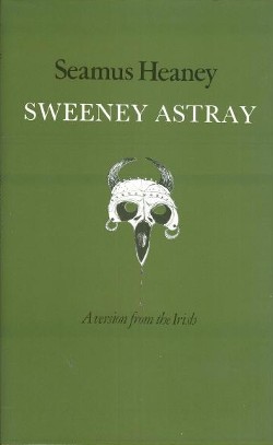
Sweeney Astray: A Version from the Irish is a version of the Irish poem Buile Shuibhne written by Seamus Heaney, based on an earlier edition and translation by J. G. O'Keeffe. The work was first published in 1983 and won the 1985 PEN Translation Prize for poetry.

An Bun Beag, meaning "the small river mouth", is a small Gaeltacht village and townland in County Donegal, Ireland. It is officially the smallest townland in Gaoth Dobhair (Gweedore), but today the name Bunbeg is used to describe a large region of the parish. It is situated between Derrybeg and the townland of Dore and is home to many of Gweedore's amenities and businesses. The Clady River flows into the Crolly River beside Bunbeg Quay, on the south-western outskirts of Bunbeg.
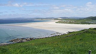
Narin, also Naran, is a small seaside village and townland in the parish of Ardara on the southwest coast of County Donegal, Ireland. The topography is rough rolling bogland and craggy low hills. Narin Strand is a sand beach approximately two kilometres long. Inishkeel island is located approximately 250 metres from the mainland in Gweebarra Bay and can be reached on foot at low tide by crossing a tidal sand bank. The population of Narin is spread sparsely around the countryside in mostly modern housing. There is a large tourist trade served by several bed and breakfasts and caravan parks. Local amenities consist of a pub, coffee shop and public toilets. There is also an 18-hole golf links with club house. Narin lies at an altitude of 12 metres and lies 8 km north of Ardara, 11 km northwest of Glenties and 13 km south of Dungloe. Brendan Behan stayed with his wife in Narin in 1961, where they spent much time swimming.

CLG Ghaoth Dobhair is a GAA club based in the parish of Gaoth Dobhair in northwest County Donegal, Republic of Ireland. They are one of the strongholds of Gaelic football in County Donegal.

CLG An Clochán Liath is a GAA club based in An Clochán Liath, a Gaeltacht town along the Wild Atlantic Way in west County Donegal, Ireland. The club fields both men's and ladies' teams at all age grades in Gaelic Football, Hurling, and Camogie.

Human Chain is the twelfth and final poetry collection by Seamus Heaney. It was first published in 2010 by the Faber and Faber.
Neil McGee is an Irish Gaelic footballer who plays for Gaoth Dobhair and, formerly, both the Donegal county team and the Ireland international rules football team.
Marty Boyle is an Irish Gaelic footballer who plays for Naomh Conaill and also, formerly, for the Donegal county team. He played for his county during Jim McGuinness's first spell as manager.
Odhrán Mac Niallais is an Irish Gaelic footballer who plays for Gaoth Dobhair and, formerly, for the Donegal county team.

Andrew John Hozier-Byrne, known professionally as Hozier, is an Irish musician, singer and songwriter. His music primarily draws from folk, soul and blues, often using religious and literary themes and taking political or social justice stances.

Hozier is the debut studio album by Irish musician Hozier. It was released on 19 September 2014 by Island Records and Rubyworks Records. Before the album's release, he attracted attention from his 2013 and 2014 EPs Take Me to Church (2013) and From Eden (2014), which contained songs that were later included on the album. Hozier collaborated with producer Rob Kirwan during its recording. Hozier has been described as a blues, soul and indie rock album with elements of gospel, R&B and folk music.
St Joseph's Gaelic Football Club was a Gaelic football club in County Donegal, Ireland.

"Someone New" is a song recorded by Irish singer-songwriter Hozier for his 2014 eponymous debut studio album. It was released on 2 March 2015 as the fifth single from the record and peaked at number 13 on the Irish Singles Chart. An accompanying music video was released featuring actress Natalie Dormer.
"Nina Cried Power" is a song recorded by Irish singer-songwriter Hozier, featuring vocals from American rhythm and blues and gospel singer Mavis Staples. It was released on 6 September 2018 as the lead single from Hozier's second studio album Wasteland, Baby!.
CLG Naomh Columba is a Gaelic football-only GAA club based in Gleann Cholm Cille in the south-west of County Donegal in the west of Ulster, the northern province in Ireland. The club fields both men's and ladies' teams from underage as far as senior level. They enjoy an intense rivalry with their neighbours, Cill Chartha (Kilcar), although the rivalry has subdued somewhat in the last number of years as the clubs have played in different divisions.

Wasteland, Baby! is the second studio album by Irish musician Hozier, released on 1 March 2019 by Rubyworks Records. It is Hozier's first album since 2014. The album includes the songs "Nina Cried Power" and "Shrike" from the 2018 EP Nina Cried Power, as well as the single "Movement". It was promoted by a North American tour beginning in March 2019, and a European tour in late summer to fall 2019. Wasteland, Baby! debuted atop the Irish Albums Chart and the Billboard 200, and has since been certified gold in the US.

