County Fermanagh is one of the thirty-two counties of Ireland, one of the nine counties of Ulster and one of six counties of Northern Ireland.

Kinawley or Kinawly is a small village, townland and civil parish straddling County Fermanagh, Northern Ireland and County Cavan, Republic of Ireland. The village and townland are both in the civil parish of Kinawley in the historic barony of Clanawley, while other areas of the parish are in the baronies of Knockninny in County Fermanagh and Tullyhaw in County Cavan. In the 2011 Census it had a population of 141 people.
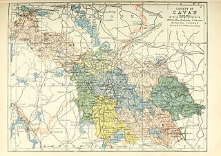
Tullyhaw is a Barony in County Cavan in Ireland. The area has been in constant occupation since pre-4000 BC. Located in the northwest of the county, it has been referred to as Cavan's panhandle. Tullyhaw was originally a túath within West Bréifne. It was later absorbed into East Bréifne in the sixteenth century.
The Bhotha Mhuintir Uí Fhialáin were an Irish tribe that lived in the area now known as Boho in County Fermanagh, Northern Ireland.

Mac Amhlaoibh and Mac Amhalghaidh are two different Gaelic patronymic names with different origins and meanings, but which share the same or similar Anglicisations. These Gaelic names are borne by at least three unrelated native Irish clans or septs.

Historically, Fermanagh, as opposed to the modern County Fermanagh, was a kingdom of Gaelic Ireland, associated geographically with present-day County Fermanagh. Fir Manach originally referred to a distinct kin group of alleged Laigin origins. The kingdom of Fermanagh was formed in the 10th century, out of the larger kingdom of Uí Chremthainn, which was part of the overkingdom of Airgíalla. By the late 11th century it had grown to cover all of what is now County Fermanagh. The kingdom came to be ruled by the Mag Uidhir (Maguire) clan from the late 13th century onward. They were based at Lisnaskea, and their royal inauguration site was nearby Sgiath Gabhra (Skeagoura), now called Cornashee. Under Hugh Maguire, Fermanagh was involved in the Nine Years' War against English rule. His successor, Cú Chonnacht Óg Mag Uidhir, was one of the Gaelic Irish leaders who fled Ireland during the Flight of the Earls. Fermanagh was subsequently merged into the Kingdom of Ireland as County Fermanagh.

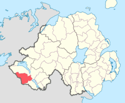
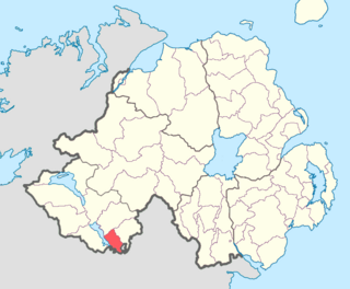
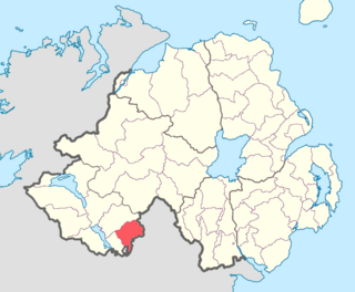
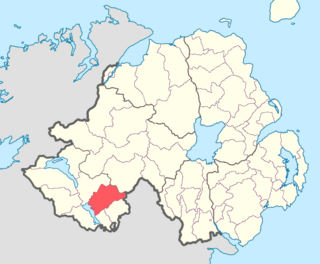
Knockninny is a barony in County Fermanagh, Northern Ireland. To its east lies Upper Lough Erne, and it is bordered by four other baronies in Northern Ireland: Clanawley to the north-west; Tirkennedy to the north; Magherastephana to the north-east; and Coole to the east. It also borders two baronies in the Republic of Ireland: Loughtee Lower to the south; and Tullyhaw to the south-west.
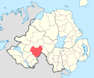
Coole is a barony in County Fermanagh, Northern Ireland. To its west lies Upper Lough Erne, and it is bordered by three other baronies in Northern Ireland: Knockninny to the west; Magherastephana to the north; and Clankelly. It also borders three baronies in the Republic of Ireland: Dartry to the east; Tullygarvey and Loughtee Lower to the south.
Clankelly is a barony in County Fermanagh, Northern Ireland. It is the only barony in County Fermanagh not connected to Lough Erne. It is bordered by two other baronies in Northern Ireland: Coole to the south-west; and Magherastephana to the north-west. It also borders two baronies in the Republic of Ireland: Monaghan to the north-east; and Dartree to the south-east.
Magherastephana is a barony in County Fermanagh, Northern Ireland. To its south-west lies Upper Lough Erne, and it is bordered by five other baronies: Tirkennedy to the west; Knockninny to the south-west; and Coole to the south; Clankelly to the south-east; and Clogher to the north-west.

Tirkennedy is a barony in County Fermanagh, Northern Ireland. To its west lies Lower Lough Erne and south Upper Lough Erne, and it is bordered by seven other baronies: Clanawley and Magheraboy to the west; Lurg and Omagh East to the north; Clogher to the east; Magherastephana and Knockninny to the south.

Magheraboy is a barony in County Fermanagh, Northern Ireland. To its east lies Lower Lough Erne, and it is bordered by three other baronies in Northern Ireland: Lurg to the north; Tirkennedy to the east; and Clanawley to the south It also borders two baronies in the Republic of Ireland: Tirhugh to the north; and Rosclogher to the south. The westernmost point of Magheraboy is also the westernmost point of Northern Ireland..

Lurg is a barony situated in the north of County Fermanagh, Northern Ireland. To its south lies Lower Lough Erne, and it is bordered by four other baronies in Northern Ireland: Magheraboy to the south; Tirkennedy to the south-east; Omagh West to the north; and Omagh East to the east. It also borders to the west the barony of Tirhugh in the Republic of Ireland.
Clogher is a barony in County Tyrone, Northern Ireland. It is bordered by four other baronies in Northern Ireland: Omagh East to the north; Dungannon Lower to the east; Magherastephana to the south; and Tirkennedy to the south-west. It also borders two baronies in the Republic of Ireland: Trough and Monaghan both to the south-east.
Cloncoohy is a townland in the Civil Parish of Tomregan, Barony of Knockninny, County Fermanagh, Northern Ireland.
Gortahurk, is a townland in the civil parish of Tomregan, County Fermanagh, Northern Ireland. It was also part of the barony of Knockninny.

Gortineddan is a townland in the Civil Parish of Tomregan, Barony of Knockninny, County Fermanagh, Northern Ireland.
Knockateggal is a townland in the Civil Parish of Tomregan, Barony of Knockninny, County Fermanagh, Northern Ireland.
Tonymore is a townland in the Civil Parish of Tomregan, Barony of Knockninny, County Fermanagh, Northern Ireland.

Ummera is a townland in the Civil Parish of Tomregan, Barony of Knockninny, County Fermanagh, Northern Ireland.